
Weird Law


Enclosed Cremation Cemetery (Bronze Age)
Site Name Weird Law
Classification Enclosed Cremation Cemetery (Bronze Age)
Alternative Name(s) Menzion Farm
Canmore ID 48576
Site Number NT02SE 8
NGR NT 0851 2346
Datum OSGB36 - NGR
Permalink http://canmore.org.uk/site/48576


- Council Scottish Borders, The
- Parish Tweedsmuir
- Former Region Borders
- Former District Tweeddale
- Former County Peebles-shire
NT02SE 8 0851 2346.
(NT 0851 2346) Homestead (NR)
OS 6" map (1962)
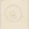
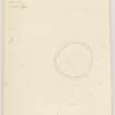
Enclosed Cremation Cemetery: This cremation cemetery stands at a height of 900' OD on a low ridge which rises a few feet above the broken marshy ground at the foot of the SE slopes of Weird Law. It was excavated in 1961. Before excavation, the monument appeared as a turf-covered stony bank, 8' in thickness and 1' in height, which enclosed a circular area measuring 32' in diameter. A low stony mound, roughly circular on plan and 14' in diameter, occupied the centre of the enclosure.
Excavation showed that the bank was formed by a band of stones: it was 6' to 8' in width and up to 1'8" in height, and there was no formal kerb. No entrance was discovered in the stretches of the bank that were examined and surface indications gave no hint of a gap of any kind in the unexcavated portions. Within the interior the stony mound proved to be pear-shaped, measuring 25' by 19' and 1'6" in average height. It was not centrally placed; whereas its SW end almost merged with the inner edge of the enclosing ring, there was a clear intervening space of up to 10' on the NW, NE, and SE. The space was featureless. When the stones forming the mound were removed, they were found to be covering a layer of burnt material about 2" in depth. Dug through this burnt layer, and into the underlying natural sand and gravel, there were five pits, oval or circular on plan and all about 1' in depth, some containing burnt material, including considerable quantities of cremated human bone and charcoal. Analysis of bone fragments revealed identifiable remains of two persons, one a young adult, possibly female, the other a child, sex unknown.
In addition to these five pits, there was a shallow oblong pit measuring 5'3" by 2'8" and just over 1' in depth, occupying an almost central position in relation to the enclosed stone ring. It was tightly packed with stones, the upper layer of which was blackened and scorched, indicating that the pit and its filling existed before the accumulation of the burnt layer.
Apart from two small unworked chert flakes, no relics were recovered, but a radiocarbon measurement made at the National Physical Laboratory on a sample of coal gave the age before the present (1950) as 3440 +- 90, equivalent to a date about 1490 BC.
The sequence of events as revealed by the excavations may be summarised as follows. A circular ritual enclosure, measuring 32' in diameter, was formed by a low band of stones. The oblong pit was dug in the centre of the enclosure, probably as part of the ceremonies that took place before the actual cremation. The pit was then packed with stones. The two bodies, possibly those of a mother and child, were then cremated inside the enclosure, and afterwards the remains were buried in pits and the whole area sealed beneath a protective mound of stones.
RCAHMS 1967, visited 1961
Generally as described.
Surveyed at 1:2500.
Visited by OS (RD) 3 August 1972
Sbc Note
Visibility: This site has been excavated.
Information from Scottish Borders Council

