
Ericstane


Scooped Settlement (Middle Iron Age)
Site Name Ericstane
Classification Scooped Settlement (Middle Iron Age)
Alternative Name(s) Braehead; Braefoot Linn
Canmore ID 48495
Site Number NT01SE 3
NGR NT 0690 1105
Datum OSGB36 - NGR
Permalink http://canmore.org.uk/site/48495


- Council Dumfries And Galloway
- Parish Moffat
- Former Region Dumfries And Galloway
- Former District Annandale And Eskdale
- Former County Dumfries-shire
NT01SE 3 0690 1105.
(NT 0690 1105) Fort (NR)
OS 6" map, (1962)
Fort, Ericstance: This fort, semi-oval in shape, with a ravine to the S, has been constructed from unusually adapted natural features. It measures 240' x 129' within a massive rampart of small stones, 5'-6' high; it has an external ditch 36' wide, 8' below the crest of the scarp and 5-6' below the couterscarp. These defences are artificial, but beyond this, a remarkable conformation of the ground has been utilised to provide on the upper half of the fort two outer ramparts and ditches, changing to a single rampart and ditch on the lower half. These outer mounds and hollows are clearly descernible as natural features on the higher ground above the fort, and, as they come into its immediate vicinity, they have been dug out and shaped to simulate artificial lines. The 8' wide entrance is at the lower (E) side.
D Christison 1891; RCAHMS 1920, visited 1912.
This is a multivallate fort which is generally as described. Access to the interior is via a staggered entrance on the N and E sides.
Resurveyed at 1/2500.
Visited by OS (I A) 17 August 1973, (W D J) 16 September 1959.
Measured Survey (26 February 1991)
RCAHMS surveyed the scooped settlement at Ericstane on 26 February 1991 with plane-table and self-reducing alidade at a scale of 1:500. The plan was redrawn in ink and published at a scale of 1:1000 (RCAHMS 1997, Fig. 132).
Field Visit (26 February 1991)
NT 0690 1105 NT01SE 3
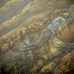
This settlement is situated among a number of old water-channels on the precipitous left bank of the Braefoot Linn, and about 200m W of Ericstane farmhouse (NT01SE 13). The monument has the appearance, particularly from the air (RCAHMSAP 1986), of a multivallate fort, but the settlement basically comprises a single bank and outer ditch.
Roughly D-shaped on plan with the chord of the D drawn along the steep N bank of the burn, the settlement measures about 66m from WNW to ESE by 40m internally; the enclosing arc of bank is probably a largely natural mound in origin, but it has been scarped on its inner and outer faces, and is surmounted by a wall which has been reduced to a stony bank up to 2.4m thick and 0.4m high. External facing-stones of this wall are visible on the W, NE and E, the last being on the S side of the entrance, which is about 2.5m wide and opens on to a partially-hollowed track which drops down to the gully on the NE. There is no evidence that either the bank or wall originally continued along the edge of the stream gully on the S. On the N, the bank is accompanied by a length of external ditch whivh links the natural gullies on the W and NE. An outer bank, also set on top of a natural bank, lies immediately the ditch on the N. On the NW, however, it departs from that line and swings out for a distance of about 15m before turning across an old stream channel to rest on the edge of the gully of the Braefoot Linn.
The interior of the settlement slopes gently from W to E, but has probably been levelled into the natural slope on the W. It contains the remains of at least three oval house-stances, measuring up to 9.5m in diameter, within rear scarps and front aprons, and a fourth, marked only by its arcing rear scarp.
Visited by RCAHMS (JRS, SMF), 26 February 1991.
Listed as defended settlement.
RCAHMS 1997.
Note (22 July 2015 - 18 May 2016)
The construction of this settlement above Ericstane has harnessed a series of natural channels on the N bank of the Braefoot Linn to create what is in effect a bivallate fortification, though as they appear today most of the features of the defences are largely natural. The interior of the settlement is D shaped on plan, its chord formed by the rocky cleft of Braefoot Linn on the S, and measures about 66m from ESE to WNW by 40m transversely (0.23ha). The inner bank appears to be some 8m in thickness, but is probably largely a scarped natural bank capped by a stone wall 2.4m in thickness by 0.4m in height; a few outer facing-stones are visible on the W and ENE. The ditch outside it is likewise tailored from one of the natural channels on the N, but where it cuts across their grain on the W is up to 10m in breadth by 2m in depth. A further 10m outside it on this side a second ditch with an internal bank has been cut to link the lip of the Braefoot Linn gully to a second channel on the N, though there is little evidence of artificial works extending eastwards, either in the channel itself or the rib separating it from the inner ditch. Indeed, the only evidence of artificial work in the channels around the NE flank is a short arc of bank where a trackway approaching the entrance from the N crosses the inner; the entrance into the interior itself lies on the E, the arrangement of the trackway thus exposing the visitor's right side. The interior has been dug into the slope on the W and contains at least four house platforms, the largest of which is about 9.5m in diameter.
Information from An Atlas of Hillforts of Great Britain and Ireland – 18 May 2016. Atlas of Hillforts SC3211

