 |
On-line Digital Images |
SC 791735 |
Papers of Professor John R Hume, economic and industrial historian, Glasgow, Scotland |
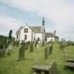
View from SSE showing S and parts of E fronts |
1979 |
Item Level |
|
 |
On-line Digital Images |
SC 1917404 |
Records of the Royal Commission on the Ancient and Historical Monuments of Scotland (RCAHMS), Edinbu |
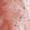
Upper Annandale landscape case-study area: map showing the medieval and later monuments, and the lands of the estates of Crunzierton in 1361 and Dumgree in 1605. Published in Eastern Dumfriesshire: an archaeological landscape. |
1996 |
Item Level |
|
 |
On-line Digital Images |
SC 1917793 |
Records of the Royal Commission on the Ancient and Historical Monuments of Scotland (RCAHMS), Edinbu |
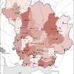
Map showing the distribution of medieval parish churches (named) in Annandale and Eskdale, against the pattern of parish boundaries at the present day. Published in Eastern Dumfriesshire: an archaeological landscape. |
1996 |
Item Level |
|
 |
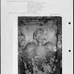
On-line Digital Images |
SC 2226927 |
Papers of Betty Willsher, historian, St Andrews, Scotland |
Photographs and research notes relating to graveyard monuments in Kirkpatrick Juxta Churchyard, Dumfries. |
|
Item Level |
|
 |
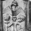
On-line Digital Images |
SC 2226928 |
Papers of Betty Willsher, historian, St Andrews, Scotland |
Photographs and research notes relating to graveyard monuments in Kirkpatrick Juxta Churchyard, Dumfries. |
|
Item Level |
|
 |
On-line Digital Images |
SC 2435541 |
Records of the Ordnance Survey, Southampton, Hampshire, England |
Kirkpatrick-Juxta, Saint Patrick's Church, NT00SE 60, Ordnance Survey index card, Recto |
1958 |
Item Level |
|
 |
On-line Digital Images |
SC 2498794 |
|
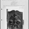
View of John Imrie's gravestone. |
|
Item Level |
|


