
Pricing Change
New pricing for orders of material from this site will come into place shortly. Charges for supply of digital images, digitisation on demand, prints and licensing will be altered.
Beattock Hill


Fort (Prehistoric)
Site Name Beattock Hill
Classification Fort (Prehistoric)
Canmore ID 48414
Site Number NT00SE 5
NGR NT 0657 0209
Datum OSGB36 - NGR
Permalink http://canmore.org.uk/site/48414


- Council Dumfries And Galloway
- Parish Kirkpatrick-juxta
- Former Region Dumfries And Galloway
- Former District Annandale And Eskdale
- Former County Dumfries-shire
NT00SE 5 0657 0209
(NT 0657 0209) Camp (NR)
OS 6" map (1957).
For unenclosed settlement (adjacent to S), see NT00SE 34.
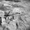
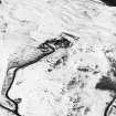
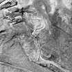
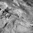
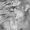
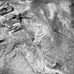
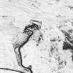
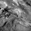
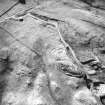
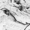
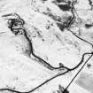
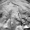
The fort on the summit of Beattock Hill consists of a massive, but now ruinous stone wall, enclosing an oval area 213 ft (64.9m) N-S by 100' (30.5m) transversely. Towards the N end, an oval flat-topped rock outcrop has formed a citadel, at the base of which, on SE, there is a trench-like hollow, probably natural. The entrance, in the S, is protected by a length of rampart or wall with an external quarry ditch, and another covers the N end. Much wall debris litters the slopes.
RCAHMS 1920, visited 1912; R W Feachem 1963.
An oval bivallate fort with an internal quarry ditch on the SE, measuring internally 72.0m N-S by 30.5m within the remains of a stone wall up to 3.5m wide, where double-faced. The outer ditch has been constructed around the base of the hill on the E, but on the W steep slopes provide adequate defence. The entrance is on the SW. The fort interior has been sub-divided on the NE by a secondary rock-cut ditch which cuts through the rampart on the E and encloses an area about 42.0m N-S by 18.5m. Possible house sites were noted in the southern part of the interior.
Resurveyed at 1/2500.
Visited by OS (D W R) 18 September 1973.
No change to previous field report.
Visited by OS (T R G) 22 September 1978.
Scheduled (with NT00SE 34) as 'Beattock Hill, fort and unenclosed settlement 935m W of Braeside...'
Information from Historic Scotland, scheduling document dated 26 March 2011.
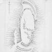
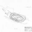
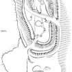
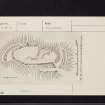
Measured Survey (23 October 1990)
RCAHMS surveyed the fort at Beattock Hill on 23 October 1990 with plane-table and self-reducing alidade at a scale of 1:500. The plan was redrawn in ink and published at a scale of 1:1000 (RCAHMS 1997, Fig. 59).
Note (1997)
NT 0657 0209 NT00SE 5
Listed as fort. Overlain by building.
RCAHMS 1997.
Note (22 July 2015 - 18 May 2016)
This fort is situated on a ridge of hard rock that makes up one of the summits of Beattock Hill. Roughly oval on plan, its defences comprise a thick stone rampart extending around the summit area, and an outer rampart with an external ditch encircling the foot of the ridge from 3m to 14m outside the inner line and traceable everywhere except along the edge of the old quarry (now back-filled) on the W. The relationship between the two lines of defence is not known, but they are both pierced by entrances on the E and SW, the former with staggered gaps utilising a natural gully that extends diagonally across the fort, thus exposing the visitor's left side, and the latter a more direct approach with evidence of some wear in the mouth of the outer gap. The rocky interior measures about 70m from N to S by 25m transversely and its S half contains a hut-circle with a stony bank, an unusual feature in forts in this area and perhaps associated with the unenclosed settlement of at least four round-houses immediately outside the ramparts on the S; a rectangular stone pen stands on the NE side of the interior adjacent to the inner rampart.
Information from An Atlas of Hillforts of Great Britain and Ireland – 18 May 2016. Atlas of Hillforts SC3208

