
Pricing Change
New pricing for orders of material from this site will come into place shortly. Charges for supply of digital images, digitisation on demand, prints and licensing will be altered.
Beattock Hill


Building (Medieval) - (Post Medieval), Settlement (Iron Age)
Site Name Beattock Hill
Classification Building (Medieval) - (Post Medieval), Settlement (Iron Age)
Alternative Name(s) Hillside Cottages
Canmore ID 48402
Site Number NT00SE 4
NGR NT 06637 02547
Datum OSGB36 - NGR
Permalink http://canmore.org.uk/site/48402


- Council Dumfries And Galloway
- Parish Kirkpatrick-juxta
- Former Region Dumfries And Galloway
- Former District Annandale And Eskdale
- Former County Dumfries-shire
NT00SE 4 0664 0254
(NT 0664 0254) Earthwork (NR)
OS 6" map, (1957)
The lower course of the stone wall, 7 - 9' thick, of a fort, 140' by 90', remains. Entrance has been from the W. Against the wall at the N end are the foundations of a rectangular building 18' by 12', with a small circular or apsidal structure at either end. That at the E end has the appearance of a beehive hut.
RCAHMS 1920, visited 1912.
A stone-walled enclosure, measuring 39.0m NW-SE by 29.5m, within a double-faced rubble wall up to 3.5m wide. A single outer wall-face is visible for most of the circumference, and an occasional inner, but
the spread rubble core conceals further details. The entrance on the W has been cleared out, and is 2.6m wide. The alleged rectangular building within the interior on the N, could not be identified, but at the S end of the enclosure is a levelled platform which could have supported houses. The non-defensive position, the construction and possible house sites, are indicative of a settlement.
Resurveyed at 1/2500.
Visited by OS (D W R) 4 September 1973
No change to previous field report.
See plan.
Visited by OS (T R G) 22 September 1978
Scheduled as 'Beattock Hill, settlement 700m W of Hillside Cottages... the remains of an enclosed settlement... visible as upstanding earthworks and stone wall footings.'
Information from Historic Scotland, scheduling document dated 15 March 2004.
Measured Survey (8 October 1990)
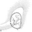
RCAHMS surveyed the settlement at Beattock Hill on 8 October 1990 with plane-table and self-reducing alidade at a scale of 1:500. The plan was redrawn in ink and published at a scale of 1:1000 (RCAHMS 1997, Fig. 60).
Field Visit (8 October 1990)
NT 0664 0254 NT00SE 4
This roughly oval settlement is situated on the W-facing slope of a low spur which projects from the N flank of Beattock Hill. It measures 40m from N to S by 25m transversely within a stone wall which has been reduced to a spread of rubble up to 12m thick and 0.5m high. However, where inner and outer facing-stones are visible, the original thickness of the wall is between 3m and 3.5m. The entrance gap (2.5m wide) is on the W where a natural rocky hollow provides access to the interior. A second gap, on the SE, is probably of comparatively recent date.
Situated within the SE quadrant of the settlement and on the highest part of the interior, there are the remains of a hut-circle which measures about 8m in diameter within a low, grass-grown bank up to 2.5m thick and 0.2m high. The bank is overlain on the SE by tumble from the settlement wall, and the position of the entrance is indicated by a broad, shallow depression on the SW. A second house-site lies at the N end of the interior and is marked by a shallow ring-ditch, measuring up to 9m in overall diameter and 2.8m in breadth, with an entrance on the W.
Situated partially within the settlement on the N, but also overlying wall tumble, there are the remains of a subrectangular building. It measures about 11m by 5m over low wall-footings and may be contemporary with two low stony banks which ascend towards the settlement wall from the W and NW respectively, and also overly tumble.
Visited by RCAHMS (JRS), 8 October 1990.
Listed as settlement. Overlain by building.
RCAHMS 1997.

