
Pricing Change
New pricing for orders of material from this site will come into place shortly. Charges for supply of digital images, digitisation on demand, prints and licensing will be altered.
Beattock, Barnhill


Temporary Camp (Roman)
Site Name Beattock, Barnhill
Classification Temporary Camp (Roman)
Alternative Name(s) Barnhill, Beattock 1
Canmore ID 48381
Site Number NT00SE 20
NGR NT 08985 02733
NGR Description Centred NT 0880 2720
Datum OSGB36 - NGR
Permalink http://canmore.org.uk/site/48381


- Council Dumfries And Galloway
- Parish Kirkpatrick-juxta
- Former Region Dumfries And Galloway
- Former District Annandale And Eskdale
- Former County Dumfries-shire
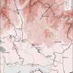
NT00SE 20 centred 08985 02733
(NT 0880 0270) ROMAN CAMP (R) (Site of)
OS 6" map, (1957)
See also NT00SE 45.
Crop marks of the W ditch, with gateway and tutulus, the NW angle, and the E side of a marching camp were seen from the air in 1945-6. There was no trace on the ground when visited in August 1946. The S side has apparently been eroded by the river and the surviving area is some 900 ft by 575 ft.
Site surveyed at 1:2500 scale.
S N Miller 1952
Survey of the complex of camps at Beattock has confirmed that the interpretation of the structures on the E side of the Roman road as a large camp enclosing an elongated secondary work was correct. The crop-mark of a traverse lying a little distance to the N of the field boundary that masks the N side of the original camp confirmed the presence of an entrance about 150m E of the NW angle; this would divide the N side in a ratio about 2 to 1, which implies that the camp faced W, and the E and W entrances, previously noted, were centrally situated in their respective sides. The area of the camp, on this assumption would be about 15 ha (37 acres).
G S Maxwell and D R Wilson 1987.
Excavations were carried out on one of a group of Roman camps near Beattock, previously identified from oblique aerial photographs. The excavations preceded the emplacement of the North West Ethylene Pipeline. This involved the excavation of two adjacent trenches over the northern ditch of the Roman camp. The information from the two trenches shows a sequence of deposition events.
The earliest anthropogenic activity on the site is represented by two pits. One of these was immediately S of the ditch cut while the other was truncated by the ditch. They pre-date the ditch and may, therefore, be pre-Roman. The remarkable correspondence between their location and that of the later ditch does, however, suggest that they may relate to some feature, perhaps a land division or a settlement area, on which the Roman camp was aligned.
The ditch of the Roman camp was c2m wide (N-S) with a maximum depth of over 1m. The sides slope at c45 degrees to a rounded bottom. Traces of the accompanying rampart were recorded on the S (interior) side of the ditch. These had been levelled and spread by ploughing. The primary fill of the ditch seems to represent collapse of the natural sand and gravel through which the ditch was cut. This would probably have happened as a result of collapse of the ditch edges shortly after its excavation. A regular stone slignment was set on this primary fill, along the base of the ditch. The stones are consistently larger than those naturally occurring in the subsoil, and their regular, linear arrangement precludes their being tumble from a rampart kerb. They are provisionally interpreted as a defensive feature but it is difficult to provide any convincing interpretation of their function on the evidence available.
The upper ditch fills were probably in place before the construction of the adjacent drystone dyke which runs parallel to the ditch on its N side. The presence of quantities of stone in these upper fills suggests, however, that periodic rebuilding and collapse of the adjacent field boundary may have occurred during the accumulation of these deposits. Stones present in the upper fills may alternatively have derived from field clearance in adjacent land.
An intensive watching brief carried out during pipeline construction found no traces of either internal features or the southern boundary of the camp. The latter has probably been removed by erosion from the Evan Water. No artefactual material was located.
An archive report of fieldwork results has been deposited with the NMRS, and a publication report is in preparation.
CFA 1992.
Aerial Photographic Interpretation (20 February 1996)
NT 089 027 NT00SE 20
Cropmarks on air photographs have revealed a semi-circular arc of ditch within the NW quadrant of this large Roman temporary camp, some 250m SW of Barnhill House (NT00SE 130). The ditch is fairly narrow and the arc has a diameter of about 80m.
Information from RCAHMS (SPH), 20 February 1996.
Barnhill. Listed as settlement within Roman temporary camp.
RCAHMS 1997.
Publication Account (17 December 2011)
On the gravel terrace at Beattock, about 1km to the north of the fort at Milton, lie some five temporary camps, on either side of the Evan Water, close to its confluence with the River Annan.
Beattock Bankend, the single camp currently known on the south side of the Water, was first discovered in 1977 by RCA HMS from the air (Maxwell and Wilson 1987: 30–1). At least 444m of the south-west side has been recorded as a cropmark, together with a rounded corner angle and 368m of the north-west side. The area enclosed by the camp is unclear – it lies on the southwest side of the Evan Water, which has clearly moved course over time, evidenced by cropmarks of numerous palaeo-channels. Both sides possess Stracathro-type gates; that in the north-west side lies less than 100m from the present course of the Water (but 330m from the known corner of the camp), and therefore the camp must have extended into the area now on the other (Barnhill) side of the river. If the gate on the south-west side is in the centre of that side, then the camp would have measured some 580m by at least 370m, enclosing at least 21.5ha (53acres) and quite possibly closer to 26ha (64 acres).
Excavations revealed that the ditch was up to 2m wide and 0.9m deep (Leslie 1995: 154; Speller and Leslie 1995: 19–20). One field oven and the probable remains of two more were located in a trench placed obliquely across the camp in advance of the upgrading of the A74. In addition, the excavators suggested, on the basis of the silting, that the camp perimeter was left open for a period of time before the rampart was pushed into the ditch. There was no evidence for any reuse of the ditch (Speller and Leslie 1995: 26). Leslie has suggested that this camp may be a construction camp for the nearby fort at Milton (1995: 150–2; Speller and Leslie 1995: 26–7), but this seems unlikely given the distance between the two and the fact that there is a camp just outside that fort (Milton I).
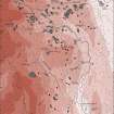
On the north side of the Evan Water lie a further four camps at Beattock Barnhill. Camp I, on the west, was first recorded through cropmarks in 1957 by St Joseph from the air (1958: 89). The camp measures 363m from north-west to south-east by about 304m transversely. Although the west side of the camp has been eroded by the movement of the Evan Water, the south corner is visible, giving us an indication of the likely position of this side. The camp enclosed about 11.7ha (almost 29 acres). A titulus is recorded in the ENE side, at a change of alignment just south of the centre. At its northern corner the camp overlies a putative fortlet. Maxwell undertook a trial excavation to establish the relationship between the two structures and demonstrated that the camp was the later of the two (Frere 1985a: 267; Maxwell and Wilson 1987: 31, 40).
East of camp I lie camps II, III and IV, which represent successive uses of the same location with the perimeters adjusted to suit the size of the force camped within. First photographed in 1945 by St Joseph from the air (1951:58), the camps are recorded as cropmarks with a field boundary running along their northern edge. Camp II measures 436m from WSW to ENE by at least 307m, but the south side of the camp is unknown, owing to erosion and movement of the Evan Water. Tituli are visible on the NNW and ENE sides, with a further two visible on the WSW side (although it is likely that northern titulus on this side relates to the occupation of camp IV). If the southern of the two tituli on the WSW side and the corresponding titulus on the ENE side are in the centre of those sides, then the camp would measure c 350m by 436m and enclose some 15.4ha (38 acres).
Excavations in 1992 on the north side of the camp recorded that the ditch was up to 2m wide and 0.8m deep with a U-shaped profile. Traces of rampart material were also noted (Neighbour et al 1994: 10–11). The camp has been reduced twice, but the small-scale excavations on the north side did not record any evidence for a recut of the ditch (Neighbour et al 1994).
Camp III represents a reduction of camp II by the construction of an additional defensive ditch (and presumably also rampart) some 115m from the WSW side of that camp. As with camp II, its southern extent is unknown. The camp measured 321m from WSW to ENE by at least 307m transversely, enclosing at least 10.2ha (25acres) and possibly 11.4ha (28 acres). (This assumes that the area enclosed by this camp was the larger area to the east, not the narrow rectangular area to the west, which would therefore represent an enclosed area of some 3.7ha (9 acres). A further use of the west rectangle is recorded(camp IV).) No additional gates of the camp are known, but it may have utilised the same entrances as those currently known on the NNW and ENE sides of camp II.
Camp IV is a reduction of camps II and III by the construction of an additional ditch (and presumably rampart) further reducing the area between the WSW sides of camps II and III. The area enclosed is almost square, measuring 124m from NN W to SSE by 118m, enclosing 1.4ha (3.6 acres). A titulus is visible in the centre of the WSW side but there is no corresponding break in the perimeter ditch. It is presumed that the earlier camp ditch was deliberately filled in at the entrance point, but possibly with similar material to that which later filled the rest of the ditch, thereby leaving the causeway undetectable in the cropmark record.
A study of the environmental history, fluvial deposits and river movement of the Evan Water concluded that the Stracathro-type camp at Beattock Bankend was earlier than its neighbours across the water at Beattock Barnhill. This was because the eastern Barnhill camps (II –IV) were constructed across gravel deposits and palaeo-channels that can only have been formed after the Bankend site was constructed (Tipping 1997: 25). Beattock Bankend is probably Flavian in date (see Chapter 10), and the fortlet underneath Beattock Barnhill I has also been proposed as dating to the 1st century ad (Maxwell and Wilson 1987: 21), thereby implying that Beattock Barnhill I was Antonine or later. A sequence can therefore be identified at this complex, with Beattock Bankend representing a Flavian occupation of the area and quite probably all four at Beattock Barnhill relating to campaigns in the Antonine and later periods. Their location a short distance from the fort at Milton, which demonstrated occupation in the Flavian and Antonine periods (Clarke 1951), suggests that non-proximity of camp and fort sites need not necessarily be an indicator of non-contemporaneity.
R H Jones 2011

