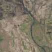
 |
On-line Digital Images |
SC 381726 |
|
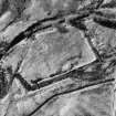
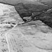
RECTILINEAR
Aerial view. |
|
Item Level |
|
 |
On-line Digital Images |
SC 382035 |
Records of the Royal Commission on the Ancient and Historical Monuments of Scotland (RCAHMS), Edinbu |
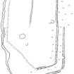
Publication drawing; Plan of Garpol Water moated site. |
14/3/1995 |
Item Level |
|
 |
On-line Digital Images |
SC 1346072 |
Records of the Royal Commission on the Ancient and Historical Monuments of Scotland (RCAHMS), Edinbu |
Survey drawing; Garpol Water enclosure. |
14/5/1990 |
Item Level |
|
 |
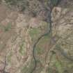
On-line Digital Images |
DP 275806 |
Historic Environment Scotland |
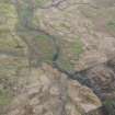
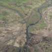
Oblique aerial view. |
24/4/2018 |
Item Level |
|
 |
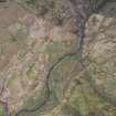
On-line Digital Images |
DP 275808 |
Historic Environment Scotland |
Oblique aerial view. |
24/4/2018 |
Item Level |
|
 |
On-line Digital Images |
DP 275810 |
Historic Environment Scotland |
Oblique aerial view. |
24/4/2018 |
Item Level |
|
 |
On-line Digital Images |
DP 275811 |
Historic Environment Scotland |
Oblique aerial view. |
24/4/2018 |
Item Level |
|
 |
On-line Digital Images |
DP 275813 |
Historic Environment Scotland |
Oblique aerial view. |
24/4/2018 |
Item Level |
|
 |
On-line Digital Images |
DP 275814 |
Historic Environment Scotland |
Oblique aerial view. |
24/4/2018 |
Item Level |
|
 |
On-line Digital Images |
DP 275815 |
Historic Environment Scotland |
Oblique aerial view. |
24/4/2018 |
Item Level |
|
 |
On-line Digital Images |
DP 275816 |
Historic Environment Scotland |
Oblique aerial view. |
24/4/2018 |
Item Level |
|
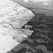
 |
On-line Digital Images |
SC 1729539 |
RCAHMS Aerial Photography |
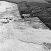
RECTILINEAR
Aerial view |
1988 |
Item Level |
|
 |
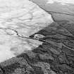
On-line Digital Images |
SC 1729540 |
RCAHMS Aerial Photography |
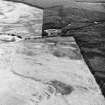
RECTILINEAR
Aerial view |
1988 |
Item Level |
|
 |
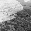
On-line Digital Images |
SC 1729541 |
RCAHMS Aerial Photography |
RECTILINEAR
Aerial view. |
1988 |
Item Level |
|
 |
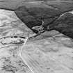
On-line Digital Images |
SC 1729623 |
RCAHMS Aerial Photography |
Aerial view. |
1991 |
Item Level |
|
 |
On-line Digital Images |
SC 1729624 |
RCAHMS Aerial Photography |
Aerial view. |
1991 |
Item Level |
|
 |
On-line Digital Images |
SC 1729664 |
RCAHMS Aerial Photography |
Aerial view. |
1991 |
Item Level |
|
 |
On-line Digital Images |
SC 1729665 |
RCAHMS Aerial Photography |
Aerial view. |
1991 |
Item Level |
|
 |
On-line Digital Images |
SC 1729666 |
RCAHMS Aerial Photography |
Aerial view. |
1991 |
Item Level |
|
 |
On-line Digital Images |
SC 1729667 |
RCAHMS Aerial Photography |
Aerial view |
1991 |
Item Level |
|
 |
On-line Digital Images |
SC 1729668 |
RCAHMS Aerial Photography |
Aerial view. |
1991 |
Item Level |
|
 |
On-line Digital Images |
SC 1729669 |
RCAHMS Aerial Photography |
Aerial view. |
1991 |
Item Level |
|
 |
On-line Digital Images |
SC 1729670 |
RCAHMS Aerial Photography |
Aerial view. |
1991 |
Item Level |
|
 |
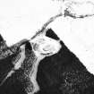
On-line Digital Images |
SC 1917404 |
Records of the Royal Commission on the Ancient and Historical Monuments of Scotland (RCAHMS), Edinbu |
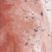
Upper Annandale landscape case-study area: map showing the medieval and later monuments, and the lands of the estates of Crunzierton in 1361 and Dumgree in 1605. Published in Eastern Dumfriesshire: an archaeological landscape. |
1996 |
Item Level |
|


