
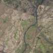
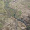
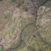
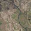
Garpol Water


Motte And Bailey (Medieval)
Site Name Garpol Water
Classification Motte And Bailey (Medieval)
Canmore ID 48369
Site Number NT00SE 1
NGR NT 0505 0402
Datum OSGB36 - NGR
Permalink http://canmore.org.uk/site/48369


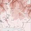


- Council Dumfries And Galloway
- Parish Kirkpatrick-juxta
- Former Region Dumfries And Galloway
- Former District Annandale And Eskdale
- Former County Dumfries-shire
NT00SE 1 0505 0402.
(NT 0505 0402) Mote and Bailey (NR)
OS 6"map, (1957)
For successor Auchen Castle (NT 0632 0350), see NT00SE 3.00. Not to be confused with Garpol Water, moated site, (NT 0529 0396), for which see NT00SE 2.
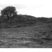
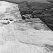
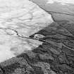
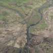
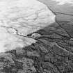
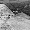
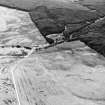
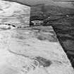
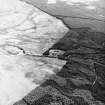
A prominent flat-topped hillock fashioned into a motte on a lower bailey platform, and surrounded by a deep trench and outer mound. Encircling the motte some 7' above the bottom of the trench is a stone-parapeted terrace, 5' wide except on the NE, where it broadens to form a small base court.
RCAHMS 1920, Visited 1912
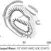
This motte and bailey is generally as planned by RCAHMS. The summit of the motte measures 30.5m NW-SE by 11.5m and the base-court measures 36.0m NW-SE by 14.0m.
Resurveyed at 1/2500.
Visited by OS (D W R) 18 September 1973
No change to previous field report.
Visited by OS (T R G) 22 September 1978
Field Visit (15 March 1990)
NT 0505 0402 NT00SE 1
(Also classified as settlement). This motte-and-bailey castle has been fashioned from a natural hillock. The highest point of the hillock has been dressed to form an elongated motte, its level summit measuring 32.5m from NNW to SSE by 10.8m transversely, whilst a terrace on the N, 10m below the summit of the motte, has been utilised to create a bailey measuring 33.9m from WNW to ESE by 13.8m transversely. On the E, S and W, at the level of the bailey, the motte is enclosed by a stony bank 2.2m thick and 0.8m high. Around the base of both the motte and the bailey, on the N, W and SW, there is a ditch 6m broad and 2m deep accompanied by an external bank 4m thick and 1.5m high; the purpose of a break in the bank on the N, 11m broad, is unclear.
Visited by RCAHMS (PC), 15 May 1990.
(RCAHMS 1920)
Listed as motte-and-bailey.
RCAHMS 1997.
Measured Survey (15 May 1990)
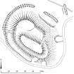
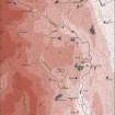
RCAHMS surveyed the motte and bailey at Garpol Water on 15 May 1990 with plane-table and self-reducing alidade at a scale of 1:500. The plan was redrawn in ink and published at a scale of 1:1000 (RCAHMS 1997, Fig. 207). An inked version was also produced and published at a scale of 1:2500 alongside comparative plans of mottes and medieval earthwork monuments (RCAHMS 1997, Fig. 202).

