
Pricing Change
New pricing for orders of material from this site will come into place shortly. Charges for supply of digital images, digitisation on demand, prints and licensing will be altered.
Mellingshaw Tower


Rig And Furrow (Medieval) - (Post Medieval), Tower House (Medieval)
Site Name Mellingshaw Tower
Classification Rig And Furrow (Medieval) - (Post Medieval), Tower House (Medieval)
Alternative Name(s) Malynshaw; Mallingshaw; Mellingshaws
Canmore ID 48359
Site Number NT00NW 1
NGR NT 0365 0879
Datum OSGB36 - NGR
Permalink http://canmore.org.uk/site/48359


- Council Dumfries And Galloway
- Parish Moffat
- Former Region Dumfries And Galloway
- Former District Annandale And Eskdale
- Former County Dumfries-shire
NT 0365 0879 NT00NW 1
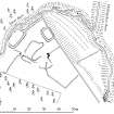
This late 16th-century tower-house is situated on a terrace at the head of rising ground overlooking a gorge of the Mellingshaw Burn. All that remains visible of the tower is a portion of a stair-wing and the turf-covered outline of its barmkin and outbuildings. The tower, which stood at least three storeys in height, seems to have been of T-plan type, with an entrance-doorway in the NNE re-entrant angle between the main block and the wing. This much is clear from the surviving fragment of masonry, the ENE wall and ESE angle of the wing (2.6m from NNW to SSE by 1.8m transversely over a wall 0.7m thick and up to 5.5m high). There is a slit-window at ground-floor level, a second-floor window (wrought with an 80mm chamfered arris and originally barred), and, to the interior, in the ENE jamb of the doorway, a draw-bar slot, and the cut-back treads of a newel-stair rising to third-floor level. From surface traces and a scooped depression to the WSW of the wing, the main block would seem to have measured about 8.6m from NNW to SSE by 6m transversely overall. The barmkin, reduced on the W to a low bank up to 3.6m thick and 0.6m high, extended around the NW side of the tower.
To the interior, on the NW and NNE, there are the turf-covered remains of two buildings measuring respectively 14.5m from SW to NE by at least 5m, and 8.7m from NNW to SSE by 7.3m transversely overall. On the NE there are traces of rig-and-furrow cultivation.
In the 16th century Mellingshaw was the property of the Johnstones.
Visited by RCAHMS (IMS/PC), 4 September 1990.
(RCAHMS 1920).
Listed as tower.
RCAHMS 1997.
NT00NW 1 0365 0879.
(NT 0365 0879) Mellingshaw Tower (NR)
(remains of)
OS 6" map, (1962)
Little now remains of Mellingshaw Tower, except the SE angle containing a small wheel-stair. This wall, in which is one jamb of the door, stands 15' high at the angle, and is 8'6" long by 2'4" thick. There is now no evidence to show the form or extent of the tower. It belonged to a branch of the Johnstones, as "Malynshaw" or "Mallingshaw" in the 16th century.
RCAHMS 1920, visited 1912
The remains of Mellingshaw Tower are as described, there being no traces of the remainder of the building.
The remains of an earth-and-stone bank form two sides of an enclosure or courtyard on the NW side of the fragment of Mellingshaw. The bank, or rubble of a wall, is spread to 3.0m and is 0.3m high. It runs close to the burnside on the N for some 32.0m from a stone dyke, and at its W extremity the foundations of a house (14.0m x 3.8m) abut it on the N or burn side. A gap of 3.0m occurs here, and then a fragment of bank runs SSE for 0.18m ending in mutilation 12.0m W of the ruin. Another rectangular structure (8.0m x 3.4m) abuts the stone dyke on the E. It is possible that these features are contemporary with Mellingshaw, but they could be the remains of a later farmstead. The architectural details of the fragment of the building suggest a 17th century date.
Visited by OS (J L D) 10 May 1959
No change to previous report
Resurveyed at 1:2500.
Visited by OS (D W R) 25 September 1973
Measured Survey (24 September 1990 - 25 September 1990)
RCAHMS surveyed Mellingshaw Tower between 24-25 September 1990 with plane-table and self-reducing alidade at a scale of 1:500. A detail of the remains of the ground-floor of the tower was also produced at a scale 1:100. The site plan was redrawn in ink and published at a scale of 1:1000 (RCAHMS 1997, Fig. 230).

