
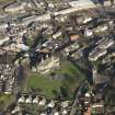
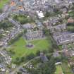
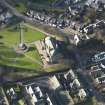
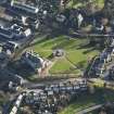
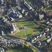
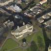
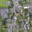
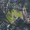
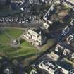
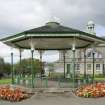
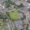
Bo'ness, School Brae, Glebe Park, Bandstand


Bandstand (20th Century)
Site Name Bo'ness, School Brae, Glebe Park, Bandstand
Classification Bandstand (20th Century)
Alternative Name(s) Braehead; Stewart Avenue
Canmore ID 48147
Site Number NS98SE 26
NGR NS 99826 81430
Datum OSGB36 - NGR
Permalink http://canmore.org.uk/site/48147


- Council Falkirk
- Parish Bo'ness And Carriden
- Former Region Central
- Former District Falkirk
- Former County West Lothian
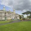
Walter McFarlane & Co Saracen Foundry, 1902. Cast-iron octagonal bandstand on stone base, deeper to N to accommodate sloping site. Slim columns with brackets with ornate tracery incorporating lute motif. Timber canopy with decorative band round circumference. Grey slate roof with airy delicate crown with spire. (Historic Environment Scotland List Entry)
Characterisation
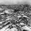
This site falls within the School Brae Area of Townscape Character (NS98SE 208), which was defined as part of the RCAHMS Urban Survey Programme 2013. Text relating to the historical development and topography, and present character of the School Brae Area of Townscape Character can be viewed at site NS98SE 208.
Information from RCAHMS (LK), January 2014

