
Following the launch of trove.scot in February 2025 we are now planning the retiral of some of our webservices. Canmore will be switched off on 24th June 2025. Information about the closure can be found on the HES website: Retiral of HES web services | Historic Environment Scotland
Carribber Castle


Castle (Medieval)
Site Name Carribber Castle
Classification Castle (Medieval)
Alternative Name(s) Carriber Castle; Rob Gibb's Castle
Canmore ID 47851
Site Number NS97NE 7
NGR NS 96574 75162
Datum OSGB36 - NGR
Permalink http://canmore.org.uk/site/47851


- Council West Lothian
- Parish Linlithgow
- Former Region Lothian
- Former District West Lothian
- Former County West Lothian
NS97NE 7 96574 75162
(NS 9657 7516) Rob Gibb's or Carribber Castle (NR) (Remains of)
OS 6" map (1958)
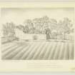
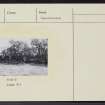
"Robert Gib of Carribers" was the Queen's principal baillie of the port of Newhaven in 1553. The fragmentary remains of his house stand on the right bank of the steep Carribber Glen. At the N end there seems to have been a square courtyard, now covered with vegetation, with an oblong block on the N and S sides. The only feature is a chamfered doorway in the W wall which seems no earlier than the 17th century S of the courtyard there has been an oblong range, probably stabling or byres. The remaining walls are only 2 1/2' thick, built of rubble and average 8' in height, but in places stand much higher. The ruin appears to have been deliberately cast down and there are traces of recent digging within the courtyard.
RCAHMS 1929, visited 1926
Carribber Castle is a rather extensive establishment, with a number of small buildings, and courtyards. It does not appear to have been a place of strength as the walls do not exceed 1.0m in thickness. The outer wall at the NE end of the building, and which runs NW, seems to have curved somewhat towards the SW, as the track of a wall can be seen here, and this may denote the outer limits of the grounds. At the present day, the walls of the "castle" are overgrown with trees, and does not present a very striking ruin. The northernmost wall stands to the greatest height, and in it are traces of three windows. Elsewhere, the walls average 2.0m in height, save for the E wall which is only 0.3m high. It would appear to have been a residence of the late 16th or early 17th century, possibly a manor house.
Visited by OS (JLD) 20 December 1952
The overgrown remains of this building are generally as described.
Visited by OS (JP) 9 July 1974

