
Castlehill


Motte (Medieval)
Site Name Castlehill
Classification Motte (Medieval)
Canmore ID 47819
Site Number NS97NE 4
NGR NS 95748 75651
Datum OSGB36 - NGR
Permalink http://canmore.org.uk/site/47819


- Council Falkirk
- Parish Muiravonside
- Former Region Central
- Former District Falkirk
- Former County Stirlingshire
NS97NE 4 9575 7565.
(NS 9575 7565) Indeterminate Site, Castlehill: A natural mound, 230 yds S of Compston, measures 200' WNW-ESE by 150', and rises to a height of 15'. Its top is cut by a broad, shallow trench, of no great age and about 70' in length; immediately beyond the SW end of this there is a terrace which appears to have been formed as a spoil-heap from the cutting. No other recognisable traces of artificial work appear, but "an old fortification...called Castlehill near to the house of Compstone, where there are a great many vaults" is noted in 1723 (c/f NS97NE 22).
Visited by OS (JLD) 20 December 1953
W Macfarlane 1906; RCAHMS 1963, visited 1953
Field Visit (August 1977)
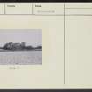
Castlehill NS 957 756 NS97NE 4
Probable motte now appearing as an oval mound measuring c. 32m by 27m on top and standing about 3m above surrounding river flood plain. Much field clearance material has been piled against side of mound, which also bears traces of excavation.
RCAHMS 1978, visited August 1977
(RCAHMS 1963, p. 449, no. 589)

