
Pricing Change
New pricing for orders of material from this site will come into place shortly. Charges for supply of digital images, digitisation on demand, prints and licensing will be altered.
Hyndford


Crannog (Iron Age), Roundhouse (Iron Age), Cup (Steatite)(Iron Age), Finger Ring(S) (Bronze)(Iron Age), Penannular Brooch(S) (Bronze)(Iron Age), Torc (Iron Age), Unidentified Pottery (Roman)
Site Name Hyndford
Classification Crannog (Iron Age), Roundhouse (Iron Age), Cup (Steatite)(Iron Age), Finger Ring(S) (Bronze)(Iron Age), Penannular Brooch(S) (Bronze)(Iron Age), Torc (Iron Age), Unidentified Pottery (Roman)
Alternative Name(s) River Clyde; Hyndford Bridge
Canmore ID 47687
Site Number NS94SW 10
NGR NS 9061 4187
Datum OSGB36 - NGR
Permalink http://canmore.org.uk/site/47687


- Council South Lanarkshire
- Parish Lanark
- Former Region Strathclyde
- Former District Clydesdale
- Former County Lanarkshire
NS94SW 10 9061 4187
Lake Dwelling [NAR]
OS 1:10,560 map, 1958.
(NS 9061 4187) Crannog (NR)
OS 1:10000 map (1978)
This crannog was in a similar condition to that described by the RCAHMS when seen in 1955 and 1968. Some fragments of samian ware and a few iron implements from it were noted in Lanark Museum in 1955.
Surveyed at 1:2500.
Visited by OS (JD) 30 March 1955 and (WDJ) 10 January 1968
Three bronze spiral finger-rings.
E J MacKie 1971
Site recorded during an archaeological evaluation conducted on 30 alternative route elements, with a combined length of c84km, for a proposed road linking the M8 near Whitburn, Lothian Region with the M6/M74 near Douglas, Clydesdale District.
NS94SW 10 Crannog
An illustrated report will be deposited with the NMRS.
Sponsor: Roads Directorate of The Scottish Office Industry Department, managed on its behalf by Historic Scotland.
A J Dunwell and R J Strachan 1995.
Field Visit (September 1971)
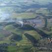
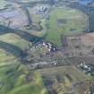
NS 906 418. The remains of this crannog are situated among trees 130m NNW of Hyndford. Formerly an artificial islet near the margin of a small loch, it now appears as a low, roughly circular mound measuring about 23m across and surrounded by a dry, ditch-like hollow, 0.8m in average depth, which varies in width from 4.0m on the N to as much as 12.0m on the SW. The following description is largely based on the published report of excavations on the site carried out in 1898 (Munro 1899).
The crannog was founded on a platform composed of a layer of brushwood laid directly on the bed of the loch and covered by a layer of fine clay, which formed the floor of a circular house measuring about 10.4m in diameter within a wall constructed on a framework of upright wooden posts. The posts were disposed somewhat irregularly in what appears to have been two, or possibly three, closely-set concentric rings, about 15m in diameter over all, with their stumps projecting up to 0.6m above the clay floor, and with their bases firmly lodged in the brushwood layer underneath. Although their primary function was to provide the outer framework for the house, they would also have served to consolidate the substructure. It should be noted that the limits of the excavation extended only a short distance outside the outer ring of posts, leaving a strip, between 3.0m and 4.5m wide, round the perimeter, which could not be fully investigated because of flooding.
Within the central area enclosed by the posts there were at least three hearths, each consisting of a roughly circular area of paving about 0.6m in diameter, surrounded by ashes. To counteract the gradual subsidence of the underlying brushwood foundation, the levels of both the floor and the hearths had been periodically raised, and one of the hearths had been rebuilt on two occasions.
A large quantity of ashes, charcoal and animal bones was discovered throughout the layer of a mixed debris, up to 0.9m deep, that had accumulated over the floor. A particularly heavy concentration of rubbish, situated partly within and partly outside the circle of piles on the SE probably represented the principal kitchen-midden. In addition, however, to this organic material, the site yielded a large assemblage of relics, now in the NMAS, comprising mainly objects of metal, glass, pottery and stone. The metal objects include a torc consisting of bronze beads strung on a thin iron rod; penannular bronze brooches; bronze finger-rings; iron axeheads; an iron spearhead; an iron wedge; an adze-shaped object and fragments of a flat circular band of iron. The glass objects include armlets or bracelets, melon beads, fragments of amber and green glass, a fragment of a pillar-moulded bowl, and pieces of glass bottle. The pottery comprises about forty sherds of plain and decorated samian ware, together with a few sherds of Roman coarse wares, including a mortarium, and some sherds of medieval wares. The stone objects include a fragment of a steatite cup; a small mortar; two polished discs, one circular, the other rectangular; a fragment of a mould; whorls of sandstone and shale; a grinder; a hammerstone; several whetstones; a polished axehead and part of another; a small jet ring and part of a second; part of a jet armlet; a perforated piece of shale; three roughly-shaped pieces of shale, possibly used for burnishing; and four small shale pebbles. Finally, there is part of a crucible, two pieces of iron-slag and seven small fragments of ruddle.
The importance of this collection lies not least in the presence of a number of objects of Roman manufacture, which may be dated to the end of the first century AD (Curle 1932, 381-3); these probably all came from the Roman fort at Castledykes (NS94SW 7), situated only 3km to the NE. Although the fort was re-occupied during the second century AD, no objects datable to the Antonine period were recovered from the crannog. This strongly suggests that the crannog fell into disuse at some time during the early part of the second century AD before the beginning of the Antonine occupation around AD 140.
RCAHMS 1978, visited September 1971.
Field Visit (May 2017)
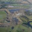
A sub-oval earthwork platform surrounded to the north, east and south by a steep sided ditch, 4m in width and up to 1.5m in depth, to the south west and west of the platform the ditch opens up into a much larger shallow depression up to 7m in width with more natural slope leading into the landscape beyond. The platform is 23m N-S, 21.5m E-W internally and 27.7m E-W externally, and up to 1.5m in height from the base of the surrounding ditch. The platform is covered by large mature trees and the surrounding area is covered in brambles and bracken. When visited in May 2017 the area was extremely dry, possibly as a result in the change in hydrology from the nearby quarry, suggesting that the archaeology would possibly be desiccated and being increasing damaged. The crannog has extensive views to the south and west, now partially blocked by the quarry.
Information from the Clyde and Avon Valley Landscape Partnership (Northlight Heritage), 2017

