Accessibility

Font Size

100% 150% 200%

Background Colour

Default Contrast
Close Reset

Balnakeil, Durness Parish Church

Church (Period Unassigned)

Site Name Balnakeil, Durness Parish Church

Classification Church (Period Unassigned)

Alternative Name(s) Balnakeil Church; Durness Old Parish Church; Durness, Old St Peter's Church; Clach Na Sagart Ruadh

Canmore ID 4768

Site Number NC36NE 1

NGR NC 39106 68663

Datum OSGB36 - NGR

Permalink http://canmore.org.uk/site/4768

Ordnance Survey licence number AC0000807262. All rights reserved.
Canmore Disclaimer. © Bluesky International Limited 2025. Public Sector Viewing Terms

Toggle Aerial | View on large map

Digital Images

General view
General view
View from high ground to SEView from SWWindow above main doorway on E gable, view from EDoorway on E side of N aisle, view from EInterior, view from EInterior, mural tomb, view from NInterior, mural tomb, view of tomb slabInterior, view of corner of N aisle and nave at E endMonument to Rod Doune (Robert Mackay), detail of marble plaquePlan and Profile of door jambOblique aerial view of Balnakeil Parish Church and Churchyard, looking to the E.Oblique aerial view of Balnakeil Parish Church and Churchyard, looking to the WNW.Monument to Rod Doune (Robert Mackay), detail of marble plaqueGeneral view from SouthGeneral view from high ground to SEEntrance to churchyard, view from SEInterior, mural tomb, view of tomb slabView from NEWindow on W gable, view from WDoorway on E side of N aisle, view from EOblique aerial view of Balnakeil House, Balnakeil Parish Church and Churchyard, looking to the N.Entrance to churchyard, detail of date inscribed jamb -1857View of East windowTombstone, 1619, in wall of churchMasonry detail at junction of North and East aislesView from high ground to SEView from NEView from SEView from NMain doorway on E gable, view from EBlocked window on S wall, view from SInterior, window above main doorway on E gable, view from WInterior, mural tomb, view of tomb slabInterior, detail of blocked window in S wall of naveMonument to Rob Doune (Robert Mackay), view from WMonument to Rod Doune (Robert Mackay), detail of marble plaqueEntrance to churchyard, view from SEInterior, window in N gable of N aisle, view from SOblique aerial view centred on Balnakeil House and Durness Parish Church, looking SSW.Oblique aerial view centred on Balnakeil House and Durness Parish Church, looking ESE.Oblique aerial view of Balnakeil Parish Church and Churchyard, looking to the ESE.View from WWindow on W gable, view from WBlocked doorway on S wall, detail of carved stone panel aboveWindow on W gable, view from WInterior, mural tomb, view from NInterior, detail of blocked doorway in S wall of naveBlocked doorway on S wall, view from SInterior, view from WInterior, detail of blocked doorway in S wall of naveMonument to Rob Doune (Robert Mackay), view from WOblique aerial view centred on Balnakeil House and Durness Parish Church, looking SE.Balnakeil, Durness Parish Church, NC36NE 1, Ordnance Survey index card, RectoView from SBlocked doorway on S wall, view from SInterior, window in N gable of N aisle, view from SInterior, detail of blocked window in S wall of naveMonument to Rod Doune (Robert Mackay), detail of marble plaqueView from NEInterior, window above main doorway on E gable, view from WInterior, detail of blocked window in S wall of naveGeneral oblique aerial view of Balnakeil Bay, centred on Balnakeil House and Durness Parish Church, looking NE.Oblique aerial view of Balnakeil Parish Church and Churchyard, looking to the E.Oblique aerial view of Balnakeil Parish Church and Churchyard with Balnakeil House beyond, looking to the ESE.Balnakeil, Durness Parish Church, NC36NE 1, Ordnance Survey index card, page number 1, RectoView from SWInterior, view from EInterior, view from WInterior, N aisle, E doorway, view from WInterior, detail of blocked window in W wall of N aisleGeneral view from high ground to SEView from SBlocked doorway on S wall, detail of carved stone panel aboveWindow on W gable, view from WInterior, N aisle, E doorway, view from WInterior, view of corner of N aisle and nave at W endOblique aerial view centred on Balnakeil House and Durness Parish Church, looking NW.Oblique aerial view of Balnakeil House, Balnakeil Parish Church and Churchyard, looking to the NNW.Oblique aerial view of Balnakeil House, Balnakeil Parish Church and Churchyard, looking to the WNW.Oblique aerial view of Balnakeil Parish Church and Churchyard, looking to the NE.Distant view from high ground to SEMonument to Rod Doune (Robert Mackay), detail of marble plaqueView from South WestBalnakeil, Durness Parish Church, NC36NE 1, Ordnance Survey index card, RectoInterior, N aisle, view from SMonument to Rob Doune (Robert Mackay), view from SMain doorway on E gable, view from EBlocked window on S wall, view from SInterior, N aisle, view from SInterior, window in W gable, view from EInterior, detail of blocked window in S wall of naveInterior, detail of blocked window in W wall of N aisleGeneral oblique aerial view of Durness Golf Course, looking to the W.Oblique aerial view of Balnakeil Parish Church and Churchyard, looking to the N.Distant view from SouthWindow above main doorway on E gable, view from EDetail of bellcoteInterior, main doorway on E gable, view from WInterior, mural tomb, detail of armorial panel

First 100 images shown. See the Collections panel (below) for a link to all digital images.

Administrative Areas

  • Council Highland
  • Parish Durness
  • Former Region Highland
  • Former District Sutherland
  • Former County Sutherland

Archaeology Notes

NC35NE 1.00 39106 68663

(NC 3911 6866) Church (NR) (remains of)

OS 6" map, (1962).

NC36NE 1.01 Centred NC 39090 68653 Churchyard

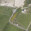
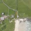
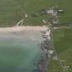
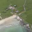
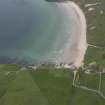
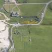
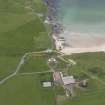
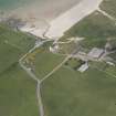
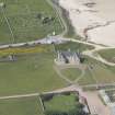
The remains of the former parish church which was built in 1619 and had an aisle added to the N in 1692. It was in use until about 1814 when the present church was built (at NC 4042 6693). Although somewhat irregular in plan, it is generally typical of its period with a belfry on the E gable. The remains stand to the wall-head, the crow-stepped gables being intact. The earliest reference occurs between 1223 and 1245 when it was assigned to find light and incense for the cathedral church ( ), but it is said to have been a Celtic foundation of St Maelrubba (6, 7 & 8). An old font known as the 'Clach na sagart ruadh' or 'stone of the red priest' (cf Applecross - NG74NW 1 - for association of St Maelrubha and 'the Red Priest'), lay in front of the door of Balnakiel House (NC36NE 4) before 1867 but by 1874 it had been moved to within the church. The church is said to occupy 'the site of a cell of Dornoch monastery' (? ), but there is no mention of such by Easson.

Visible on RAF air photographs CPE/Scot/UK 185: 1150-1: flown 1946.

Orig Paroch Scot 1855; J Horsburgh 1870; H Morrison 1883; D MacGibbon and T Ross 1897; RCAHMS 1911; A Mackay 1914; A B Scott 1918; D E Easson 1957.

What could be a former, circular, enclosing bank of the churchyard is visible on aerial photographs within the confines of the modern graveyard.

D E Easson 1957.

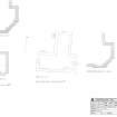
The church is well preserved, the walls of rubble masonry being 0.8m thick and averagine 2.3m in height. Externally, the nave measures 13.8m by 6.0m and the aisle 7.7m by 6.0m.

Visited by OS (W D J) 5 April 1960.

This church is as described and planned by MacGibbon and Ross. The font stands within the church and is covered by the top half of a rotary quern. There is no ground trace of the suggested circular graveyard wall.

Visited by OS (A A) 22 July 1971.

The church is as described by the previous authorities. The font has been removed by persons unknown in recent years. A holy water stoup, now cracked in half, lies immediately inside the church entrance on the S side.

Visited by OS (J B) 22 April 1980.

Scheduled as Durness Old Church, Balnakeil.

Information from Historic Scotland, scheduling document dated 9 October 2001.

References

MyCanmore Image Contributions


Contribute an Image

MyCanmore Text Contributions