
Couthally Castle


Castle (Medieval)
Site Name Couthally Castle
Classification Castle (Medieval)
Alternative Name(s) Couthalley Castle; Cowthally Castle
Canmore ID 47617
Site Number NS94NE 4
NGR NS 97116 48169
Datum OSGB36 - NGR
Permalink http://canmore.org.uk/site/47617


- Council South Lanarkshire
- Parish Carnwath
- Former Region Strathclyde
- Former District Clydesdale
- Former County Lanarkshire
NS94NE 4 97116 48169
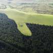
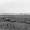
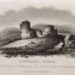
(NS 9711 4816) Couthalley Castle (NR) (Ruin)
(Centred : NS 9716 4818) Moat (NR) (Site of)
OS 6" map (1913)
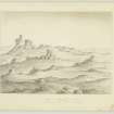
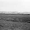
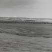
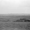
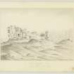
Couthalley Castle, mentioned in the middle of the 12th century, already needed rebuilding in 1375. It was further altered and extended in 1415 and 1524-8, at which time it comprised three towers, one on a barmkin wall c.4 yds high, and the other two of which had been added before 1526. The castle was besieged in 1557 and again rebuilt in 1586. The tower on the barmkin wall and the remains of the other two could still be seen about 1815.
New Statistical Account (NSA) 1845 (J Walker); G V Irving and A Murray 1864; J Somerville 1815; W M MacKenzie 1927; J Wilson 1936
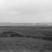
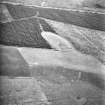
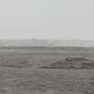
Couthalley Castle is an L-shaped tower, measuring 17.8m N-S by 21.5m E-W over walls about 1.8 to 2.0m thick, maximum height 2.8m. The lower courses of the two towers attached to the main building are still to be seen but it is impossible to identify the tower on the barmkin wall although the rectangular remains of buildings flanking the outer entrance are clearly visible.
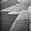
The 'Moat' published by OS (1913) is in fact three concentric ditches 5 to 7 metres in width but no more than 0.5m deep: all are waterlogged.
Surveyed at 1/2500.
Visited by OS (EGC) 9 January 1968
Photographed by the RCAHMS in 1980.
Field Visit (26 June 1943)
This site was included within the RCAHMS Emergency Survey (1942-3), an unpublished rescue project. Site descriptions, organised by county, vary from short notes to lengthy and full descriptions and are available to view online with contemporary sketches and photographs. The original typescripts, manuscripts, notebooks and photographs can also be consulted in the RCAHMS Search Room.
Information from RCAHMS (GFG) 10 December 2014.

