
Carmichael House


Country House (18th Century)
Site Name Carmichael House
Classification Country House (18th Century)
Canmore ID 47516
Site Number NS93NW 12
NGR NS 93646 39019
Datum OSGB36 - NGR
Permalink http://canmore.org.uk/site/47516


- Council South Lanarkshire
- Parish Carmichael
- Former Region Strathclyde
- Former District Clydesdale
- Former County Lanarkshire
NS93NW 12.00 93646 39019
NS93NW 12.01 93816 38706 Formal Gardens (Curling Pond)
NS93NW 12.02 93248 38804 Dovecot
NS93NW 12.03 93951 39240 East Mains
NS93NW 12.04 93541 39105 Laundry Cottage
NS93NW 12.04 93551 39159 Cottage (Twin Cottages)
NS93NW 12.05 93529 39098 Wellhead
NS93NW 12.06 94311 39786 Gates
NS93NW 12.08 93303 39438 Monument
NS93NW 12.09 93220 38822 West Mains
NS93NW 12.10 c.935 390 Butler's Cottage
NS93MW 12.11 93578 39176 Cottage (Twin Cottages)
NS93NW 12.12 94601 37383 Mausoleum
NMRS REFERENCE
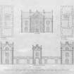
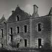
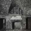
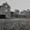
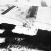
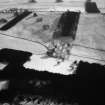
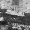
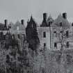
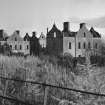
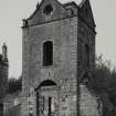
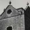
Built in the 18th century. Only the North and South wings of the original plans completed.
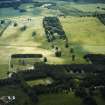
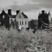
This Category B Listed building was demolished c. 1954.
Owner: Sir W.E.F. Carmichael-Anstruther.
EXTERNAL REFERENCE
Scottish Record Office
Tutorial Inventory of the Heritable and Moveable Estate of Sir John Carmichael Anstruther.
Household furniture and furnishing is listed room by room but without detail. The Mansionhouse appears to have been large with East and West wings, a gallery and a Russian room.
[The estate was part of the entailed property of John 3rd Earl of Hyndford (1701-1767). It reverted to Sir John Carmichael Anstruther in 1817]
1828 GD 146/27/2/12 (PLEASE NOTE THAT THIS IS A DEFECTIVE REFERENCE - INFORMATION FROM J GIFFORD 27 Jan 2009)
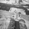
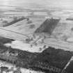
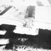
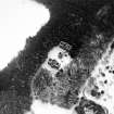
Roofless, since circa 1955 but otherwise substantially intact ruin of H plan country house, probably built for John, 3rd Earl of Hyndford. Main accommodation in 2-storey and attic end ranges, single-storey link range with 2-storey and attic tower. Purple sandstone rubble with cream sandstone dressings.
Plan form unique in Scotland, due to failure to complete original design. (Historic Scotland)
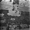
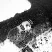
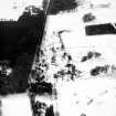
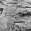
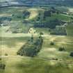
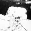
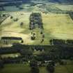
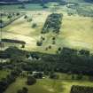
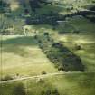
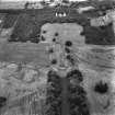
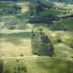
The house stands now in the middle of a commercial forestry plantation, though traces of its once magnificant gardens remain. These were laid out before the present house was built, and can be seen on Roy's map of 1746 which shows, slightly south of the present building, the site of an earlier house which was described, circa 1710 as a "good substantious old house, much repaired and well finished of late; very well planted with a noble avenue from the house to the church". To the south east of the house terraces and flights of stairs lead down to an ornamental canal in front of which stands a small columned ogee-canopied well. In addition there is an embankment laid out in three concentric terraces and an axial avenue of trees. (M.Dean & M.Miers)
Photographic Survey (November 1960)
Photographic survey by the Scottish National Buildings Record in 1960.
Ground Survey (29 September 2009 - 1 October 2009)
Survey of the gardens at Carmichael House

