
Following the launch of trove.scot in February 2025 we are now planning the retiral of some of our webservices. Canmore will be switched off on 24th June 2025. Information about the closure can be found on the HES website: Retiral of HES web services | Historic Environment Scotland
Longwell


Earthwork (Period Unassigned)
Site Name Longwell
Classification Earthwork (Period Unassigned)
Canmore ID 47350
Site Number NS92NE 16
NGR NS 9589 2976
Datum OSGB36 - NGR
Permalink http://canmore.org.uk/site/47350


- Council South Lanarkshire
- Parish Wiston And Roberton
- Former Region Strathclyde
- Former District Clydesdale
- Former County Lanarkshire
NS92NE 16 9589 2976.
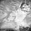
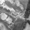
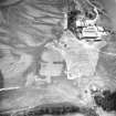
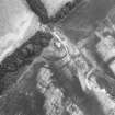
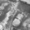
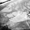
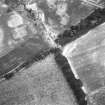
NS 959 297. Earthwork (site of): Air photography by the RCAHMS has revealed the cropmarks of an earthwork 250m NE of Longwell farmhouse, in the angle formed by the junction of the gully of the Dingle Burn with the scarp that borders the haugh of the River Clyde. Two narrow ditches, about 20m apart, have been drawn in an arc from the right bank of the burn to the lip of the scarp, enclosing an area which measures approximately 45m E-W by a maximum of 60m transversely. The ruined cottage of Dingleburn stands within the interior.
RCAHMS 1978, visited 1976
Centred NS 9589 2976. There is no surface evidence of this cropmark in the intensively cultivated arable field.
Visited by OS (MJF) 1 February 1979
NS92NE 15, NS 9590 2973, NS92NE 13 A watching brief took place during the erection of new overhead power lines between Symington and Abington, where the sites for new poles were seen to lie in the immediate vicinity of three unscheduled cropmarks (NMRS NS92NE 13, NS92NE 15, NS92NE 16 ). Work took place between May 1995 and April 1996; no significant archaeological remains were encountered. The cropmark sites themselves were unaffected by the work.
Sponsor: Scottish Power.
H James 1996

