|
Photographs and Off-line Digital Images |
CL 833 PO |
Copies of records from Kincardine Local History Group, Kincardine-on-Forth, Scotland |
Alloa harbour, Copy of historic photograph showing view of sailing boat moored in harbour. |
1910 |
Item Level |
|
|
Photographs and Off-line Digital Images |
CL 834 PO |
Copies of records from Kincardine Local History Group, Kincardine-on-Forth, Scotland |
Alloa harbour, View of boat moored in harbour. |
1910 |
Item Level |
|
|
Photographs and Off-line Digital Images |
A 75849 |
Copies of records from Kincardine Local History Group, Kincardine-on-Forth, Scotland |
Alloa Docks, Copy of historic photograph showing general view. |
1900 |
Item Level |
|
|
Photographs and Off-line Digital Images |
B 31876 PO |
|
General view. |
|
Item Level |
|
|
Manuscripts |
MS 725/138 |
Historic Scotland Archive Project |
Report of coastal assessment survey for Historic Scotland: The Firth of Forth from Dunbar to the border of Fife. (3 volumes)
Revised version with amended text. |
1996 |
Item Level |
|
|
Manuscripts |
MS 2221/05 |
Historic Scotland Archive Project |
Survey archive: List of Vertical Aerial Photographs consulted in the NMRS, from Coastal Assessment Survey, 'The Firth of Forth from Dunbar to the Coast of Fife'. |
1996 |
Item Level |
|
|
Photographs and Off-line Digital Images |
B 78128 |
Copies of records from Kincardine Local History Group, Kincardine-on-Forth, Scotland |
Alloa harbour, General view. |
1900 |
Item Level |
|
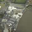 |
On-line Digital Images |
DP 017111 |
RCAHMS Aerial Photography Digital |
Oblique aerial view. Alloa Glass Works, gasholder and harbour from W. |
6/9/2006 |
Item Level |
|
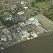 |
On-line Digital Images |
DP 017112 |
RCAHMS Aerial Photography Digital |
Oblique aerial view. Alloa Glass Works, gasholder and harbour from SW. |
6/9/2006 |
Item Level |
|
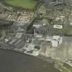 |
On-line Digital Images |
DP 017113 |
RCAHMS Aerial Photography Digital |
Oblique aerial view. Alloa Glass Works, gasholder and harbour from S. |
6/9/2006 |
Item Level |
|
 |
On-line Digital Images |
SC 2432977 |
Records of the Ordnance Survey, Southampton, Hampshire, England |
Alloa Harbour, NS89SE 54, Ordnance Survey index card, Recto |
c. 1958 |
Item Level |
|
 |
On-line Digital Images |
SC 2432978 |
Records of the Ordnance Survey, Southampton, Hampshire, England |
Alloa Harbour, NS89SE 54, Ordnance Survey index card, Recto |
c. 1958 |
Item Level |
|
|
Manuscripts |
MS 2221/01 |
Historic Scotland Archive Project |
Survey archive: Photographic register from Coastal Assessment Survey, 'The Firth of Forth from Dunbar to the Coast of Fife'. |
1996 |
Batch Level |
|
|
Photographs and Off-line Digital Images |
BP 55/10 CN |
Historic Scotland Archive Project |
Survey photographs: South Alloa including Inch farm, bridge and piers; Throsk piers; Fallin; Stirling with Old Bridge and sites of battles and Cambuskenneth Abbey and pier: Manor Neuk; Alloa including gasworks and glassworks with piers at Alloa and Cambus and view of Alloa Harbour. General views of Stirling and Alloa from the river. |
1996 |
Batch Level |
|
|
Photographs and Off-line Digital Images |
BS 47/11 CS |
Historic Scotland Archive Project |
Survey photographs: Alloa showing glassworks and harbour, Clackmannan Pow harbour, Kennetpans cottages harbour and distillery with location of enclosure, Blackness Castle with detail of 'Celtic' figure and site of St Ninian's chapel, pump and harbour at Blackness village, South Queensferry views of streets and houses. View of designed landscape at Kennetpans.
|
1996 |
Batch Level |
|
|
Manuscripts |
MS 2221/02 |
Historic Scotland Archive Project |
Survey archive: Record sheets from Coastal Assessment Survey, 'The Firth of Forth from Dunbar to the Coast of Fife'. |
1996 |
Batch Level |
|
|
Manuscripts |
MS 2221/03 |
Historic Scotland Archive Project |
Survey archive: Record sheets and maps of Erosion Units, from Coastal Assessment Survey, 'The Firth of Forth from Dunbar to the Coast of Fife'. |
1996 |
Batch Level |
|
|
Manuscripts |
MS 2221/04 |
Historic Scotland Archive Project |
Survey archive: Record sheets and maps of Geology and Coastal Geomorphology Units , from Coastal Assessment Survey, 'The Firth of Forth from Dunbar to the Coast of Fife'. |
1996 |
Batch Level |
|


