|
Photographs and Off-line Digital Images |
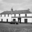
CL 937 |
List C Survey |
General view. |
1975 |
Item Level |
|
|
Manuscripts |
MS 725/138 |
Historic Scotland Archive Project |
Report of coastal assessment survey for Historic Scotland: The Firth of Forth from Dunbar to the border of Fife. (3 volumes)
Revised version with amended text. |
1996 |
Item Level |
|
|
Manuscripts |
MS 2221/05 |
Historic Scotland Archive Project |
Survey archive: List of Vertical Aerial Photographs consulted in the NMRS, from Coastal Assessment Survey, 'The Firth of Forth from Dunbar to the Coast of Fife'. |
1996 |
Item Level |
|
 |
On-line Digital Images |
SC 1629042 |
List C Survey |
General view. |
1975 |
Item Level |
|
 |
On-line Digital Images |
SC 2432954 |
Records of the Ordnance Survey, Southampton, Hampshire, England |
Alloa, The Shore, Mar Inn, NS89SE 37, Ordnance Survey index card, Recto |
c. 1958 |
Item Level |
|
|
Manuscripts |
MS 2221/01 |
Historic Scotland Archive Project |
Survey archive: Photographic register from Coastal Assessment Survey, 'The Firth of Forth from Dunbar to the Coast of Fife'. |
1996 |
Batch Level |
|
|
Manuscripts |
MS 2221/02 |
Historic Scotland Archive Project |
Survey archive: Record sheets from Coastal Assessment Survey, 'The Firth of Forth from Dunbar to the Coast of Fife'. |
1996 |
Batch Level |
|
|
Manuscripts |
MS 2221/03 |
Historic Scotland Archive Project |
Survey archive: Record sheets and maps of Erosion Units, from Coastal Assessment Survey, 'The Firth of Forth from Dunbar to the Coast of Fife'. |
1996 |
Batch Level |
|
|
Manuscripts |
MS 2221/04 |
Historic Scotland Archive Project |
Survey archive: Record sheets and maps of Geology and Coastal Geomorphology Units , from Coastal Assessment Survey, 'The Firth of Forth from Dunbar to the Coast of Fife'. |
1996 |
Batch Level |
|


