
Dumyat


Byre Dwelling(S) (Post Medieval), Farmstead (Post Medieval)(Possible), Hut (Post Medieval)
Site Name Dumyat
Classification Byre Dwelling(S) (Post Medieval), Farmstead (Post Medieval)(Possible), Hut (Post Medieval)
Canmore ID 47155
Site Number NS89NW 49
NGR NS 8295 9843
Datum OSGB36 - NGR
Permalink http://canmore.org.uk/site/47155


- Council Stirling
- Parish Logie (Stirling)
- Former Region Central
- Former District Stirling
- Former County Stirlingshire
Field Visit (28 September 1956)
Old Cottages, Dumyat.
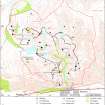
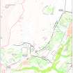
These remains are situated on the N flank of Dumyat, at a height of about 900 ft OD and at a distance of about one-third of a mile S of Lossburn Reservoir. They consist of five rectangular foundations, measuring from 22 ft to 30 ft in length by from 11 ft to 15 ft in width within low, grass-grown, stony mounds. Four lie in a group and one stands by itself 120 yards NW of the others. A spring issues from the hillside at a point about equidistant between the group and the single foundation. The foundations forming the group are disposed about a comparatively level area of the hillside which measures some 120 ft both from SW to NE and transversely; adjoining this on the NW is a rounded enclosure defined by a ruinous stone wall and measuring about 50 ft in diameter. The isolated foundation, which lies on the shelf facing NW, is associated with a small enclosure measuring 12 ft by 9 ft within a ruined and grass-grown stone wall. The foundations and enclosures are probably the remains of a small farmstead, possibly of the 17th or 18th century.
RCAHMS 1956, visited 28 September 1956.
Field Visit (21 May 1997)
NS89NW 49 8295 9843
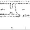
What may be a farmstead, comprising a single byre-house (MENS97 35), two huts (MENS97 36, 39), four buildings (MENS97 25, 37-8, 105) and a patch of unenclosed rig, is situated on a gently sloping terrace on the NW flank of Dumyat. The structures are all aligned across the contour with one exception (MENS97 37) which lies along the contour.
The farmstead or byre-house has two compartments with extensions to both ends (MENS97 35). It measures 13.3m from N to S by 3.5m transversely within turf walls spread to 1m in thickness and 0.3m in height, and there is an entrance in the E of the N compartment. The N, or lower compartment was a byre, with a gap in the middle of the end-wall for the run-off of slurry, and there is a step-up in the floor about 1m short of the partition, which divides the byre from the upper, or domestic end of the building. With the addition of an extension to the N, measuring 3m in length but narrowing to 2.5m in breadth, a new drain was cut in the NE corner of the building emptying into a sump on the outside. Although there is no clearly defined entrance to the extension, it must have lain on the E, there being no possibility of an entrance in the N or W because of the drop in the external ground level. The extension on the S which measures 2.5m in length, appears to have been open to the interior of the main structure, the original end-wall having been slighted to gain access to the extension, which is stepped-up from the interior. Like the rest of the building it is largely turf-walled, but at its SE corner there is a large orthostatic boulder. An expanse of rig runs downslope to the E of the steading.
The huts are subrectangular on plan and measure no more than 3.7m by 3m internally. The S hut (MENS97 36) overlies the end of a building which extends for some 6.4m to the N and measures 2.6m across internally. The dimensions of the buildings vary considerably, from 6.1m by 2.9m internally (MENS97 38) to 13.3m overall by 3.5m (MENS97 35). One building features an outshot measuring 4.6m by 2.9m (MENS97 37).
(MENS97 35-9, 105)
Visited by RCAHMS (DCC and PJD) 25 April and 21 May 1997

