 |
On-line Digital Images |
SC 1325580 |
Records of the Royal Commission on the Ancient and Historical Monuments of Scotland (RCAHMS), Edinbu |
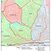
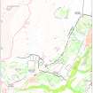
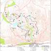
Map showing property names in Menstrie Glen. Fig 9 in "Well shelterd & watered" Menstrie Glen, a farming landscape near Stirling. |
2001 |
Item Level |
|
 |
On-line Digital Images |
SC 1346654 |
Records of the Royal Commission on the Ancient and Historical Monuments of Scotland (RCAHMS), Edinbu |
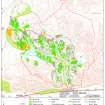
Map showing distribution of settlements in Menstrie Glen before the 1760s with head-dykes and cultivated ground. Fig 11 in "Well shelterd & watered" Menstrie Glen, a farming landscape near Stirling. |
2001 |
Item Level |
|
 |
On-line Digital Images |
SC 1346655 |
Records of the Royal Commission on the Ancient and Historical Monuments of Scotland (RCAHMS), Edinbu |
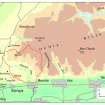
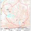
Map of the western end of the Ochils showing the location of Menstrie Glen. Fig 12 in "Well shelterd & watered" Menstrie Glen, a farming landscape near Stirling. |
2001 |
Item Level |
|
 |
On-line Digital Images |
SC 1346656 |
Records of the Royal Commission on the Ancient and Historical Monuments of Scotland (RCAHMS), Edinbu |
Map depicting arable land and settlement in the early 19th century. Fig 21 in "Well shelterd & watered" Menstrie Glen, a farming landscape near Stirling. |
2001 |
Item Level |
|
 |
On-line Digital Images |
SC 1346666 |
Records of the Royal Commission on the Ancient and Historical Monuments of Scotland (RCAHMS), Edinbu |
Illustration showing layout of farmsteads in the Menstrie Glen. Fig 31 in "Well shelterd & watered" Menstrie Glen, a farming landscape near Stirling. |
|
Item Level |
|
 |
On-line Digital Images |
SC 1346671 |
Records of the Royal Commission on the Ancient and Historical Monuments of Scotland (RCAHMS), Edinbu |
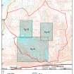
Map of Menstrie Glen showing locations of more detailed maps. Fig 39 in "Well shelterd & watered" Menstrie Glen, a farming landscape near Stirling. |
|
Item Level |
|
 |
On-line Digital Images |
SC 1346672 |
Records of the Royal Commission on the Ancient and Historical Monuments of Scotland (RCAHMS), Edinbu |
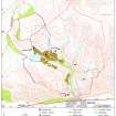
Map of Lipney farm. Fig 41 in "Well shelterd & watered" Menstrie Glen, a farming landscape near Stirling. |
|
Item Level |
|
 |
On-line Digital Images |
SC 1346675 |
Records of the Royal Commission on the Ancient and Historical Monuments of Scotland (RCAHMS), Edinbu |
Map showing the extents of different types of rig in Menstrie Glen. Fig 48 in "Well shelterd & watered" Menstrie Glen, a farming landscape near Stirling. |
|
Item Level |
|
 |
On-line Digital Images |
SC 1346676 |
Records of the Royal Commission on the Ancient and Historical Monuments of Scotland (RCAHMS), Edinbu |
Map showing mine and trial sites in Menstrie Glen. Fig 54 in "Well shelterd & watered" Menstrie Glen, a farming landscape near Stirling. |
|
Item Level |
|
 |
On-line Digital Images |
SC 1346677 |
Records of the Royal Commission on the Ancient and Historical Monuments of Scotland (RCAHMS), Edinbu |
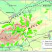
Extent of relict cultivation in the Ochil Hills. Fig 57 in "Well shelterd & watered" Menstrie Glen, a farming landscape near Stirling. |
|
Item Level |
|
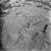 |
On-line Digital Images |
SC 1727327 |
RCAHMS Aerial Photography |
Oblique aerial view. |
1981 |
Item Level |
|
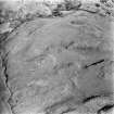 |
On-line Digital Images |
SC 1727328 |
RCAHMS Aerial Photography |
Oblique aerial view. |
1981 |
Item Level |
|
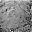 |
On-line Digital Images |
SC 1727329 |
RCAHMS Aerial Photography |
Oblique aerial view. |
1981 |
Item Level |
|
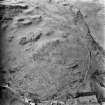 |
On-line Digital Images |
SC 1727330 |
RCAHMS Aerial Photography |
Oblique aerial view. |
1981 |
Item Level |
|
 |
On-line Digital Images |
SC 1727331 |
RCAHMS Aerial Photography |
Oblique aerial view. |
1981 |
Item Level |
|
 |
On-line Digital Images |
SC 1727332 |
RCAHMS Aerial Photography |
Oblique aerial view. |
1981 |
Item Level |
|
 |
On-line Digital Images |
SC 2185384 |
Records of the Royal Commission on the Ancient and Historical Monuments of Scotland (RCAHMS), Edinbu |
Map showing distribution of settlements in Menstrie Glen before the 1760s. Fig 23 in "Well shelterd & watered" Menstrie Glen, a farming landscape near Stirling.showing property names in Menstrie Glen. Fig 12 in "Well shelterd & watered" Menstrie Glen, a farming landscape near Stirling. |
2001 |
Item Level |
|
 |
On-line Digital Images |
SC 2432860 |
Records of the Ordnance Survey, Southampton, Hampshire, England |
Lipney, NS89NW 41, Ordnance Survey index card, Recto |
c. 1958 |
Item Level |
|


