
Myreton Hill


Building (Post Medieval), Clearance Cairn(S) (Period Unknown), Dun (Iron Age) - (Early Medieval), Hut (Period Unknown), Pen (Period Unknown)
Site Name Myreton Hill
Classification Building (Post Medieval), Clearance Cairn(S) (Period Unknown), Dun (Iron Age) - (Early Medieval), Hut (Period Unknown), Pen (Period Unknown)
Canmore ID 47097
Site Number NS89NE 49
NGR NS 8530 9780
Datum OSGB36 - NGR
Permalink http://canmore.org.uk/site/47097


- Council Clackmannan
- Parish Alva
- Former Region Central
- Former District Clackmannan
- Former County Clackmannanshire
Field Visit (1970)
NS89NE 49 8530 9780
NS 853 978 Traces of a circular enclosure 12m in diameter are on the summit of a considerable prominence W of Myreton Hill. Adjoining to the N there is a structure at a slightly lower level which appears to be a platform, terminated at 15m by traces of rubble and suggestions of an entrance.
T C Welsh 1970
Field Visit (19 June 1997)
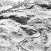
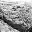
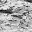
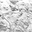
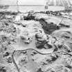
This dun is situated on a rocky boss above the E side of Menstrie Glen, overlooked by Myreton Hill to the E. The ground falls away steeply to E and W, and there are vertical crags to the S; leaving the only easy access from the N, where a ridge descends from the summit in a series of grassy terraces. The visible remains comprise a circular enclosure on the summit of the knoll, with an outer enclosure on the first terrace below it on the NNW. A later hut or pen stands within the outwork and there is another pen, two clearance heaps and a building beyond it to the N.
The dun itself measures 10.5m in diameter within a wall reduced to a grassed-over stony bank about 2m thick. A dip in the bank on the SE may indicate the position of the entrance. The line of the outer face is continued across this possible entrance by two earthfast stones, which may be the remains of a sill; otherwise there are no visible in situ facing stones, although three large stones, probably displaced outer facing stones, lie beyond the wall to the N and stone-robbing is apparent around the inner face from NW to NE. To the NNW of the dun an outwork encloses a terrace which measures about 20m NNW-SSE by 17m transversely. The enclosing wall is reduced to little more than a grass-covered band of stones 1.5m in thickness, thickening to about 2m on either side of the entrance, which lies at the centre of the NNW end. At its SW corner the outwork joins the dun wall but on the SE it terminates at an outcrop above which a ledge around the outer face of the dun may have afforded access to the SE entrance.
There is a subrectangular hut or pen built into the NW corner of the outwork, and there is smaller pen on the terrace below it to the N; two spreads of stone on the edge of this terrace are probably clearance heaps. The building is built against the face of the lower terrace. It measures 15m in length by 5m in breadth at its ESE end, narrowing towards the WNW, within a wall reduced to a stony bank except on the SSW side, where a revetment stands up to two courses high against the face of the terrace. There are two compartments, with an entrance into the E compartment on the NNE side.
Visited by RCAHMS (SDB) 19 June 1997
Field Visit (10 May 2022)
The classification, location and period of this site record have been reviewed as part of record revision work carried out by HES Designations.
Visited by HES Designations (F I O'Shea), 10/05/2022.

