|
Photographs and Off-line Digital Images |
SC 2006014 |
Cambridge University Collection for Aerial Photography |
Aerial view |
22/7/1962 |
Item Level |
|
|
Photographs and Off-line Digital Images |
SC 2006015 |
Cambridge University Collection for Aerial Photography |
Aerial view |
27/7/1963 |
Item Level |
|
|
Photographs and Off-line Digital Images |
D 92112 PO |
Cambridge University Collection for Aerial Photography |
Aerial photograph. |
27/7/1968 |
Item Level |
|
|
Photographs and Off-line Digital Images |
D 92113 PO |
Cambridge University Collection for Aerial Photography |
Aerial photograph. |
1/8/1969 |
Item Level |
|
|
Photographs and Off-line Digital Images |
SC 2006252 |
Cambridge University Collection for Aerial Photography |
Aerial photograph. |
27/7/1968 |
Item Level |
|
|
Photographs and Off-line Digital Images |
SC 2006253 |
Cambridge University Collection for Aerial Photography |
Aerial photograph. |
1/8/1969 |
Item Level |
|
|
Photographs and Off-line Digital Images |
D 92114 PO |
Cambridge University Collection for Aerial Photography |
Aerial photograph. |
31/7/1975 |
Item Level |
|
|
Photographs and Off-line Digital Images |
D 92115 PO |
Cambridge University Collection for Aerial Photography |
Aerial photograph. |
22/7/1976 |
Item Level |
|
|
Photographs and Off-line Digital Images |
SC 2007054 |
Cambridge University Collection for Aerial Photography |
Aerial photograph. |
31/7/1975 |
Item Level |
|
|
Photographs and Off-line Digital Images |
SC 2007055 |
Cambridge University Collection for Aerial Photography |
Aerial photograph. |
22/7/1976 |
Item Level |
|
|
Digital Files (Non-image) |
GV 008531 |
Records of Historic Scotland, Edinburgh, Scotland |
Map showing the Antonine Wall, the World Heritage Site area, the areas of the World Heritage Site in public ownership or care, the Buffer Zone and the Council boundaries. Created for the World Heritage Site nomination - Management plan. |
2006 |
Item Level |
|
 |
On-line Digital Images |
SC 2170806 |
Records of Historic Scotland, Edinburgh, Scotland |
Map showing the Antonine Wall, the World Heritage Site area, the areas of the World Heritage Site in public ownership or care, the Buffer Zone and the Council boundaries. Created for the World Heritage Site nomination - Management plan. |
2006 |
Item Level |
|
|
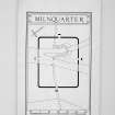
Photographs and Off-line Digital Images |
DP 385885 |
|
Publication drawing; map of Milnquarter Roman temporary camp superimposed upon the OS map (sheet nxxxix.8) (Feachem 1958 fig. 2) |
1958 |
Item Level |
|
 |
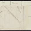
On-line Digital Images |
DP 385887 |
|
Plan, ink, 1":100' |
1958 |
Item Level |
|
|
Photographs and Off-line Digital Images |
AT 003547 |
Historic Environment Scotland |
Imagery and Mapping Files for Aerial Photo Transcription. |
27/6/2022 |
Item Level |
|
|
Photographs and Off-line Digital Images |
AT 003549 |
Historic Environment Scotland |
Imagery and Mapping Files for Aerial Photo Transcription. |
27/6/2022 |
Item Level |
|
|
Photographs and Off-line Digital Images |
AT 003550 |
Historic Environment Scotland |
Imagery and Mapping Files for Aerial Photo Transcription. |
27/6/2022 |
Item Level |
|
|
Photographs and Off-line Digital Images |
AT 003551 |
Historic Environment Scotland |
Imagery and Mapping Files for Aerial Photo Transcription. |
27/6/2022 |
Item Level |
|
|
Photographs and Off-line Digital Images |
AT 003548 |
Historic Environment Scotland |
Imagery and Mapping Files for Aerial Photo Transcription. |
27/6/2022 |
Item Level |
|
 |
On-line Digital Images |
SC 2432119 |
Records of the Ordnance Survey, Southampton, Hampshire, England |
Milnquarter, NS87NW 5, Ordnance Survey index card, Recto |
c. 1958 |
Item Level |
|
 |
On-line Digital Images |
SC 2432120 |
Records of the Ordnance Survey, Southampton, Hampshire, England |
Milnquarter, NS87NW 5, Ordnance Survey index card, Recto |
c. 1958 |
Item Level |
|
 |
On-line Digital Images |
SC 2432121 |
Records of the Ordnance Survey, Southampton, Hampshire, England |
Milnquarter, NS87NW 5, Ordnance Survey index card, Recto |
c. 1958 |
Item Level |
|
 |
On-line Digital Images |
SC 2432122 |
Records of the Ordnance Survey, Southampton, Hampshire, England |
Milnquarter, NS87NW 5, Ordnance Survey index card, Recto |
c. 1958 |
Item Level |
|
|
Photographs and Off-line Digital Images |
D 92110 PO |
Cambridge University Collection for Aerial Photography |
Oblique aerial view of Milnquarter: Roman temporary camp; linear cropmarks. |
1/8/1965 |
Item Level |
|


