
Pricing Change
New pricing for orders of material from this site will come into place shortly. Charges for supply of digital images, digitisation on demand, prints and licensing will be altered.
Antonine Wall; Tentfield East And West


Signal Platform(S) (Roman)
Site Name Antonine Wall; Tentfield East And West
Classification Signal Platform(S) (Roman)
Alternative Name(s) Tentfield Expansions
Canmore ID 46781
Site Number NS87NE 5
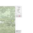
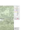
NGR NS 8556 7981
NGR Description NS 8556 7981 and NS 8500 7990
Datum OSGB36 - NGR
Permalink http://canmore.org.uk/site/46781


- Council Falkirk
- Parish Falkirk
- Former Region Central
- Former District Falkirk
- Former County Stirlingshire
NS87NE 5.00 8556 7981 to 8500 7990
NS87NE 5.01 8556 7981
NS87NE 5.02 8500 7990
(NS 8500 7990) Expansion (R)
(NS 8556 7981) Expansion (R)
OS 25" map (1961)
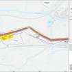
There are two 'expansions' projecting from the S face of the Antonine Wall rampart at Tentfield. They are to be compared with that at Bonnyside East (NS87NW 4) which was proved by excavation by the RCAHMS to have been a rectangular beacon stance, communicating with the area N of the Wall, its semi-circular shape in 1957 being due to the collapse of weathered turfwork.
The expansion at NS 8500 7990 was barely discernible in 1957, but would seem to be identical with that noted by Roy and represented by him as a small square earthwork, 18' each way, abutting on the S face of the wall.
The other expansion at NS 8556 7981, was roughly semicircular, about 32' E-W at the rampart face by 18' N-S and 3' in height, mutilated on top by a large hole where a tree had been uprooted.
W Roy 1793; K A Steer 1959; RCAHMS 1963, visited 1957.
The badly mutilated remains of the expansion at NS 8500 7990 may still be seen in the form of a roughly semicircular mound, about 8.0m E-W, protruding 7.0m from the rampart, and 1.3m high.
The expansion at NS 8556 7990 is as described.
Surveyed at 1:2500.
Visited by OS (JLD) 29 January 1957
No change to previous field report.
Visited by OS (JRL) 20 April 1980.
Field Visit (July 1977)
Tentfield East and West, NS 855 798 NS87NE 5
Listed as a signalling platforms.
RCAHMS 1978, visited July 1977
(Macdonald 1934, 128, 351-3; Steer 1957; RCAHMS 1963, pp. 93-6, No. 111; Robertson 1973, 55)
Publication Account (2008)
A 1:25000 scale map of the Antonine Wall was published by RCAHMS in 2008. The map shows the course of the Antonine Wall on a modern map base, including areas where the Wall is in public ownership or care and can be visited. The data had been collated as part of the project to prepare maps for the World Heritage Site nomination bid.

