
Pricing Change
New pricing for orders of material from this site will come into place shortly. Charges for supply of digital images, digitisation on demand, prints and licensing will be altered.
Bedlormie House


Lairds House (17th Century), Tower House (Medieval)
Site Name Bedlormie House
Classification Lairds House (17th Century), Tower House (Medieval)
Alternative Name(s) Bedlormie Mains; Old Bedlormie
Canmore ID 46716
Site Number NS86NE 3
NGR NS 87470 67334
Datum OSGB36 - NGR
Permalink http://canmore.org.uk/site/46716


- Council West Lothian
- Parish Torphichen
- Former Region Lothian
- Former District West Lothian
- Former County West Lothian
Bedlormie Mains, 17th century
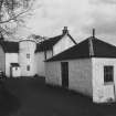
Long, white, L-plan house, decapitated stair-tower in the angle: faint echo of Old Bedlormie acquired by Sir Alexander Livingston of Ogilface, shrunk by at least a storey, the ground floor opened out like a later farmhouse, under a shallow 19th-century roof.
Taken from "West Lothian: An Illustrated Architectural Guide", by Stuart Eydmann, Richard Jaques and Charles McKean, 2008. Published by the Rutland Press http://www.rias.org.uk

NS86NE 3 8747 6733.
(NS 9747 6733) Bedlormie (NR)
OS 6"map, (1967).
Bedlormie House: Originally the fortalice of Bedlormie estate was a plain peel-type tower, square and vaulted; the present building is a fairly typical L-shaped laird's house of the early 17th c, now lowered in height by a storey and considerably altered. The main block lies E-W, with the wing projecting N, and in the re-entrant angle rises a circular stair-tower with a conical roof. The only external features remaining are the roll-mouldings of the ground floor windows.
N Tranter 1970; RCAHMS 1929, visited 1924.
It is whitewashed, and in use as a farmhouse.
Visited by OS(JFC) 8 March 1955.
The conical roof of the stair-tower was demolished during a storm in 1968. Otherwise, Bedlormie is as described above.
Visited by OS(BS) 8 August 1974.
Field Visit (25 February 1924)
Bedlormie.
At the western extremity of the county and four miles west-south-west of Armadale, the farm-house of Bedlormie stands on rising ground north of the road from Airdrie to Armadale. It is a small harled house built on an L-plan and dating from the 17th century, but has been reduced in height to two storeys and considerably altered; the re-entrant angle opens to the north-west and contains the newel stair within a circular tower. The lower windows of the house have a roll-and-quirk moulding on jambs and lintel, while the upper windows have margins back-set and chamfered. Neither storey is vaulted, and internally the structure has been modernised. The parlour, which faces south, contains a small 18th-century panel in plaster, comprising figures, scroll-work, and a cartouche. The structure is in fair condition.
HISTORICAL NOTE. In 1424 John de ‘Murrefe’ (Murray) of Ogilface (RCAHMS 1929, No. 394) granted the whole lands of Bedlormie to Sir John ‘Forstare’ (Forrester), Master of the King's Household. In 1645 George, Lord Forrester of Corstorphine, was superior of Bedlormie, and the lands were held from him by Patrick Walker (Laing Charters, Nos. 101, 2361).
RCAHMS 1929, visited 25 February 1924.
OS 6-inch map: viii S.W.

