
Calda House


House (Medieval)
Site Name Calda House
Classification House (Medieval)
Alternative Name(s) Eddrachalder House; Eddercalder House; The White House
Canmore ID 4661
Site Number NC22SW 3
NGR NC 24385 23347
Datum OSGB36 - NGR
Permalink http://canmore.org.uk/site/4661


- Council Highland
- Parish Assynt
- Former Region Highland
- Former District Sutherland
- Former County Sutherland
NC22SW 3 24385 23347.
(NC 2436 2334) Calda House (NR) (remains of)
OS 6" map, (1967)
Named 'Calda House'
J Home 1774-5.
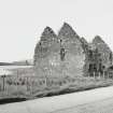
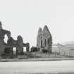
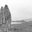
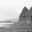
Edderchalder, Calder of Calda House, known locally as the White House, is said to have been erected in 1660 by the 3rd Earl of Seaforth. It was an oblong block of two storeys and an attic, divided in two by a wall running down the centre, but it is now roofless and much ruined with the side facing the loch having disappeared entirely. It is said to have been reduced to this state deliberately by fire in the mid-18th century.
NSA 1845; D MacGibbon and T Ross 1889; RCAHMS 1911.
Calda House, which is no more than a shell, measures overall 16.5 m N-S by 13.5 m; otherwise it is as described above.
Visited by OS (G H P) 23 May 1962 and (J B) 12 August 1980.
Publication Account (1995)
Standing in empty countryside against a backdrop of loch and mountains, Ardvreck Castle and Calda House must be counted amongst the best romantic ruins.
The ruins of Edderchalder or Calda House stand beside the road a short distance south of the castle. Built for the Mackenzies in the 1720s, its domestic style of architecture is in complete contrast to its predecessor. The house was a double block two storeys high with an attic, each half having a pitched roof, and it probably had a centtal staircase. There were chimneys in each of the four gables and another chimney stack, now fallen, in the centre of the house, so some sixteen rooms had fireplaces. It was gutted by fire in 1737. It has been suggested that this commodious house, which has some resemblance to contemporary barracks such as Bernera (no. 43), may have served as a garrison post, if need be, as well as a domestic residence. Beside Loch Assynt and near Elphin are outcrops of limestone rock and the soil is unusually fertile, a fact appreciated by farmers since prehistoric times. Neolithic chambered cairns can be found scattered along the lin e of the A 837 from Loch Assynt south to Loch Borrolan.
Information from ‘Exploring Scotland’s Heritage: The Highlands’, (1995).
Field Visit (9 December 2009)
Situated on the flat land between the road and Loch Assynt are the remains of Calda House. The structure is 17m by 13m and 7m high, and comprises a three storey mortared stone house, aligned N/S. There is a subdivision within the structure running N/S but not the whole way across the building. The W elevation and W end of the E elevation have collapsed. The collapsed E elevation lies on the ground where it collapsed, but the stone from the W elevation is missing. The building survives on both gable ends and was the first M-shaped gable house in NW Scotland. Holes for the roof joists are evident on the internal elevations as are a number of fireplaces. An area of collapse has made the chimney flue visible on the south elevations and there are a number of obvious replaced concrete and wooden lintels throughout.
(HLP_no 142)
Assynt's Hidden Lives 2009

