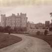
Accessibility

Font Size

100% 150% 200%

Background Colour

Default Contrast
Close Reset

Douglas Castle

Castle (17th Century)

Site Name Douglas Castle

Classification Castle (17th Century)

Canmore ID 46528

Site Number NS83SW 4

NGR NS 84242 31841

Datum OSGB36 - NGR

Permalink http://canmore.org.uk/site/46528

Ordnance Survey licence number AC0000807262. All rights reserved.
Canmore Disclaimer. © Bluesky International Limited 2025. Public Sector Viewing Terms

Toggle Aerial | View on large map

Digital Images

Oblique aerial view centred on the remains of the castle, taken from the SSW.
Oblique aerial view centred on the remains of the castle, taken from the SSW.Group of 15 people, possibly in the grounds of the castle.
Slide insc. 'Castle Dangerous, Douglas 1935'General oblique aerial view of Douglas, military camp and Douglas Castle, looking NE.Aerial View.Aerial View.Oblique aerial view of Douglas Castle, taken from the NNW.General view of castle.
Titled: 'Douglas Castle'
PHOTOGRAPH ALBUM No 11:  Kirsty's Banff AlbumOblique aerial view of Douglas Castle, looking NE.Oblique aerial view of Douglas Castle and former ornamental garden, looking NNW.Oblique aerial view centred on the remains of the castle and gardens , taken from the N.General oblique aerial view of Douglas Castle, taken from the SW.Oblique aerial view of Douglas Castle and former ornamental garden, looking SW.Oblique aerial view of Douglas Castle and former ornamental garden, looking SSW.Oblique aerial view of Douglas Castle and former ornamental garden, looking NNE.Oblique aerial view of Douglas Castle, looking WNW.Oblique aerial view of Douglas Castle, looking W.View of gate-lodge.Aerial View.Aerial View.Douglas Castle, NS83SW 4, Ordnance Survey index card, RectoOblique aerial view of Douglas Castle, taken from the W.Distant view of stables, Douglas Castles.Oblique aerial view of Douglas Castle, former ornamental garden and Cameronian Scottish Rifles War Memorial, looking NNE.View of Douglas Castle.

View of Douglas Castle from S.Oblique aerial view centred on the remains of the castle and gardens, taken from the SW.Oblique aerial view of Douglas Castle, taken from the S.View of wedding party.
Page 4. PHOTOGRAPH ALBUM No 117:  The Douglas Castle Album.Oblique aerial view of Douglas Castle, looking NNE.Douglas Castle, stronghold of the Douglas FamilyOblique aerial view of Douglas castle and military camp, looking SE.Oblique aerial view of Douglas Castle and former ornamental garden, looking SSW.Oblique aerial view of Douglas Castle, looking N.Aerial view.Oblique aerial view centred on the remains of the castle and gardens, taken from the WSW.General oblique aerial view of Douglas Castle, taken from the SSE.View of gate, possibly at Douglas Castle. 
Titled: 'Gate in garden'. 
PHOTOGRAPH ALBUM No 11: Kirsty's Banff AlbumOblique aerial view of Douglas Castle and former ornamental garden, looking ENE.Oblique aerial view of Douglas Castle, former ornamental garden and Cameronian Scottish Rifles War Memorial, looking NE.Oblique aerial view.Douglas Castle, NS83SW 4, Ordnance Survey index card, RectoOblique aerial view centred on the remains of the castle and gardens, taken from the NNW.Oblique aerial view of Douglas Castle, taken from the S.Oblique aerial view of Douglas Castle, taken from the SE.West, East and side Elevations of Douglas Castle.
Taken from W Adam, Vitruvius Scoticus, 1812, Plate 136
Oblique aerial view of Douglas Castle and former ornamental garden, looking ESE.Oblique aerial view of Douglas Castle, former ornamental garden and Cameronian Scottish Rifles War Memorial, looking ESE.Aerial View.Oblique aerial view.Douglas Castle, NS83SW 4, Ordnance Survey index card, page number 1, RectoDouglas Castle, NS83SW 4, Ordnance Survey index card, page number 2, Verso

Administrative Areas

  • Council South Lanarkshire
  • Parish Douglas
  • Former Region Strathclyde
  • Former District Clydesdale
  • Former County Lanarkshire

Archaeology Notes

NS83SW 4.00 84242 31841.

(NS 8424 3183) Castle (NR) (Ruins)

OS 6" map, Lanarkshire, 2nd ed., (1912).

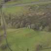
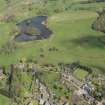
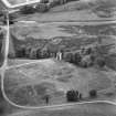
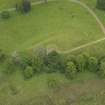
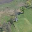
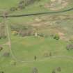
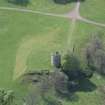
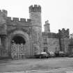
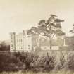
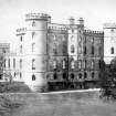
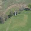
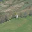
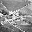
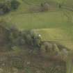
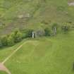
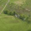
Douglas Castle: The solitary tower which represents the old castle is not earlier than the 17th century and seems to have been a detached building connected with the enclosing walls.

The earliest notice of Douglas Castle occurs in 1288. In 1755 the whole structure, with the exception of the circular tower was destroyed by fire.

D MacGibbon and T Ross 1892.

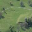
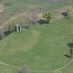
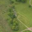
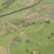
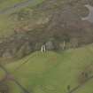
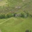
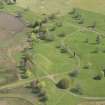
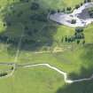
Remains of a round tower 7.0m in diameter with walls 1.0m thick and standing to a height of some 9.0m.

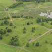
It appears to have been joined to a larger edifice in the SE where there is a break. The tower is in good condition and seems to have been restored at some time. Standing on a prominent spur, it is detached from the adjacent, now ruinous modern mansion.

Visited by OS(JLD) 4 August 1954.

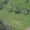
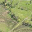
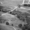
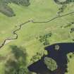
Photographed by RCAHMS in 1980

RCAHMS AP Catalogue 1980.

Architecture Notes

NS83SW 4.00 84242 31841

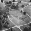
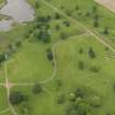
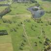
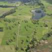
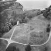
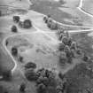
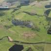
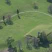
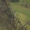
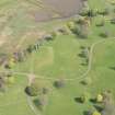
NS83SW 4.01 centred NS 84150 32306 Formal Garden; Sundial; Fountain

For Gardeners cottage see NS83SW 13

NMRS REFERENCE:

Demolished. Unroofed c. 1939.

Douglas Castle and Chapel which were Category B Listed have been demolished.

Information from Demolitions catalogue held in RCAHMS library.

Architect: George Henderson - chapel 1888

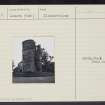
McGibbon and Ross - sundial

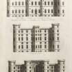
Adam Office 1757 - addition

James Playfair - designs for addition 1791 - not executed

James Gillespie Graham - design for addition 1826

William Burn - entrance gate and lodge

Henry Wilson - design for reredos and altar rail in chapel

Wardrop and Reid designs for Chapel and Hall 188( )

Owen Jones - schemes for decoration

EXTERNAL REFERENCE:

Public Libraries. Scotsman, October 16th, 1937.

Public Libraries. SMT Magazine, December 1935.

Activities

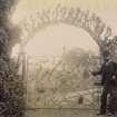
Photographic Record (1865 - 1867)

Photograph album with photos compiled and photographed by J McGhie, Hamilton.

Photographic Survey (1956)

Photographic survey by the Scottish National Buildings Record in 1956.

References

MyCanmore Image Contributions


Contribute an Image

MyCanmore Text Contributions