
Following the launch of trove.scot in February 2025 we are now planning the retiral of some of our webservices. Canmore will be switched off on 24th June 2025. Information about the closure can be found on the HES website: Retiral of HES web services | Historic Environment Scotland
Mount Stewart


Enclosure (Period Unassigned)
Site Name Mount Stewart
Classification Enclosure (Period Unassigned)
Canmore ID 46513
Site Number NS83SE 5
NGR NS 88346 33048
Datum OSGB36 - NGR
Permalink http://canmore.org.uk/site/46513


- Council South Lanarkshire
- Parish Douglas
- Former Region Strathclyde
- Former District Clydesdale
- Former County Lanarkshire
NS83SE 5 8834 3304
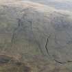
At NS 8834 3304 in a north-west facing hillside is a circular enclosure, measuring 7.0m diameter inside a bank whose main spread 2.0-2.5m broad increases to 3.0m in the sides of an entrance from the north. Internally the enclosure is 0.5 to 0.8m high in the northern half, increasing to 1.2m in the south arc. No stonework is evident in the bank and where erosion of the turf mantle has occurred an earthen infill is revealed. there is no trace of cultivation in the vicinity.
The date and purpose of this feature cannot be ascertained. There are disused quarry workings nearby, and it could be a small quarry scoop.
Visited by OS(JM) 23 March 1978.
Geophysical Survey (February 1990)
Detailed survey of several sites in the area prior to the M74 motorway.

