
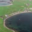
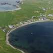
Hillswick


Broch (Iron Age)(Possible), Burial Ground (Post Medieval), Parish Church (16th Century) - (19th Century)
Site Name Hillswick
Classification Broch (Iron Age)(Possible), Burial Ground (Post Medieval), Parish Church (16th Century) - (19th Century)
Canmore ID 465
Site Number HU27NE 13
NGR HU 2811 7700
Datum OSGB36 - NGR
Permalink http://canmore.org.uk/site/465


- Council Shetland Islands
- Parish Northmavine
- Former Region Shetland Islands Area
- Former District Shetland
- Former County Shetland
HU27NE 13 2811 7700
See also HU27NE 21.
(HU 2811 7700) Brough (NR) (Site of)
OS 6" map, Shetland, 2nd ed. (1900)
The site of a broch of which nothing remains because, in the 16th c, the site was fenced around and flattened and a new parish church built on it, the enclosure being used as a burial ground. This church was in use until about 1870, when a new church was built on a different site (HU 2830 7712). The burial ground is still in use and stones from the broch are found in digging graves. Nothing remains of the old church.
The broch appears to have had a moat surrounding it as there is a small loch close by and the enclosed ground is a good deal high than the surrounding ground. (Name Book 1878)
Statistical Account (OSA) 1794 (Rev W Jack)
No trace and no local knowledge of a broch here. Occasional dressed stones from the church, demolished c 1870, have been found during grave-digging. The graveyard is still used.
Visited by OS (NKB) 25 April 1969
Field Visit (5 August 1931)
Indeterminate Site, Hillswick.
A broch is marked on the O.S. map as situated on the low-lying ground which is now enclosed as a graveyard (1). It has not, however, been accepted for the purposes of this Inventory, as it was not included in the list of brochs supplied to Anderson in 1871 by Russell (2), and the long handled weaving combs (now in the National Museum), which were found with remains of roe and red deer in a kitchen-mid den not far off (3), are insufficient as proofs of the former existence of a broch.
RCAHMS 1946, visited 5 August 1931
(1) The three gravestones built into the wall of this graveyard are excluded from the Inventory as their date is later than 1707.
(2) Arch. Scot., v, pp. 179-83.
(3) P.S.A.S., ix (1870-2), pp. 146-7.
OS 6" map, Shetland, 2nd ed. (1900)
Publication Account (1997)
A sheltered bay on the west side of Ura Firth accounts for the location of the village. One of the wings of Hillswick House is the Booth bar, which may have originated in the 18th century as a merchant's store. There are elaborately carved 18th-century tombstones built into the wall on either side of the entrance to the graveyard. Hillswick House itself was built around 1800 with dormer windows added in Victorian times. The present parish church was built in 1869, and the fortunes of the village expanded with a fledgling tourist trade towards the end of the century.
The most remarkable monument to that tourist trade is the St Magnus Hotel. It is remarkable because, in a treeless landscape, it is built of wood.It stands on the slope above the harbour, painted white and black to ensure that it was visible as the cruise passengers sailed into the voe. The materials were imported from Norway by the North of Scotland & Orkney & Shetland Steam Navigation Company, and their capacious hotel was erected in 1900. It has two stories and an attic, and the hall and dining-room retain their fine panelling of stained pine. The guests, who had embarked at Leith, were entertained with guided tours of Shetland with the hotel as their base. These cruises came to an end in 1971, bur the hotel is still a welcoming sight.
Information from ‘Exploring Scotland’s Heritage: Shetland’, (1997).
Publication Account (2002)
HU27 1 HILLSWICK 1 (‘Kirk Loch’)
HU/281770
Site of possible broch in Northmavine; a church, now demolished, was built in the 16th century on the site which was apparently previously flattened [1]. The Commission thought the evidence insufficient to classify the site as a broch [2], though long-handled bone combs, pottery, bone implements, bones and shells were found in a midden not far off [3]; the combs are of Iron Age type [3].
Sources: 1. OS card HU 27 NE 13: 2. RCAHMS 1946, vol. 3, no. 1388, 99: 3. Coughtrey 1872, 146-7.
E W MacKie 2002

