
Pricing Change
New pricing for orders of material from this site will come into place shortly. Charges for supply of digital images, digitisation on demand, prints and licensing will be altered.
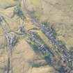
Leadhills, General


Burgh (Medieval), Village (Period Unassigned)
Site Name Leadhills, General
Classification Burgh (Medieval), Village (Period Unassigned)
Alternative Name(s) Hopeton
Canmore ID 46414
Site Number NS81SE 8
NGR NS 8863 1497
Datum OSGB36 - NGR
Permalink http://canmore.org.uk/site/46414
Ordnance Survey licence number AC0000807262. All rights reserved.
Canmore Disclaimer.
© Bluesky International Limited 2025. Public Sector Viewing Terms
- Correction
- Favourite

DP 007604
General oblique aerial view of the village and field system, taken from the NNW.
RCAHMS Aerial Photography Digital
6/3/2006
© Crown Copyright: HES

DP 007623
Oblique aerial view of the village, the railway and the remains of the field banks, taken from the NNW.
RCAHMS Aerial Photography Digital
6/3/2006
© Crown Copyright: HES

DP 007638
Oblique aerial view of the village and the remains of the field banks and lazy beds, taken from the SE.
RCAHMS Aerial Photography Digital
6/3/2006
© Crown Copyright: HES

DP 187807
Oblique aerial view of Leadhills, looking S.
RCAHMS Aerial Photography Digital
29/4/2014
© Crown Copyright: HES

DP 208780
Oblique aerial view of Leadhills village and cultivation remains, looking E.
RCAHMS Aerial Photography Digital
18/11/2014
© Crown Copyright: HES

DP 208792
Oblique aerial view of Leadhills village and cultivation remains, looking NE.
RCAHMS Aerial Photography Digital
18/11/2014
© Crown Copyright: HES

DP 208810
Oblique aerial view of Leadhills village, the mining remains and the field systems, looking W.
RCAHMS Aerial Photography Digital
18/11/2014
© Crown Copyright: HES

DP 208811
Oblique aerial view of Leadhills village, the mining remains and the field systems, looking W.
RCAHMS Aerial Photography Digital
18/11/2014
© Crown Copyright: HES

DP 208830
Oblique aerial view of Leadhills, the mining remains and the field systems, looking W.
RCAHMS Aerial Photography Digital
18/11/2014
© Crown Copyright: HES

DP 209082
Oblique aerial view of the mining and cultivation remains and Leadhills village, looking SW.
RCAHMS Aerial Photography Digital
18/11/2014
© Crown Copyright: HES

DP 209083
Oblique aerial view of the mining and cultivation remains and Leadhills village, looking SSW.
RCAHMS Aerial Photography Digital
18/11/2014
© Crown Copyright: HES


DP 007606
General oblique aerial view of the village and field system, taken from the W.
RCAHMS Aerial Photography Digital
6/3/2006
© Crown Copyright: HES

DP 007607
General oblique aerial view of the village and field system, taken from the SSW.
RCAHMS Aerial Photography Digital
6/3/2006
© Crown Copyright: HES

DP 007640
Oblique aerial view of the village and the remains of the field banks and lazy beds, taken from the E.
RCAHMS Aerial Photography Digital
6/3/2006
© Crown Copyright: HES

DP 187803
Oblique aerial view of Leadhills and Leadhills Golf Course, looking W.
RCAHMS Aerial Photography Digital
29/4/2014
© Crown Copyright: HES

DP 208791
Oblique aerial view of Leadhills village and cultivation remains, looking NE.
RCAHMS Aerial Photography Digital
18/11/2014
© Crown Copyright: HES

DP 208795
Oblique aerial view of the mining and cultivation remains centred on NS 8843 1436, looking N.
RCAHMS Aerial Photography Digital
18/11/2014
© Crown Copyright: HES

DP 208808
Oblique aerial view of the mining remains and field systems, looking W.
RCAHMS Aerial Photography Digital
18/11/2014
© Crown Copyright: HES

DP 208813
Oblique aerial view of Leadhills village, the mining remains and the field systems, looking WSW.
RCAHMS Aerial Photography Digital
18/11/2014
© Crown Copyright: HES

DP 208893
General oblique aerial view of Leadhills village, the mining remains and the golf course, looking E.
RCAHMS Aerial Photography Digital
18/11/2014
© Crown Copyright: HES

DP 208895
General oblique aerial view of Leadhills village, the mining remains and the golf course, looking E.
RCAHMS Aerial Photography Digital
18/11/2014
© Crown Copyright: HES

DP 208897
General oblique aerial view of Leadhills village, the mining remains and the golf course, looking E.
RCAHMS Aerial Photography Digital
18/11/2014
© Crown Copyright: HES


DP 007610
General oblique aerial view of the village and railway, taken from the ENE.
RCAHMS Aerial Photography Digital
6/3/2006
© Crown Copyright: HES

DP 007630
Oblique aerial view of the field banks and lazy beds, taken from the NE.
RCAHMS Aerial Photography Digital
6/3/2006
© Crown Copyright: HES

DP 187797
Oblique aerial view of Leadhills and Leadhills Golf Course, looking N.
RCAHMS Aerial Photography Digital
29/4/2014
© Crown Copyright: HES

DP 208796
Oblique aerial view of Leadhills village and cultivation remains, looking NNW.
RCAHMS Aerial Photography Digital
18/11/2014
© Crown Copyright: HES

DP 208875
Oblique aerial view of Leadhills Golf Course, the mining remains and the field systems, looking SW.
RCAHMS Aerial Photography Digital
18/11/2014
© Crown Copyright: HES

DP 209081
Oblique aerial view of the mining remains and Leadhills village, looking SW.
RCAHMS Aerial Photography Digital
18/11/2014
© Crown Copyright: HES

DP 208812
Oblique aerial view of Leadhills village, the mining remains and the field systems, looking W.
RCAHMS Aerial Photography Digital
18/11/2014
© Crown Copyright: HES

DP 007601
General oblique aerial view of the village and field system, taken from the E.
RCAHMS Aerial Photography Digital
6/3/2006
© Crown Copyright: HES

DP 007608
General oblique aerial view of the village and field system, taken from the S.
RCAHMS Aerial Photography Digital
6/3/2006
© Crown Copyright: HES

DP 007620
Oblique aerial view of the village, the railway and the remains of the field banks, taken from the ENE.
RCAHMS Aerial Photography Digital
6/3/2006
© Crown Copyright: HES

DP 007621
Oblique aerial view of the village, the railway and the remains of the field banks, taken from the NNE.
RCAHMS Aerial Photography Digital
6/3/2006
© Crown Copyright: HES

DP 007622
Oblique aerial view of the village, the railway and the remains of the field banks, taken from the N.
RCAHMS Aerial Photography Digital
6/3/2006
© Crown Copyright: HES

DP 007632
Oblique aerial view of the field banks and lazy beds with the village adjacent, taken from the N.
RCAHMS Aerial Photography Digital
6/3/2006
© Crown Copyright: HES

DP 007637
Oblique aerial view of the village and the remains of the field banks and lazy beds, taken from the S.
RCAHMS Aerial Photography Digital
6/3/2006
© Crown Copyright: HES

DP 187794
Oblique aerial view of Leadhills and Leadhills Golf Course, looking W.
RCAHMS Aerial Photography Digital
29/4/2014
© Crown Copyright: HES

DP 187799
Oblique aerial view of Leadhills and Leadhills Golf Course, looking NW.
RCAHMS Aerial Photography Digital
29/4/2014
© Crown Copyright: HES

DP 187806
Oblique aerial view of Leadhills, looking S.
RCAHMS Aerial Photography Digital
29/4/2014
© Crown Copyright: HES

DP 208782
Oblique aerial view of Leadhills village and cultivation remains, looking E.
RCAHMS Aerial Photography Digital
18/11/2014
© Crown Copyright: HES

DP 208809
Oblique aerial view of Leadhills village, the mining remains and field systems, looking W.
RCAHMS Aerial Photography Digital
18/11/2014
© Crown Copyright: HES

DP 208894
General oblique aerial view of Leadhills village, the mining remains and the golf course, looking E.
RCAHMS Aerial Photography Digital
18/11/2014
© Crown Copyright: HES


DP 007602
General oblique aerial view of the village and field system, taken from the NE.
RCAHMS Aerial Photography Digital
6/3/2006
© Crown Copyright: HES

DP 007624
Oblique aerial view of the village, the railway and the remains of the field banks, taken from the NW.
RCAHMS Aerial Photography Digital
6/3/2006
© Crown Copyright: HES

DP 007633
Oblique aerial view of the field banks and lazy beds with the village adjacent, taken from the NW.
RCAHMS Aerial Photography Digital
6/3/2006
© Crown Copyright: HES

DP 007636
Oblique aerial view of the village and the remains of the field banks and lazy beds, taken from the S.
RCAHMS Aerial Photography Digital
6/3/2006
© Crown Copyright: HES

DP 187801
Oblique aerial view of Leadhills and Leadhills Golf Course, looking W.
RCAHMS Aerial Photography Digital
29/4/2014
© Crown Copyright: HES

DP 208789
Oblique aerial view of Leadhills village and cultivation remains, looking ENE.
RCAHMS Aerial Photography Digital
18/11/2014
© Crown Copyright: HES

DP 208797
Oblique aerial view of Leadhills village and cultivation remains, looking NNW.
RCAHMS Aerial Photography Digital
18/11/2014
© Crown Copyright: HES

DP 208899
General oblique aerial view of Leadhills village and reservoir, and the the mining remains, looking NNE.
RCAHMS Aerial Photography Digital
18/11/2014
© Crown Copyright: HES


DP 007600
General oblique aerial view of the village and field system, taken from the ESE.
RCAHMS Aerial Photography Digital
6/3/2006
© Crown Copyright: HES

DP 007603
General oblique aerial view of the village and field system, taken from the NNE.
RCAHMS Aerial Photography Digital
6/3/2006
© Crown Copyright: HES

DP 007631
Oblique aerial view of the field banks and lazy beds, taken from the N.
RCAHMS Aerial Photography Digital
6/3/2006
© Crown Copyright: HES

DP 007639
Oblique aerial view of the village and the remains of the field banks and lazy beds, taken from the ESE.
RCAHMS Aerial Photography Digital
6/3/2006
© Crown Copyright: HES

DP 187796
Oblique aerial view of Leadhills and Leadhills Golf Course, looking NE.
RCAHMS Aerial Photography Digital
29/4/2014
© Crown Copyright: HES

DP 187804
Oblique aerial view of Leadhills and Leadhills Golf Course, looking WSW.
RCAHMS Aerial Photography Digital
29/4/2014
© Crown Copyright: HES

DP 187809
Oblique aerial view of Leadhills and Leadhills Golf Course, looking E.
RCAHMS Aerial Photography Digital
29/4/2014
© Crown Copyright: HES

DP 208781
Oblique aerial view of Leadhills village and cultivation remains, looking E.
RCAHMS Aerial Photography Digital
18/11/2014
© Crown Copyright: HES

DP 208790
Oblique aerial view of Leadhills village and cultivation remains, looking ENE.
RCAHMS Aerial Photography Digital
18/11/2014
© Crown Copyright: HES

DP 208831
Oblique aerial view the mining remains and the field systems with Leadhills beyond, looking ESE.
RCAHMS Aerial Photography Digital
18/11/2014
© Crown Copyright: HES

DP 208896
General oblique aerial view of Leadhills village, the mining remains and the golf course, looking E.
RCAHMS Aerial Photography Digital
18/11/2014
© Crown Copyright: HES

DP 208902
Oblique aerial view of Leadhills golf course with the village beyond, looking WSW.
RCAHMS Aerial Photography Digital
18/11/2014
© Crown Copyright: HES

DP 208903
Oblique aerial view of Leadhills golf course with the village beyond, looking WSW.
RCAHMS Aerial Photography Digital
18/11/2014
© Crown Copyright: HES


DP 007605
General oblique aerial view of the village and field system, taken from the W.
RCAHMS Aerial Photography Digital
6/3/2006
© Crown Copyright: HES

DP 007634
Oblique aerial view of the field banks and lazy beds with the village adjacent, taken from the SW.
RCAHMS Aerial Photography Digital
6/3/2006
© Crown Copyright: HES

DP 007635
Oblique aerial view of the field banks and lazy beds with the village adjacent, taken from the S.
RCAHMS Aerial Photography Digital
6/3/2006
© Crown Copyright: HES

DP 187800
Oblique aerial view of Leadhills and Leadhills Golf Course, looking WNW.
RCAHMS Aerial Photography Digital
29/4/2014
© Crown Copyright: HES

DP 208815
Oblique aerial view of Leadhills village, the mining remains and the field systems, looking WSW.
RCAHMS Aerial Photography Digital
18/11/2014
© Crown Copyright: HES

DP 208904
Oblique aerial view of Leadhills golf course and village, looking WSW.
RCAHMS Aerial Photography Digital
18/11/2014
© Crown Copyright: HES

DP 187795
Oblique aerial view of Leadhills and Leadhills Golf Course, looking WSW.
RCAHMS Aerial Photography Digital
29/4/2014
© Crown Copyright: HES

DP 187798
Oblique aerial view of Leadhills and Leadhills Golf Course, looking NNW.
RCAHMS Aerial Photography Digital
29/4/2014
© Crown Copyright: HES

DP 208793
Oblique aerial view of Leadhills village and cultivation remains, looking NNE.
RCAHMS Aerial Photography Digital
18/11/2014
© Crown Copyright: HES

DP 208814
Oblique aerial view of Leadhills village, the mining remains and the field systems, looking WSW.
RCAHMS Aerial Photography Digital
18/11/2014
© Crown Copyright: HES

DP 208898
General oblique aerial view of Leadhills village and reservoir, and the mining remains, looking NNE.
RCAHMS Aerial Photography Digital
18/11/2014
© Crown Copyright: HES

SC 2431468
Leadhills, General, NS81SE 8, Ordnance Survey index card, Recto
Records of the Ordnance Survey, Southampton, Hampshire, England
c. 1958
© Crown Copyright: HES (Ordnance Survey Archaeology Division)


- Council South Lanarkshire
- Parish Crawford
- Former Region Strathclyde
- Former District Clydesdale
- Former County Lanarkshire
NS81SE 8 8863 1497
The location of Estella Cottage depicted in collection item LOR/L/60/1 cannot be confirmed at time of entry.
(AC 3 April 2002).

