
Durisdeer


Temporary Camp(S) (Roman)
Site Name Durisdeer
Classification Temporary Camp(S) (Roman)
Canmore ID 46377
Site Number NS80SE 8
NGR NS 89138 03092
NGR Description Centred NS 89138 03092
Datum OSGB36 - NGR
Permalink http://canmore.org.uk/site/46377


- Council Dumfries And Galloway
- Parish Durisdeer
- Former Region Dumfries And Galloway
- Former District Nithsdale
- Former County Dumfries-shire
NS80SE 8.00 centred 8917 0314.
NS80SE 8.01 NS 892 033 Roman Brooch; Stud
(Name: NS 8910 0305) ROMAN CAMPS (R) (Sites of)
OS 6" map (1957)
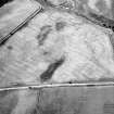
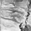
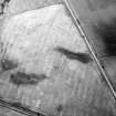
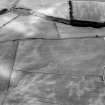
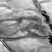
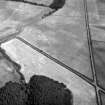
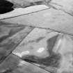
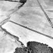
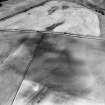
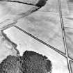
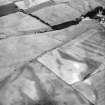
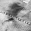
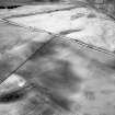
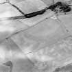
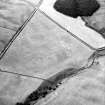
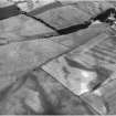
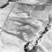
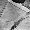
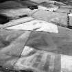
Two large Roman camps are visible on A.Ps. and on R.A.F. cover at approximately NS 8917 0314. No trace of them could be found on the ground when visited 5.9.49. (Inf. from J K St Joseph 1949)
Further crop marks were traced at NS 8909 0301 and NS 8902 0287, but not confirmed on the ground. (Inf. from A E Truckell 1953)
The sites of these camps fall in an area of uneven ground now under plough. There are no ground surface remains to be seen.
Visited by OS (BS) 20 March 1975
Publication Account (17 December 2011)
Discovered in 1949 by St Joseph from the air, the two camps at Durisdeer lie in pasture fields on a south-westfacing slope on the south-west side of the Lowther Hills, on the Roman road running from Drumlanrig in Nithsdale towards Crawford in Annandale. An Antonine fortlet lies some 2km up the Roman road to the northeast. Camp II is wholly enclosed within camp I, and the modern road on the presumed line of the Roman road runs through both.
Camp I is almost square in form, measuring 474m from south-west to north-east by 460m enclosing 21.7ha (53.7 acres). No entrances are known, but the cropmarks of the perimeter ditch are patchy because the camp has been recorded only in pasture.
Camp II measures 246m from north-west to southeast by about 210m transversely, although the north-west end is wider than that to the south-east. Some 5.1ha (12.7 acres) are enclosed, and entrance gaps protected by tituli are visible in the centre of north-west and south-east sides. A further entrance gap is visible in the centre of the southwest side.
R H Jones
Aerial Photographic Transcription (16 April 2012)

