Accessibility

Font Size

100% 150% 200%

Background Colour

Default Contrast
Close Reset

Durisdeer Parish Church

Church (17th Century), Covenanters Grave (17th Century), War Memorial(S) (20th Century)

Site Name Durisdeer Parish Church

Classification Church (17th Century), Covenanters Grave (17th Century), War Memorial(S) (20th Century)

Alternative Name(s) Durisdeer Parish School; Durisdeer, Martyr's Grave, Lower Dalveen Farm; War Memorial To Hendry Bros And Mcjannet Bros, Rolls Of Honour

Canmore ID 46336

Site Number NS80SE 12

NGR NS 89407 03770

Datum OSGB36 - NGR

Permalink http://canmore.org.uk/site/46336

Ordnance Survey licence number AC0000807262. All rights reserved.
Canmore Disclaimer. © Bluesky International Limited 2025. Public Sector Viewing Terms

Toggle Aerial | View on large map

Digital Images

Durisdeer Parish Church. General view from North East.
Durisdeer Parish Church. General view from North East.Durisdeer Parish Church. View of clock tower from South East.Durisdeer Parish Church. View of session house from South.Durisdeer Parish Church. Session House. Ground Floor. View of stone staircase from South.Durisdeer Parish Church. Session House. First floor. Kitchen. General view from South West.Durisdeer Parish Church. Clock Tower. Detail of masonry on second level.Durisdeer Parish Church. Detail of blocked entrance on South elevation.Oblique aerial view from SW of village with parish church in the centre.View from S.General view from S.Oblique aerial view of Durisdeer, centred on the parish church, taken from the N.Durisdeer Parish Church. General view from South East.Durisdeer Parish Church. General view from North East.Durisdeer Parish Church. Detail of font bracket on pulpit.Durisdeer Parish Church. South Aisle View of communion box pews converted into communion tables from South West.Durisdeer Parish Church. General view from West gallery.Durisdeer Parish Church. View of staircase leading to South gallery.Durisdeer Parish Church. General view from North East.Durisdeer Parish Church. View of entrance on South elevation.Durisdeer Parish Church. Clock Tower. Detail of bell.Durisdeer Parish Church. View of Session House from North West.Durisdeer Parish Church.  Detail of hymnbook ledge in flat position.Oblique aerial view from NE of village with the parish church in the centre.Durisdeer Parish Church, NS80SE 12, Ordnance Survey index card, page number 2, VersoView from SE, showing part of churchyardDurisdeer Parish Church. General view from North East.Durisdeer Parish Church. Detail of clock on South gallery.Durisdeer Parish Church. Detail of light fitting above pulpit.Durisdeer Parish Church. General view from West.Durisdeer Parish Church. General view from South East.Durisdeer Parish Church. General view from South.Durisdeer Parish Church. Session House. Ground floor. Room 2. View of blocked doorway from North West..Durisdeer Parish Church. Session House. First floor. Kitchen. Detail of fireplace.Durisdeer Parish Church.  View from South East.Durisdeer Parish Church, NS80SE 12, Ordnance Survey index card, page number 1, RectoDurisdeer Parish Church, NS80SE 12, Ordnance Survey index card, RectoGeneral view from SE.General view from NE.View of W wing and tower from S.Durisdeer Parish Church. Detail of hourglass bracket on pulpit.Durisdeer Parish Church. View of pulpit from South East.Durisdeer Parish Church. Session House. First floor. Hall. General view from North East.Durisdeer Parish Church. Session House. First floor. Hall. Detail of fireplace.Durisdeer Parish Church. View of mausoleum from North East.Oblique aerial view from SE of village with parish church in centre.General view from E.View from SW.Durisdeer Parish Church. South Aisle View of box pews from South West.Durisdeer Parish Church. View of box pews from North East.Durisdeer Parish Church. Detail of column supporting South gallery..Durisdeer Parish Church. General view from East.Durisdeer Parish Church. View looking into mausoleum behind pulpit from South.Durisdeer Parish Church. Detail of box pew on West gallery.Durisdeer Parish Church. Detail of coat hooks above box pew of West gallery.Durisdeer Parish Church. Detail of 18th Century chair in South gallery.Durisdeer Parish Church. General view from East.Durisdeer Parish Church. View of entrance gates from South.Durisdeer Parish Church. Session House. General view of vestry from South West.Durisdeer Parish Church. Session House. Ground Floor. Detail of worn steps on stone staircase.Durisdeer Parish Church. Session House. Ground Floor. Hall. View from South.Oblique aerial view from S of village with parish church in the centre.Durisdeer Parish Church, NS80SE 12, Ordnance Survey index card, page number 4, RectoDetail of lighting bracket.Oblique aerial view of Durisdeer, centred on the parish church, taken from the SSW.Durisdeer Parish Church. View from East.Detail of sundial on South elevation, Durisdeer Parish Church.Durisdeer Parish Church. Detail of skylight above pulpit.Durisdeer Parish Church. Detail of hymnbook ledge in sloped position.Durisdeer Parish Church. Detail of 18th Century chair in South gallery.Durisdeer Parish Church. View of entrance on East elevation.Durisdeer Parish Church. View of entrance on South elevation.Durisdeer Parish Church. Session House. General view of vestry from North East.Durisdeer Parish Church. Session House. Ground floor. Detail of South Doorway from North.Durisdeer Parish Church. Session House. Ground floor. Hall. Detail of East doorway from West.Durisdeer Parish Church. Session House. Ground floor. Room 2. General view from South West.Durisdeer Parish Church. Session House. First floor. Landing. General view from South West.Durisdeer Parish Church, NS80SE 12, Ordnance Survey index card, page number 2, VersoView from S.Detail of door.Oblique aerial view of Durisdeer, centred on the parish church, taken from the E.Oblique aerial view of Durisdeer, centred on the parish church, taken from the NE.Durisdeer Parish Church. Detail of sundial on South elevation.Durisdeer Parish Church. South Aisle View of communion box pews converted into communion tables.Durisdeer Parish Church. View of pulpit from South West..Durisdeer Parish Church. General view from NorthDurisdeer Parish Church. Detail of hymnbook ledge showing construction.Durisdeer Parish Church. View of pews on West gallery.Durisdeer Parish Church. View of minister's door from North East.Durisdeer Parish Church. View of session house from South West.Durisdeer Parish Church. View of West gallery.Durisdeer Parish Church. View of staircase leading to West gallery.Durisdeer Parish Church. View of arch and window on South elevation.Durisdeer Parish Church. Detail of window on West elevation.Distant view of Durisdeer village with church visible.Durisdeer Parish Church, NS80SE 12, Ordnance Survey index card, page number 1, RectoDurisdeer Parish Church, NS80SE 12, Ordnance Survey index card, page number 3, RectoDetail of door.Durisdeer Parish Church. View of clock tower from South East.Durisdeer Parish Church. View from South East.Durisdeer Parish Church. Detail of hymnbook ledge showing construction.

First 100 images shown. See the Collections panel (below) for a link to all digital images.

Administrative Areas

  • Council Dumfries And Galloway
  • Parish Durisdeer
  • Former Region Dumfries And Galloway
  • Former District Nithsdale
  • Former County Dumfries-shire

Archaeology Notes

NS80SE 12.00 89407 03770

NS80SE 12.01 NS 89399 03776 Monument; Mausoleum; Vault

NS80SE 12.02 NS 8942 0376 Burial-Ground

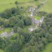
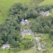
(NS 8940 0376) Church (NAT)

OS 6" map (1957)

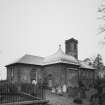
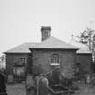
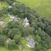
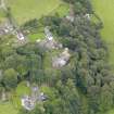
It is not known when the original Durisdeer parish church, which Ramage suggests was dedicated to St Cuthbert, was built. The present church was built in 1699, repaired in 1776 (Name Book 1857), and renovated in the mid-19th century.

A tombstone on the S side of the church marks the grave of Daniel McMichel, a Covenanter, shot at Dalveen in 1685.

A 10th century cross-fragment, found in the wall of the old church, is now in Dumfries Museum.

RCAHMS 1920, visited 1912; G Hay 1957; C T Ramage 1876; H Scott 1917; W G Collingwood 1926; A E Truckell 1966

Activities

Field Visit (4 January 1978)

Durisdeer parish church is as described and still in use. The tombstone of Daniel McMichel, known as the Martyr's Grave stands alongside the south wall of the church at NS 8939 0375. No further information could be obtained regarding either the original building or the dedication to St Cuthbert.(Rev J W Scott, Durisdeer)

The 10th century cross-fragment is still in Dumfries Museum. Martyr's Grave surveyed at 1/2500.

Visited by OS (BS) 4 January 1978.

Publication Account (1986)

Somewhat unexpected in its moorland village setting, this building is of a size and quality above that of the average Scottish rural parish kirk. It owes this superiority to the patronage of the Queensberry family of Drumlanrig (No 25), and its most distinguished feature is the family's burial-aisle on the north side of the church. Ashlar-built and ogival-roofed, this Baroque creation is marble-floored inside and conains a white marble baldaachino (canopy) placed over the entrace to the burial-vault of the 1st Duke of Queensberry, builder of Drumlanrig. This was designed by James Smith, architect, whilst the mural monument in the north wall to the 2nd 'Union' Duke and his wife was carved in 1713 by the Anglo-Dutch sculptor above the south door, is of a cruciform plan with former school building at the west end. The tall timber spire of its central tower was removed in the late 19th century.

The churchyard monuments include a table-tomb to Daniel McMichael, a Covenanter killed in 1685, and a headstone, also of 1685, which commemorates four children of William Lukup, Master of Works at Drumlanrig. The stone bears the relief-carved effigy of a mason holding a mell and a chisel.

Information from ‘Exploring Scotland’s Heritage: Dumfries and Galloway’, (1986).

Stranding (2009 - 2011)

A record of Church Furnishings was compiled by the National Association of Decorative and Fine Arts Societies (NADFAS) for Durisdeer Parish Church c2009-11.

Project (February 2014 - July 2014)

A data upgrade project to record war memorials.

Note

See also NS80SE 12 01 for Queensberry Mausoleum and Douglas Burial Vault

NS80SE 12 02 for Durisdeer Parish Church, churchyard

NMRS REFERENCE:

Architects:

James Smith - baldacchino, 1707-08

John Fair - rebuilding, 1716-17

Jan Van de Nost - Queensberry Monument, c.1710-20

External Reference

EXTERNAL REFERENCE:

Drumlarig House - model of the Queensberry Monument

Drawing in the Bodleian Library, Oxford, Gough Maps, (see 7 Physick).

References

MyCanmore Image Contributions


Contribute an Image

MyCanmore Text Contributions