
Pricing Change
New pricing for orders of material from this site will come into place shortly. Charges for supply of digital images, digitisation on demand, prints and licensing will be altered.
Badcall, Pier And Store


Jetty (19th Century), Quay (19th Century), Storehouse (19th Century)
Site Name Badcall, Pier And Store
Classification Jetty (19th Century), Quay (19th Century), Storehouse (19th Century)
Alternative Name(s) Eddrachillis, Fishing Station; Badcall, Warehouse; Badcall Bay
Canmore ID 4595
Site Number NC14SE 17
NGR NC 16419 41549
NGR Description Centred on NC 16419 41549
Datum OSGB36 - NGR
Permalink http://canmore.org.uk/site/4595


- Council Highland
- Parish Eddrachillis
- Former Region Highland
- Former District Sutherland
- Former County Sutherland
NC14SE 17 Centred on NC 16419 41549
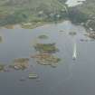
(Location cited as NC 164 415). Badcall, pier and store, c. 1800. A stretch of coursed-rubble quay and a jetty, with a 2-storey, 11-bay store, now converted to houses.
J R Hume 1976.
Slipways [NAT]
OS 1:10,000 map, 1992.

