
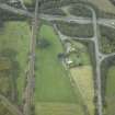
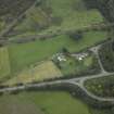
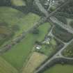
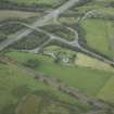
Castlecary


Roman Road (Roman)
Site Name Castlecary
Classification Roman Road (Roman)
Alternative Name(s) Castle Cary
Canmore ID 45868
Site Number NS77NE 60
NGR NS 79 78
Datum OSGB36 - NGR
Permalink http://canmore.org.uk/site/45868


- Council Falkirk
- Parish Falkirk
- Former Region Central
- Former District Falkirk
- Former County Stirlingshire
NS77NE 60 79 78
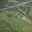
It is claimed that during the excavations at Castlecary in 1902 a road was traced for about 1000ft from the S gate of the fort, terminating at what appeared to be an old stone-quarry. At a distance of 200ft from the fort this road is said to have thrown off a branch, 15ft wide; and on an accompanying sketch-map the branch is called 'Military Way from the South', and is shown as running almost due S, for about half a mile to an unnamed tributary of the Red Burn, its further course being cut off by the margin of the map.
In the absence of any photographs or measured drawings, it is difficult to know how far this information can be relied upon. On the one hand it is likely enough that a metalled road issued from the S gate of the fort, and the excavators can hardly have invented the branch road, particularly since they state that its width was only half that of the 'quarry' road. On the other hand it is highly doubtful whether either road was traced to the extent claimed on the sketch-map. The embankment of the Glasgow and Stirling railway cuts across the line of the 'quarry' road only 500ft from the fort, and the so-called 'quarry' lies not more than 200ft beyond the embankment and is, in fact, purely a natural hollow at the foot of a strip of rising ground. Nor are any indications of the branch road visible on the surface at the present time - the stone revetment on either side of the streamlet that crosses the line being comparatively modern, and not, as the excavators believed, the remains of a Roman culvert.
It is possible that what the excavators actually found was merely the junction between a loop road, skirting round the S side of the fort, and the road that issued from the S gate. Loop roads were commonly employed on the Antonine Wall to enable through traffic to avoid passing through each of the forts; and at Castlecary such a loop road may well have been required to make a wider detour than usual owing to the morass that covered the S front of the fort.
RCAHMS 1963, visited 1956; M Buchanan 1903

