
Stonehouse, Manse Road, St Ninian's Church, Churchyard And Martyr's Tomb


Burial Ground (Medieval) - (Post Medieval), Church (Medieval), Covenanters Grave (17th Century)
Site Name Stonehouse, Manse Road, St Ninian's Church, Churchyard And Martyr's Tomb
Classification Burial Ground (Medieval) - (Post Medieval), Church (Medieval), Covenanters Grave (17th Century)
Canmore ID 45596
Site Number NS74NW 4
NGR NS 74812 47011
NGR Description Centred on NS 74812 47011
Datum OSGB36 - NGR
Permalink http://canmore.org.uk/site/45596


- Council South Lanarkshire
- Parish Stonehouse (East Kilbride)
- Former Region Strathclyde
- Former District East Kilbride
- Former County Lanarkshire
NS74NW 4.00 74812 47011
NS74NW 4.01 NS 7478 4702 cist
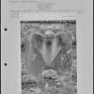
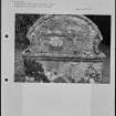
(NS 7478 4702) St. Ninian's Church (NR) (Ruin)
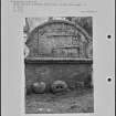
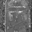
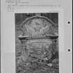
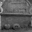
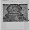
(NS 7479 4701) Martyr's Tomb (NAT)
OS 6" map (1913)
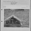
All that remains of St Ninians Church is a gable end of a pre-Reformation Church and its foundations. Parish and churchyard were dedicated in the 9th c. to St Ninian.
J A Wilson 1936-7; Stonehouse Office Guide, undated
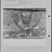
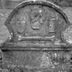
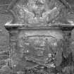
All that now remains of St Ninian's Church is the west gable-end which stands to its full height and is complete with bell-turret . The martyr's Tomb commemmorates the death of James Thomson who was shot in an encounter at Drumclog June 1st 1679.
Visited by OS (AC) 23 June 1959.
Earth Resistance Survey (17 March 2018)
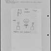
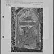
NS 74812 47011 Resistance and ground penetrating radar (GPR) surveys were carried out, 17 March 2018, to the SW of the ruins of St Ninian’s Church, Stonehouse. The aim
of the survey was to confirm the existence and location of a postulated tunnel believed to run from the graveyard associated with St Ninian’s. The area available for survey was limited due to livestock pens and other material and as a result only a 20 x 40m area was investigated. However, the postulated tunnel, if it existed, should have crossed the survey area.
Resistance survey at 0.5m intervals using a standard 0.5m probe separation, which maps to a depth of c0.75m, was undertaken. GPR survey using a 500MHz and a 250Mhz
antanea was also undertaken. A 500MHz antenna should retrieve data to a depth of c2m while a 250MHz antenna should retrieve data to c4m. Both surveys detected broad variations which are thought to be due natural variations within the underlying sands. No anomalies consistent with a tunnel type feature were detected.
The survey was part of a community event with members the Stonehouse Heritage Group (as part of CAVLP) assisting with the data collection. The survey was commissioned and
organised by Archaeology Scotland as part of the Adopt a Monument scheme.
Archive: Rose Geophysical Consultants
Funder: Archaeology Scotland on behalf of the Stonehouse
Heritage Group
Susan Ovenden – Rose Geophysical Consultants
(Source: DES, Volume 19)
Project (17 March 2018)
NS 74812 47011 Resistance and ground penetrating radar
(GPR) surveys were carried out, 17 March 2018, to the SW
of the ruins of St Ninian’s Church, Stonehouse. The aim
of the survey was to confirm the existence and location
of a postulated tunnel believed to run from the graveyard
associated with St Ninian’s.
The area available for survey was limited due to livestock
pens and other material and as a result only a 20 x 40m
area was investigated. However, the postulated tunnel, if it
existed, should have crossed the survey area.
Resistance survey at 0.5m intervals using a standard 0.5m
probe separation, which maps to a depth of c0.75m, was
undertaken. GPR survey using a 500MHz and a 250Mhz
antanea was also undertaken. A 500MHz antenna should
retrieve data to a depth of c2m while a 250MHz antenna
should retrieve data to c4m.
Both surveys detected broad variations which are thought
to be due natural variations within the underlying sands.
No anomalies consistent with a tunnel type feature were
detected.
The survey was part of a community event with members
the Stonehouse Heritage Group (as part of CAVLP) assisting
with the data collection. The survey was commissioned and
organised by Archaeology Scotland as part of the Adopt a
Monument scheme.
Archive: Rose Geophysical Consultants
Funder: Archaeology Scotland on behalf of the Stonehouse
Heritage Group
Susan Ovenden – Rose Geophysical Consultants
(Source: DES, Volume 19)
Ground Penetrating Radar (17 March 2018)
NS 74812 47011 GPR survey using a 500MHz and a 250Mhz antanea was also undertaken. A 500MHz antenna should retrieve data to a depth of c2m while a 250MHz antenna should retrieve data to c4m. Both surveys detected broad variations which are thought to be due natural variations within the underlying sands. No anomalies consistent with a tunnel type feature were
detected.
The survey was part of a community event with members the Stonehouse Heritage Group (as part of CAVLP) assisting with the data collection. The survey was commissioned and organised by Archaeology Scotland as part of the Adopt a Monument scheme.
Archive: Rose Geophysical Consultants
Funder: Archaeology Scotland on behalf of the Stonehouse
Heritage Group
Susan Ovenden – Rose Geophysical Consultants
(Source: DES, Volume 19)

