|
Photographs and Off-line Digital Images |
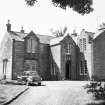
DF 4264 |
List C Survey |
View of farmhouse from SE. |
1975 |
Item Level |
|
|
Photographs and Off-line Digital Images |
DF 4265 |
List C Survey |
View of farmhouse from NW. |
1975 |
Item Level |
|
|
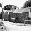
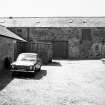
Photographs and Off-line Digital Images |
DF 4266 |
List C Survey |
View of steading from W. |
1975 |
Item Level |
|
|
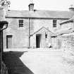
Photographs and Off-line Digital Images |
DF 4267 |
List C Survey |
View of farmhouse from S. |
1975 |
Item Level |
|
|
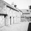
Photographs and Off-line Digital Images |
DF 4268 |
List C Survey |
View of steading from E. |
1975 |
Item Level |
|
|
Photographs and Off-line Digital Images |
DFD 238/1 |
Copies of records from the Buccleuch Estates, Scotland |
Photographic copy of drawing showing plans of farmhouse. |
1863 |
Item Level |
|
|
Photographs and Off-line Digital Images |
DFD 238/2 |
Copies of records from the Buccleuch Estates, Scotland |
Photographic copy of drawing showing plans and elevation of farmhouse. |
|
Item Level |
|
|
Photographs and Off-line Digital Images |
DFD 238/3 |
Copies of records from the Buccleuch Estates, Scotland |
Photographic copy of drawing showing plans, section and elevation of steading. |
1909 |
Item Level |
|
 |
On-line Digital Images |
SC 1632941 |
List C Survey |
View of farmhouse from SE. |
1975 |
Item Level |
|
 |
On-line Digital Images |
SC 1632942 |
List C Survey |
View of farmhouse from NW. |
1975 |
Item Level |
|
 |
On-line Digital Images |
SC 1632943 |
List C Survey |
View of steading from W. |
1975 |
Item Level |
|
 |
On-line Digital Images |
SC 1632944 |
List C Survey |
View of farmhouse from S. |
1975 |
Item Level |
|
 |
On-line Digital Images |
SC 1632945 |
List C Survey |
View of steading from E. |
1975 |
Item Level |
|
 |
On-line Digital Images |
SC 2429766 |
Records of the Ordnance Survey, Southampton, Hampshire, England |
Rigg, NS71SW 17, Ordnance Survey index card, Recto |
c. 1958 |
Item Level |
|


