
Duartbeg


Township (Period Unassigned)
Site Name Duartbeg
Classification Township (Period Unassigned)
Alternative Name(s) Dowartbeg
Canmore ID 4549
Site Number NC13NE 4
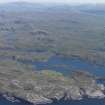
NGR NC 164 390
Datum OSGB36 - NGR
Permalink http://canmore.org.uk/site/4549


- Council Highland
- Parish Eddrachillis
- Former Region Highland
- Former District Sutherland
- Former County Sutherland
NC13NE 4 169 390
Dowartbeg (now Duartbeg).
W Roy 1747-55.
Seven ruined buildings and enclosures, measuring 6.5m x 3.0m - 13.0m x 5.0m, and 0.4m maximum height.
Visited by OS (WDJ) 21 April 1961.
Archaeological Evaluation (24 February 2021 - 26 February 2021)
Lynne McKeggie and Lachlan McKeggie – Highland Archaeology Services
NC 16360 38970, NC 16317 38915, NC 16349 38915, NC 16317
38850 A walkover survey and evaluation were undertaken on 24–26 February 2021 to identify and record visible archaeological remains in advance of a proposed development. A single oval enclosure was identified and hand-excavated in order to characterise it and retrieve potential dating evidence. The single trench spanned the southern wall and stretched into the centre of the enclosure. The wall was found to be of dry stone construction with no internal features within the enclosure. A number of finds were recovered from within the enclosure, including 35 small ceramic sherds almost exclusively white fabric and white glazed along with one piece of ironwork and two small fragments of glass. One piece of ceramic was recovered from the wall but as it was very high up in the structure was not felt to be secure. All finds are deemed insecure but point to fairly intense modern or early modern activity on the site. Although in other contexts this level of activity would not be deemed unusual, for such a rural area this points to a well-functioning Duart Beg township in the late 1700s into the early 1800s.
NC 16360 38970 post-medieval enclosure (relates to Canmore
ID: 4549).
NC 16317 38915 post-medieval structure and enclosure (relates to Canmore ID: 4549).
NC 16349 38915 wall footings, probably late 19th- century. NC 16317 38850 dry stone wall, probably late 19th- century.
Archive: NRHE and Highland HER Funder: Private individual

