
Pricing Change
New pricing for orders of material from this site will come into place shortly. Charges for supply of digital images, digitisation on demand, prints and licensing will be altered.
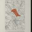
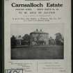
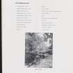
Whitehill


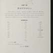
Farmhouse (Period Unassigned), Farmstead (Period Unassigned)
Site Name Whitehill
Classification Farmhouse (Period Unassigned), Farmstead (Period Unassigned)
Canmore ID 45488
Site Number NS71SE 30
NGR NS 7727 1100
NGR Description Centred on NS 7727 1100
Datum OSGB36 - NGR
Permalink http://canmore.org.uk/site/45488


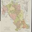


- Council Dumfries And Galloway
- Parish Kirkconnel
- Former Region Dumfries And Galloway
- Former District Nithsdale
- Former County Dumfries-shire
NS71SE 30 centred 7727 1100

