
Burga Water


Dun (Period Unassigned)
Site Name Burga Water
Classification Dun (Period Unassigned)
Canmore ID 453
Site Number HU25SW 5
NGR HU 2341 5398
Datum OSGB36 - NGR
Permalink http://canmore.org.uk/site/453


- Council Shetland Islands
- Parish Walls And Sandness
- Former Region Shetland Islands Area
- Former District Shetland
- Former County Shetland
HU25SW 5 2341 5398.
( HU 2340 5398 ) Brough (O.E.)
OS 6" map, Shetland, 2nd ed., (1903)
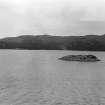
The remains of a broch, occupying the whole surface of an islet.
All that can be seen from the shore (the site was inaccessible) is part of the outer wallface, rising to a height of three or four courses above the debris on the south side. (A description by Anderson, quoting the Rev J Russel: [Anderson 1899]).
The Statistical Account (OSA) records that there was an artificial causeway leading to it from the shore, in a serpentine form 'and somewhat under water'. (OSA 1798).
No trace of this causeway, however, was detected.
An unpublished excavation was carried out some years before 1931 (Spence 1899)
RCAHMS 1946. Visited 1931
Not a broch but a dun, occupying an islet in Burga Water. The crudely-built, dry-stone wall varies from 2.5m thick at the S entrance, down to 1.0m thick in the SE, and survives to a height of 1.2m. Judging by the amount of tumble lying outside the dun, the walls cannot have been more than 3.0 m high originally. The area enclosed measures 11.0m E-W by 10.5m N-S ad both faces of the wall are visible for most of its perimeter: in the SE steep rock outcrop has been utilised as part of the defences. The walls have been built up at a later date, un- doubtedly after the pre-1931 excavation. Soundings around the island failed to locate a causeway.
Visited by OS(NKB) 20 June 1968
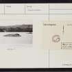
Photo & Survey Diagram.
Publication Account (2002)
HU25 4 BURGA WATER 2 (‘Holm of Burga Water’)
HU/234540
Thought to have been a possible broch in Walls and Sandness, occupying the whole surface of an islet in a loch of the same name [2], it has recently been visited and diagnosed as a relatively thin-walled dun [1] (but see HU42 1, Burraland where the wallhead is thin because it stands relatively high although mainly concealed under its own debris). The site was “torn up by Mr sand some years ago” [3].
Part of the crudely built outer wall face, rising to a height of three or four courses above debris, is exposed; it is only 2.5 - 1.0m thick [1].
There is supposed to have been a causeway to the shore [4] but this can no longer be seen [2] and soundings failed to locate it [1]. In 1774 the site was seen from the shore by George Low who described it as a 'Pight's castle' with the wall standing to about 7 ft. [5].
Sources: 1. OS card HU 25 SW 5 (with sketch plan): 2. RCAHMS 1946, vol. 3, no. 1606, 146: 3. Spence 1899, 53: 4. Statistical Acct. 1798, xx, 112-13; 5. Low 1774.
E W MacKie 2002

