|
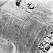
Photographs and Off-line Digital Images |
B 51640 PO |
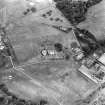
Cambridge University Collection for Aerial Photography |
Aerial photograph. |
31/7/1979 |
Item Level |
|
|
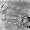
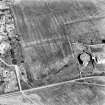
Photographs and Off-line Digital Images |
B 51641 PO |
Cambridge University Collection for Aerial Photography |
Aerial photograph. |
31/7/1979 |
Item Level |
|
|
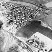
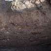
Photographs and Off-line Digital Images |
DB 1393 |
RCAHMS Aerial Photography |
Oblique aerial view. |
1979 |
Item Level |
|
|
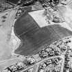
Photographs and Off-line Digital Images |
DB 1514 |
RCAHMS Aerial Photography |
Oblique aerial view. |
1981 |
Item Level |
|
|
Photographs and Off-line Digital Images |
DB 1515 |
RCAHMS Aerial Photography |
Oblique aerial view. |
1981 |
Item Level |
|
|
Photographs and Off-line Digital Images |
DB 894 |
RCAHMS Aerial Photography |
Oblique aerial view. |
1977 |
Item Level |
|
|
Photographs and Off-line Digital Images |
DB 895 |
RCAHMS Aerial Photography |
Oblique aerial view. |
1977 |
Item Level |
|
|
Photographs and Off-line Digital Images |
DB 896 |
RCAHMS Aerial Photography |
Oblique aerial view. |
1977 |
Item Level |
|
|
Manuscripts |
MS 830/5 |
Records of AOC Archaeology Group, archaeologists, Loanhead, Midlothian, Scotland |
Report of Archaeological Assessment of Kelvin Valley Sewer |
1992 |
Item Level |
|
 |
On-line Digital Images |
SC 1724958 |
RCAHMS Aerial Photography |
Oblique aerial view. |
1979 |
Item Level |
|
 |
On-line Digital Images |
SC 1724959 |
RCAHMS Aerial Photography |
Oblique aerial view. |
1981 |
Item Level |
|
 |
On-line Digital Images |
SC 1724960 |
RCAHMS Aerial Photography |
Oblique aerial view. |
1981 |
Item Level |
|
 |
On-line Digital Images |
SC 1724963 |
RCAHMS Aerial Photography |
Oblique aerial view. |
1977 |
Item Level |
|
 |
On-line Digital Images |
SC 1724964 |
RCAHMS Aerial Photography |
Oblique aerial view. |
1977 |
Item Level |
|
 |
On-line Digital Images |
SC 1724965 |
RCAHMS Aerial Photography |
Oblique aerial view. |
1977 |
Item Level |
|
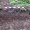 |
On-line Digital Images |
DP 305023 |
Records from Headland Archaeology Ltd, archaeologists, Edinburgh, Scotland |
Watching brief photograph, Twechar Roman Temporary Camp, Section of cable trench |
3/11/2012 |
Item Level |
|
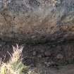 |
On-line Digital Images |
DP 305024 |
Records from Headland Archaeology Ltd, archaeologists, Edinburgh, Scotland |
Watching brief photograph, Twechar Roman Temporary Camp, Section of anchor trench |
3/11/2012 |
Item Level |
|
 |
On-line Digital Images |
DP 305025 |
Records from Headland Archaeology Ltd, archaeologists, Edinburgh, Scotland |
Watching brief photograph, Twechar Roman Temporary Camp, Section of pole removal trench |
3/11/2012 |
Item Level |
|
|
Digital Files (Non-image) |
WP 006060 |
Records from Headland Archaeology Ltd, archaeologists, Edinburgh, Scotland |
Report: Written Scheme of Investigation for Archaeological Works, Twechar Power Line Pole Replacement |
7/2014 |
Item Level |
|
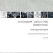 |
Digital Files (Non-image) |
WP 006066 |
Records from Headland Archaeology Ltd, archaeologists, Edinburgh, Scotland |
Report: Twechar Roman Temporary Camp, Dunbartonshire, Archaeological Watching Brief |
6/2015 |
Item Level |
|
|
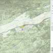
Digital Files (Non-image) |
GV 007521 |
Records of Historic Scotland, Edinburgh, Scotland |
Map 5 of 8 from IV.I 1-8 - Series 1: Maps of the Antonine Wall at a scale of 1:25000 showing the proposed World Heritage Site, known forts and fortlets, camps, other features and the buffer zones. Maps were prepared for the nomination document to propose the extension of the Frontiers of the Roman Empire World Heritage Site through the addition of the Antonine Wall. |
2006 |
Item Level |
|
 |
On-line Digital Images |
SC 1926557 |
Records of Historic Scotland, Edinburgh, Scotland |
Map 5 of 8 from IV.I 1-8 - Series 1: Maps of the Antonine Wall at a scale of 1:25000 showing the proposed World Heritage Site, known forts and fortlets, camps, other features and the buffer zones. Maps were prepared for the nomination document to propose the extension of the Frontiers of the Roman Empire World Heritage Site through the addition of the Antonine Wall. |
2006 |
Item Level |
|
|
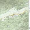
Digital Files (Non-image) |
GV 007528 |
Records of Historic Scotland, Edinburgh, Scotland |
Map 5 of 8 from IV.2 1-8 - Series 2: Maps of the Antonine Wall at a scale of 1:25000 showing the proposed World Heritage Site, known forts and fortlets, camps, other features and the buffer zones. Maps were prepared for the nomination document to propose the extension of the Frontiers of the Roman Empire World Heritage Site through the addition of the Antonine Wall. |
2006 |
Item Level |
|
 |
On-line Digital Images |
SC 1927886 |
Records of Historic Scotland, Edinburgh, Scotland |
Map 5 of 8 from IV.2 1-8 - Series 2: Maps of the Antonine Wall at a scale of 1:25000 showing the proposed World Heritage Site, known forts and fortlets, camps, other features and the buffer zones. Maps were prepared for the nomination document to propose the extension of the Frontiers of the Roman Empire World Heritage Site through the addition of the Antonine Wall. |
2006 |
Item Level |
|


