
Following the launch of trove.scot in February 2025 we are now planning the retiral of some of our webservices. Canmore will be switched off on 24th June 2025. Information about the closure can be found on the HES website: Retiral of HES web services | Historic Environment Scotland
Antonine Wall, Auchendavy - Shirva


Frontier Defence (Roman)
Site Name Antonine Wall, Auchendavy - Shirva
Classification Frontier Defence (Roman)
Alternative Name(s) Wester Shirva
Canmore ID 45157
Site Number NS67NE 21
NGR NS 6890 7548
NGR Description NS 6765 7500 to NS 7000 7588
Datum OSGB36 - NGR
Permalink http://canmore.org.uk/site/45157


- Council East Dunbartonshire
- Parish Kirkintilloch (Strathkelvin)
- Former Region Strathclyde
- Former District Strathkelvin
- Former County Dunbartonshire
NS67NE 21.00 6765 7500 to 7000 7588
NS67NE 21.01 NS 6782 7500 to NS c.6971 7573 Antonine Wall; Military Way
Formerly entered as RRX (NS 505 680 751 to NS 684 752).
NS 69 75 About a mile to the E of Kirkintilloch, a trench cut for the laying of a pipe line by Messrs Whatling Ltd., revealed the Antonine Ditch, 32ft. wide and at least 11 and a half ft. deep. No traces of the Antonine Wall or of its stone base survived.
A S Robertson 1963.
NS 684 752 The Wall and ditch were identified in a gas-pipe trench on their expected line.
L J F Keppie 1974; D R Wilson 1975.
NS 6765 7500 to NS 6781 7503 The published line (OS 25 inch 1958) was resurveyed. Only amorphous broad hollows of the Ditch survive in long grass (unsurveyable as slopes), but the remains are consistent with the repositioned alignment angle just W of NS 6781 7503 that the survey on the 2nd edition of the OS 25 inch map (Dumbartonshire 1898, sheet 33/3) indicates.
NS 6781 7503 to NS 6800 7511 The published line (OS 25 inch 1958) was resurveyed. No trace of any of the Wall features is now visible in light pasture, although the approximate course is not in doubt. Sharply defined slopes of the Ditch are shown on the 2nd edition of the OS 25 inch map (Dumbartonshire 1898, sheet 33/3) and as late as 1957 a broad shallow depression (unsurveyable) was noted by an OS field investigator.
The resurveyed course is based on re-examination of the 1898 survey in conjunction with RAF vertical aerial photographs (CPE/ SCOT/ 265A.PtII, frame no 5235-6, 1947), CUCAP aerial photographs GN67-8 and the evidence at NS 6786 7502. The heresay evidence at NS 6792 7507 is inconsistent with this re-established Ditch line, given the average dimensions for this sector - Ditch 9m wide and a berm 6m. The Wall should pass beneath Shirva Dyke Cottage.
NS 6783 7505 The depression of the Ditch is fairly plain here (Macdonald 1934).
NS 6783 7504 In 1980 a field drain trench disturbed the stone base of the Rampart about 15m N of the B 8023 road on the published line (Keppie and Breeze 1981).
NS 6792 7507 Macdonald quotes a ploughman at Shirva as to the Wall foundations being some 10ft to 12 ft N of Shirva Dyke Cottage (Macdonald 1934).
NS 6800 7511 to NS 6866 7528 The published course (OS 25 inch 1968) was resurveyed. There are no ground remains apart from the spread profile of the Ditch and Outer Mound preserved at the hedge lines at NS 6819 7517 and at NS 6840 7523. The modified line is based on the re-examination of the 2nd edition of the OS 25 inch map (Dumbartonshire 1898, sheet 33/3) survey, and the evidence at NS 6842 7523. The repositioned alignment angle W of NS 6840 7523 was deduced from the 1898 survey in conjunction with the ground topography and CUCAP aerial photographs GN67-80 (1951).
NS 6842 7523 The Wall base and edge of the Ditch were located in a pipe trench about 1973 (Keppie 1978).
NS 6866 7528 to NS 6879 7534 The published course (OS 25 inch 1968) was resurveyed. The conspicuous remains of the Ditch and Rampart are shown on 2nd edition of the OS 25 inch map (Stirlingshire 1898, sheet 28/15) are now almost obliterated. In the pasture, no intelligible remains of the Rampart survive and the Ditch now exists as a broad terrace.
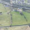
NS 6872 7529 to NS 6891 7548 Macdonald suggests the line swings N to NS 6891 7548 to avoid low marshy ground to the S, and the modern road probably overlies the Military Way here (Macdonald 1934).
NS 6879 7534 to NS 6900 7548 The published course (OS 25 inch 1968) was resurveyed. No evidence has been found to support Macdonald's (1934) conjectured 'dog-leg' course (as formerly published). It would seem that part of a natural land fold was followed, but the angle is impracticable for alignment sighting, and would not avoid the low marshy ground N of the Board Burn. Indeed, any projected course would have to cross this low ground.
Pointers to the actual course are the old hollow way at NS 6900 7548, now carrying the modern road, but which must almost certainly be the remains of the Ditch line, and the sharp bend in the Board Burn at NS 6879 7534, typical of an obstruction detour. The straight between these points forms the most direct and efficient crossing of this difficult ground.
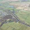
NS 6900 7548 to NS 6921 7554 The published course (OS 25 inch 1968) was resurveyed. There is no recorded evidence for extant remains here, though there are pointers to the probable course. At NS 6900 7548 the Ditch is preserved as part of a hollow-way now carrying the road (see also NS 6879 7534 to NS 6900 7548), and this is also the optimum position for a significant alignment change (i.e. sighting and change of slope). A swelling against a farm wall at NS 6903 7549 may be the rampart line, while another distinctive swelling on the hedge-line at NS 6906 7551 is consistent with the profile of the Outer Mound. At NS 6913 7551 is an amorphous linear swelling in front of the hedge line that should indicate the Rampart, while beyond this a narrow terrace indicates the line of the Ditch.
NS 6921 7554 to NS 6971 7573 Macdonald quotes a witness as to the old mineral railway, during its construction, partly overlying the Military Way and at one point touching the Rampart itself.
The Ditch appears along the stretch as an ill-defined hollow (Macdonald 1934).
The published course (OS 25 inch 1968) was resurveyed. The amorphous spread of the Ditch and Outer Mound is just discernible in pasture along most of this length. A banked hedge-line is on the course of the Rampart, and a road and housing development have long since replaced the old railway line. The former published alignment angle at NS 6921 7554 cannot be substantiated and has been adjusted. Given the probable topography prior to the cutting of the Forth and Clyde canal, no alignment change would have been required, and there is no ground evidence to support it.
NS 6971 7573 to NS 7000 7588 The published course (OS 25 inch 1968) was resurveyed. No surface traces across a developed area. The line has been slightly modified in sympathy with the known straight to E and W. The alignment angles at NS 6971 7573 and at NS 6996 7587 are at the optimum changes of slope.
Information from OS 1980
L J F Keppie 1978; L J F Keppie and D J Breeze 1982; G Macdonald 1934
NS 684 752 The stone base of the Wall was disturbed during the laying of field-drains E of Auchendavy Farm, and observed in section, on the alignment shown on OS maps.
L J F Keppie and J J Walker 1982; 1990
NS 688 755. The alignments of the wall, ditch and Military Way, E of Shirva Farm, were plotted by resistivity survey in the hope of locating an interval fortlet or other installation, without result. The wall appeared to lie S of the position given on current OS maps.
L J F Keppie 1996
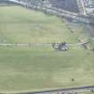
NS 6865 7525 - NS 6918 7552 The line of the Antonine Wall has been confirmed between Shirva Farm and Wester Shirva through a programme of geophysical survey and trial excavations. These works were undertaken as part of Historic Scotland's review of the Scheduling of this monument.
Sponsor: Historic Scotland
B Glendinning 1998
NS 680 752-NS 638 738 An archaeological watching brief was undertaken for selected sections of the wayleave of the Kelvin Valley sewer: Stage 2, Phase 1 between Wester Shirva and Dryfield, and passing to the N of Kirkintilloch. Features of archaeological interest included:
NS 674 750 Manholes 27 to 31. Shallow ditches and other cut features were identified at the foot of the slope to the N of the Antonine Wall just to the W of the fort at Auchendavie. At least three of the ditches appear to be of Roman date and contained a small assemblage of Antonine pottery and some slag. They form the northern end of a rectangular enclosure 80m wide. The majority of the ditches are of a later date but stratified artefacts were limited to one sherd of medieval pottery. These ditches also appear to form the northern ends of enclosures, presumably with some agricultural function.
Access to the pipeline between Manholes 27 and 31 required two temporary roads to be laid over the Antonine Wall. Under the terms of Scheduled Monument Consent the line of each road was evaluated before construction began. A 1.5m wide trench was stripped of topsoil in order to locate the precise position of the wall base and ditch. Detailed measurements were made of the topsoil and markers inserted to monitor the impact of construction traffic using the road on the underlying deposits. At Access Road 16 (NS 6817 7516) the wall base survived as a few scattered cobbles and the ditch was identified 13-14m wide; both features were in their expected locations. At Access Road 14 (NS 6741 7490), only the ditch was identified as an 18m wide band roughly 25m S of its expected position. The wall base is believed to lie beneath the B8023 road at this point.
Sponsors: Historic Scotland, West of Scotland Water.
A Hunter-Blair 1999
NS 687 752 to NS 690 755 Geophysical survey in heavily waterlogged ground designed to establish the alignment of the Wall more precisely, suggested that it lay N of the position marked on the OS sheets. The ditch was located in three separate points between the farms of Shirva and Wester Shirva. It appeared to have a width of 6m -7m. In one trench, traces of an upcast mound survived N of the Ditch. Subsequent excavation (in January 1999) in advance of possible sewerage works allowed the alignment to be further corrected. The Ditch was shown to be c.8m wide; core samples of its fill were removed for analysis.
L J F Keppie 1999.
NS 6885 7542 An archaeological investigation across the Antonine frontier, around the Board Burn, was conducted in advance of the proposed Kelvin Valley sewer pipeline. Previous work (Glendinning 1998) had identified traces of the Antonine ditch between Shirva Farm and Wester Shirva. From this, several possible alignments of the ditch were possible, the most extreme of these placing the ditch 90m N of the B8023 road and thus within the wayleave of the proposed sewer. The objective of this investigation was to identify the nature and extent of the remains of the Antonine frontier in the low-lying ground to the NE of the burn, as ground conditions during the 1998 fieldwork had prevented the confirmation of its alignment at this point.
Two trial trenches were excavated, revealing the remains of the Antonine ditch, although no trace of the outer mound or the rampart were identified. The results of the excavation confirmed that the ditch crosses the Board Burn about 2m to the N of the B8023 road. This places it further to the S than had been suggested by the previous fieldwork.
A full report has been lodged with the NMRS.
Sponsor: West of Scotland Water.
B Glendinning 1999
NS 6885 7542 The report on the excavation at Board Burn States that there investigations place the Antonine Ditch 17m further south than had been suggested be previous work. It was also established the proposed root of the Kelvin Valley Sewer should not affect the remains of the Antonine Frontier.
Sponsor: West of Scotland Water.
NMRS MS/726/150 (Edinburgh University Centre for Field Archaeology. February 1999)
The Wall descends towards the canal bridge (NS67NE 18) at Twechar. The hollow of the Ditch can be faintly discerned on the N side of housing in the village of Twechar, facing the Canal. It continues in a line towards the farmhouse of Shirva, then follows a route close to the modern B8023 road. A geophysical survey plus a limited excavation undertaken in 1998 and 1999 have together served to confirm the exact alignment.
Anne S. Robertson/Lawrence Keppie 2001.
NS 6747 7504 In May 1999 Headland Archaeology Ltd carried out an archaeological watching brief during the construction of the Kelvin Valley Sewer. A possible Roman enclosure was discovered NW of the Antonine Wall at Auchendavy. This section of the sewer ran along the foot of the slope below Auchendavy Farm, 100m N of the Antonine Wall and adjacent to the River Kelvin. Access to this section of the sewer required the creation of two temporary roads over the line of the Antonine Wall and the opportunity was taken to confirm its precise position at these points (At NS 6742 7492 (see NS67SE 42.00) and at NS 6817 7516) Monitoring during the stripping of the way-leave for the pipe trench identified archaeological features over a 150m section. The majority of features uncovered appeared to form part of a medieval or later field enclosure system. Three stratigraphically earlier ditches contained only Roman artefacts and their close proximity to the Antonine Wall and Roman fort (see NS67SE 12) at Auchendavy suggested that they might be contemporary with the frontier wall.
A machine-excavated trench was opened along the length of the proposed route for both access roads along the Antonine Wall; both were stripped of topsoil and hand-cleaned in order to confirm the position of the Rampart and Ditch so that they could be protected during construction of the access roads. Both the Rampart base and Ditch were revealed in Access Road 16 (At NS 6817 9516) just N of the B8023 road, confirming the assumed location of the Antonine Wall. Preservation of the Rampart base was extremely poor with only a small number of stones remaining. Only the Ditch (see NS67SE 42.00 at NS 6742 7491) was uncovered at Access Road 14 (at NS 6742 7516). It was recorded further S than expected and this indicates that the Wall curves to the SW.
M Hastie 2002
A Dunwell, G Bailey, A Leslie, A Smith 2002.
NS 688 754 Three separate evaluations took place between 1998 and 2001 along the Antonine Wall between Wester Shirva and Shirva Farm, including the crossing point of the Board Burn.
First, in October 1998 geophysical survey and trial trenching were conducted between Wester Shirva and Shirva (NS 6865 7525-NS 6981 7552). These results had not confirmed the crossing point of the Board Burn by the frontier works, and several different alignments were possible. The geophysics depicted an anomaly representing a large ditched feature. Trenches were placed to examine these anomalies, which proved to be the Ditch. The second trial trenching evaluation was undertaken in January 1999 to confirm the line of the Ditch just to the E of the Board Burn (at NS 6885 7542). The Ditch had a surface width varying between 6m and 8m. The Ditch edges were steep sided although they became noticeably shallower towards the surface. A core was taken through the centre of the Ditch in order to characterize the nature of the deposits and to determine their palaeoenvironmental potential. The core sample was not subject to detailed palaeoenvironmental analysis. Putative remains of the Outer Mound were identified along the northern lip of the Ditch in one of the trenches. No further archaeological features of any kind were located.
Finally, during 2000 and 2001, a watching brief was undertaken on sewer construction works. As part of this exercise, a third evaluation was undertaken a Shirva. The objectives of this work were to determine the location of the Ditch and assess the degree of compression of the underlying sediments. Excavation here revealed a feature, which has been interpreted as a natural palaeochannel masked by subsequent inorganic flood deposits.
Overall, the results from this work have allowed the alignment of the frontier works to be better understood in this area. To the W of the Board Burn, the Ditch alignment was confirmed substantially on its previously extrapolated alignment. To the E of the burn, however, it appears that the frontier alignment lies to the S of its previously mapped position, either within the grounds of Shirva Farm or beneath the road. It is notable that the Ditch forms a straight alignment to either side of Board Burn, unlike the kinking route which had been proposed formerly. The presence of peat fills within the Ditch is of importance because of the potential of such deposits for the undertaking landscape and land-use reconstruction through pollen analysis.
Extrapolation of the opposed Ditch alignments confirmed to the SW and NE of the Board Burn indicates that the Ditch should have crossed the SE end of Trench 10, but it is absent. One possibility is that the Ditch had never been constructed across the alignment of the burn. However it has been argued that a lack of a Ditch may be too great of a potential weakness across the frontier line. A second possibility is the Ditch alignment is kinked southwards slightly for a short distance on both sides of the burn, to create a re-entrant angle providing additional protection to any gap the frontier works at the burn crossing.
No consistent trace of the Outer Mound was located. There was no evidence for defensive pits on the Berm, although most trenches did not extend S of the Ditch. No remains of the Rampart were identified at this location. No evidence for the proposed fortlet was recovered, though work did not cover the areas best suited to the siting of one. No evidence relating to the souterrain (see NS67NE 13) was recovered.
A Dunwell, G Bailey, A Leslie, A Smith 2002.
[NS 67829 75031 to NS 69164 75534]. Length scheduled as 'Antonine Wall, 855m WSW to 605m ENE of Wester Shirva...' (Scheduling number 727).
Information from Historic Scotland, scheduling document dated 26 November 2009.
Field Visit (1934)
NS 6783 7505 The depression of the Ditch is fairly plain here (Macdonald 1934).
Publication Account (1934)
NS 6921 7554 to NS 6971 7573 Macdonald quotes a witness as to the old mineral railway, during its construction, partly overlying the Military Way and at one point touching the Rampart itself.
Field Visit (1934)
NS 6921 7554 to NS 6971 7573 The Ditch appears along the stretch as an ill-defined hollow (Macdonald 1934).
Field Visit (1934)
NS 6872 7529 to NS 6891 7548 Macdonald suggests the line swings N to NS 6891 7548 to avoid low marshy ground to the S, and the modern road probably overlies the Military Way here (Macdonald 1934).
Publication Account (1934)
NS 6792 7507 Macdonald quotes a ploughman at Shirva as to the Wall foundations being some 10ft to 12 ft N of Shirva Dyke Cottage (Macdonald 1934).
Aerial Photography (29 July 1945)
Salvage Record (1963)
NS 69 75 About a mile to the E of Kirkintilloch, a trench cut for the laying of a pipe line by Messrs Whatling Ltd., revealed the Antonine Ditch, 32ft. wide and at least 11 and a half ft. deep. No traces of the Antonine Wall or of its stone base survived.
A S Robertson 1963.
Salvage Record (1973)
NS 684 752 The Wall and ditch were identified in a gas-pipe trench on their expected line.
L J F Keppie 1974; D R Wilson 1975.
NS 6842 7523 The Wall base and edge of the Ditch were located in a pipe trench about 1973 (Keppie 1978).
Salvage Record (June 1980)
NS 6783 7504 In 1980 a field drain trench disturbed the stone base of the Rampart about 15m N of the B 8023 road on the published line (Keppie and Breeze 1981).
Field Visit (1980)
NS 6781 7503 to NS 6800 7511 The published line (OS 25 inch 1958) was resurveyed. No trace of any of the Wall features is now visible in light pasture, although the approximate course is not in doubt. Sharply defined slopes of the Ditch are shown on the 2nd edition of the OS 25 inch map (Dumbartonshire 1898, sheet 33/3) and as late as 1957 a broad shallow depression (unsurveyable) was noted by an OS field investigator.
The resurveyed course is based on re-examination of the 1898 survey in conjunction with RAF vertical aerial photographs (CPE/ SCOT/ 265A.PtII, frame no 5235-6, 1947), CUCAP aerial photographs GN67-8 and the evidence at NS 6786 7502. The heresay evidence at NS 6792 7507 is inconsistent with this re-established Ditch line, given the average dimensions for this sector - Ditch 9m wide and a berm 6m. The Wall should pass beneath Shirva Dyke Cottage.
Information from OS 1980
Field Visit (1980)
NS 6800 7511 to NS 6866 7528 The published course (OS 25 inch 1968) was resurveyed. There are no ground remains apart from the spread profile of the Ditch and Outer Mound preserved at the hedge lines at NS 6819 7517 and at NS 6840 7523. The modified line is based on the re-examination of the 2nd edition of the OS 25 inch map (Dumbartonshire 1898, sheet 33/3) survey, and the evidence at NS 6842 7523. The repositioned alignment angle W of NS 6840 7523 was deduced from the 1898 survey in conjunction with the ground topography and CUCAP aerial photographs GN67-80 (1951).
Information from OS 1980
Field Visit (1980)
NS 6765 7500 to NS 6781 7503 The published line (OS 25 inch 1958) was resurveyed. Only amorphous broad hollows of the Ditch survive in long grass (unsurveyable as slopes), but the remains are consistent with the repositioned alignment angle just W of NS 6781 7503 that the survey on the 2nd edition of the OS 25 inch map (Dumbartonshire 1898, sheet 33/3) indicates.
Information from OS 1980
Field Visit (1980)
NS 6866 7528 to NS 6879 7534 The published course (OS 25 inch 1968) was resurveyed. The conspicuous remains of the Ditch and Rampart are shown on 2nd edition of the OS 25 inch map (Stirlingshire 1898, sheet 28/15) are now almost obliterated. In the pasture, no intelligible remains of the Rampart survive and the Ditch now exists as a broad terrace.
Information from OS 1980
Field Visit (1980)
NS 6971 7573 to NS 7000 7588 The published course (OS 25 inch 1968) was resurveyed. No surface traces across a developed area. The line has been slightly modified in sympathy with the known straight to E and W. The alignment angles at NS 6971 7573 and at NS 6996 7587 are at the optimum changes of slope.
Information from OS 1980
Field Visit (1980)
NS 6900 7548 to NS 6921 7554 The published course (OS 25 inch 1968) was resurveyed. There is no recorded evidence for extant remains here, though there are pointers to the probable course. At NS 6900 7548 the Ditch is preserved as part of a hollow-way now carrying the road (see also NS 6879 7534 to NS 6900 7548), and this is also the optimum position for a significant alignment change (i.e. sighting and change of slope). A swelling against a farm wall at NS 6903 7549 may be the rampart line, while another distinctive swelling on the hedge-line at NS 6906 7551 is consistent with the profile of the Outer Mound. At NS 6913 7551 is an amorphous linear swelling in front of the hedge line that should indicate the Rampart, while beyond this a narrow terrace indicates the line of the Ditch.
Information from OS 1980
Field Visit (1980)
NS 6879 7534 to NS 6900 7548 The published course (OS 25 inch 1968) was resurveyed. No evidence has been found to support Macdonald's (1934) conjectured 'dog-leg' course (as formerly published). It would seem that part of a natural land fold was followed, but the angle is impracticable for alignment sighting, and would not avoid the low marshy ground N of the Board Burn. Indeed, any projected course would have to cross this low ground. Pointers to the actual course are the old hollow way at NS 6900 7548, now carrying the modern road, but which must almost certainly be the remains of the Ditch line, and the sharp bend in the Board Burn at NS 6879 7534, typical of an obstruction detour. The straight between these points forms the most direct and efficient crossing of this difficult ground.
Information from OS 1980
Salvage Record (1982)
NS 684 752 The stone base of the Wall was disturbed during the laying of field-drains E of Auchendavy Farm, and observed in section, on the alignment shown on OS maps.
L J F Keppie and J J Walker 1982; 1990
Earth Resistance Survey (1995)
NS67NE 21.00 From 6765 7500 to 7000 7588
NS 688 755 A geophysical survey at Shirva Farm was initially conducted immediately to the N of the B8023 road. this was to confirm the route of the Antonine Rampart and to test whether evidence of possible extensions of the wall-base, projecting to the S, could be detected. Results did not confirm the Rampart route but its alignment in the fields to the E and W seems to indicate that its most likely track is mainly through the main field and that it crosses the B8023 at the Board Burn.
A Strang and J Walker 1995.
NS 688 755. The alignments of the wall, ditch and Military Way, E of Shirva Farm, were plotted by resistivity survey in the hope of locating an interval fortlet or other installation, without result. The wall appeared to lie S of the position given on current OS maps.
L J F Keppie 1996
Trial Trench (21 January 1998)
Kelvin Valley sewer stage 2: Dryfield to Auchendavie Farm ground investigation archaeological watching brief for Wimtec Environmental Ltd on behalf of West of Scotland Water.
Carter, S
Trial Trench (October 1998 - October 1998)
NS 6865 7525 - NS 6918 7552 The line of the Antonine Wall has been confirmed between Shirva Farm and Wester Shirva through a programme of geophysical survey and trial excavations. These works were undertaken as part of Historic Scotland's review of the Scheduling of this monument.
Sponsor: Historic Scotland
B Glendinning 1998
NS 688 754 Three separate evaluations took place between 1998 and 2001 along the Antonine Wall between Wester Shirva and Shirva Farm, including the crossing point of the Board Burn.
First, in October 1998 geophysical survey and trial trenching were conducted between Wester Shirva and Shirva (NS 6865 7525-NS 6981 7552). These results had not confirmed the crossing point of the Board Burn by the frontier works, and several different alignments were possible. The geophysics depicted an anomaly representing a large ditched feature. Trenches were placed to examine these anomalies, which proved to be the Ditch.
B Glendinning 1998
A Dunwell, G Bailey, A Leslie, A Smith 2002.
Earth Resistance Survey (October 1998 - October 1998)
NS 6865 7525 - NS 6918 7552 The line of the Antonine Wall has been confirmed between Shirva Farm and Wester Shirva through a programme of geophysical survey and trial excavations. These works were undertaken as part of Historic Scotland's review of the Scheduling of this monument.
Sponsor: Historic Scotland
B Glendinning 1998
NS 687 752 to NS 690 755 Geophysical survey in heavily waterlogged ground designed to establish the alignment of the Wall more precisely, suggested that it lay N of the position marked on the OS sheets. The ditch was located in three separate points between the farms of Shirva and Wester Shirva. It appeared to have a width of 6m -7m. In one trench, traces of an upcast mound survived N of the Ditch. Subsequent excavation (in January 1999) in advance of possible sewerage works allowed the alignment to be further corrected. The Ditch was shown to be c.8m wide; core samples of its fill were removed for analysis.
L J F Keppie 1999.
NS 688 754 Three separate evaluations took place between 1998 and 2001 along the Antonine Wall between Wester Shirva and Shirva Farm, including the crossing point of the Board Burn.
First, in October 1998 geophysical survey and trial trenching were conducted between Wester Shirva and Shirva (NS 6865 7525-NS 6981 7552). These results had not confirmed the crossing point of the Board Burn by the frontier works, and several different alignments were possible. The geophysics depicted an anomaly representing a large ditched feature. Trenches were placed to examine these anomalies, which proved to be the Ditch. The second trial trenching evaluation was undertaken in January 1999 to confirm the line of the Ditch just to the E of the Board Burn (at NS 6885 7542). The Ditch had a surface width varying between 6m and 8m. The Ditch edges were steep sided although they became noticeably shallower towards the surface. A core was taken through the centre of the Ditch in order to characterize the nature of the deposits and to determine their palaeoenvironmental potential. The core sample was not subject to detailed palaeoenvironmental analysis. Putative remains of the Outer Mound were identified along the northern lip of the Ditch in one of the trenches. No further archaeological features of any kind were located.
Finally, during 2000 and 2001, a watching brief was undertaken on sewer construction works. As part of this exercise, a third evaluation was undertaken a Shirva. The objectives of this work were to determine the location of the Ditch and assess the degree of compression of the underlying sediments. Excavation here revealed a feature, which has been interpreted as a natural palaeochannel masked by subsequent inorganic flood deposits.
Overall, the results from this work have allowed the alignment of the frontier works to be better understood in this area. To the W of the Board Burn, the Ditch alignment was confirmed substantially on its previously extrapolated alignment. To the E of the burn, however, it appears that the frontier alignment lies to the S of its previously mapped position, either within the grounds of Shirva Farm or beneath the road. It is notable that the Ditch forms a straight alignment to either side of Board Burn, unlike the kinking route which had been proposed formerly. The presence of peat fills within the Ditch is of importance because of the potential of such deposits for the undertaking landscape and land-use reconstruction through pollen analysis.
Extrapolation of the opposed Ditch alignments confirmed to the SW and NE of the Board Burn indicates that the Ditch should have crossed the SE end of Trench 10, but it is absent. One possibility is that the Ditch had never been constructed across the alignment of the burn. However it has been argued that a lack of a Ditch may be too great of a potential weakness across the frontier line. A second possibility is the Ditch alignment is kinked southwards slightly for a short distance on both sides of the burn, to create a re-entrant angle providing additional protection to any gap the frontier works at the burn crossing.
No consistent trace of the Outer Mound was located. There was no evidence for defensive pits on the Berm, although most trenches did not extend S of the Ditch. No remains of the Rampart were identified at this location. No evidence for the proposed fortlet was recovered, though work did not cover the areas best suited to the siting of one. No evidence relating to the souterrain (see NS67NE 13) was recovered.
A Dunwell, G Bailey, A Leslie, A Smith 2002.
Trial Trench (1 January 1999 - 31 January 1999)
NS 6885 7542 An archaeological investigation across the Antonine frontier, around the Board Burn, was conducted in advance of the proposed Kelvin Valley sewer pipeline. Previous work (Glendinning 1998) had identified traces of the Antonine ditch between Shirva Farm and Wester Shirva. From this, several possible alignments of the ditch were possible, the most extreme of these placing the ditch 90m N of the B8023 road and thus within the wayleave of the proposed sewer. The objective of this investigation was to identify the nature and extent of the remains of the Antonine frontier in the low-lying ground to the NE of the burn, as ground conditions during the 1998 fieldwork had prevented the confirmation of its alignment at this point.
Two trial trenches were excavated, revealing the remains of the Antonine ditch, although no trace of the outer mound or the rampart were identified. The results of the excavation confirmed that the ditch crosses the Board Burn about 2m to the N of the B8023 road. This places it further to the S than had been suggested by the previous fieldwork.
A full report has been lodged with the NMRS.
Sponsor: West of Scotland Water.
B Glendinning 1999
NS 6885 7542 The report on the excavation at Board Burn States that their investigations place the Antonine Ditch 17m further south than had been suggested be previous work. It was also established the proposed root of the Kelvin Valley Sewer should not affect the remains of the Antonine Frontier.
Sponsor: West of Scotland Water.
NMRS MS/726/150 (Edinburgh University Centre for Field Archaeology. February 1999)
NS 688 754 Three separate evaluations took place between 1998 and 2001 along the Antonine Wall between Wester Shirva and Shirva Farm, including the crossing point of the Board Burn.
The second trial trenching evaluation was undertaken in January 1999 to confirm the line of the Ditch just to the E of the Board Burn (at NS 6885 7542). The Ditch had a surface width varying between 6m and 8m. The Ditch edges were steep sided although they became noticeably shallower towards the surface. A core was taken through the centre of the Ditch in order to characterize the nature of the deposits and to determine their palaeoenvironmental potential. The core sample was not subject to detailed palaeoenvironmental analysis. Putative remains of the Outer Mound were identified along the northern lip of the Ditch in one of the trenches. No further archaeological features of any kind were located.
B Glendinning 1999
Excavation (26 May 1999)
NS 680 752 - NS 638 738 This report details the results of an archaeological evaluation undertaken in advance of temporary road access road construction for Stage 2, Phase 1 of the Kelvin Valley Sewer. Two of these access roads, 14 and 16, cross the Scheduled Monument designated for the line of the Antonine wall. As well as surveying the surviving archaeology, soil profiles were collected and a sediment study started. The main archaeological features discovered were the ditch and poorly preserved wall base of the Antonine Wall found beneath Access Road 16, and the Antonine ditch found beneath Access road 14. The wall and ditch are poorly preserved, evidence of intensive ploughing and cultivation were found and also evidence of stone robbing.
NMRS, MS/899/120.
Watching Brief (May 1999)
NS 6747 7504 In May 1999 Headland Archaeology Ltd carried out an archaeological watching brief during the construction of the Kelvin Valley Sewer. A possible Roman enclosure was discovered NW of the Antonine Wall at Auchendavy. This section of the sewer ran along the foot of the slope below Auchendavy Farm, 100m N of the Antonine Wall and adjacent to the River Kelvin. Access to this section of the sewer required the creation of two temporary roads over the line of the Antonine Wall and the opportunity was taken to confirm its precise position at these points (At NS 6742 7492 (see NS67SE 42.00) and at NS 6817 7516) Monitoring during the stripping of the way-leave for the pipe trench identified archaeological features over a 150m section. The majority of features uncovered appeared to form part of a medieval or later field enclosure system. Three stratigraphically earlier ditches contained only Roman artefacts and their close proximity to the Antonine Wall and Roman fort (see NS67SE 12) at Auchendavy suggested that they might be contemporary with the frontier wall.
A machine-excavated trench was opened along the length of the proposed route for both access roads along the Antonine Wall; both were stripped of topsoil and hand-cleaned in order to confirm the position of the Rampart and Ditch so that they could be protected during construction of the access roads. Both the Rampart base and Ditch were revealed in Access Road 16 (At NS 6817 9516) just N of the B8023 road, confirming the assumed location of the Antonine Wall. Preservation of the Rampart base was extremely poor with only a small number of stones remaining. Only the Ditch (see NS67SE 42.00 at NS 6742 7491) was uncovered at Access Road 14 (at NS 6742 7516). It was recorded further S than expected and this indicates that the Wall curves to the SW.
M Hastie 2002
A Dunwell, G Bailey, A Leslie, A Smith 2002.
Watching Brief (May 1999)
NS 680 752-NS 638 738 An archaeological watching brief was undertaken for selected sections of the wayleave of the Kelvin Valley sewer: Stage 2, Phase 1 between Wester Shirva and Dryfield, and passing to the N of Kirkintilloch. Features of archaeological interest included:
NS 674 750 Manholes 27 to 31. Shallow ditches and other cut features were identified at the foot of the slope to the N of the Antonine Wall just to the W of the fort at Auchendavie. At least three of the ditches appear to be of Roman date and contained a small assemblage of Antonine pottery and some slag. They form the northern end of a rectangular enclosure 80m wide. The majority of the ditches are of a later date but stratified artefacts were limited to one sherd of medieval pottery. These ditches also appear to form the northern ends of enclosures, presumably with some agricultural function.
Access to the pipeline between Manholes 27 and 31 required two temporary roads to be laid over the Antonine Wall. Under the terms of Scheduled Monument Consent the line of each road was evaluated before construction began. A 1.5m wide trench was stripped of topsoil in order to locate the precise position of the wall base and ditch. Detailed measurements were made of the topsoil and markers inserted to monitor the impact of construction traffic using the road on the underlying deposits. At Access Road 16 (NS 6817 7516) the wall base survived as a few scattered cobbles and the ditch was identified 13-14m wide; both features were in their expected locations. At Access Road 14 (NS 6741 7490), only the ditch was identified as an 18m wide band roughly 25m S of its expected position. The wall base is believed to lie beneath the B8023 road at this point.
Sponsors: Historic Scotland, West of Scotland Water.
A Hunter-Blair 1999
Publication Account (2000 - 2001)
During 2000 and 2001, a watching brief was undertaken on sewer construction works. As part of this exercise, a third evaluation was undertaken at Shirva.
A Dunwell, G Bailey, A Leslie, A Smith 2002.
Watching Brief (2000 - 2001)
Watching brief as part of the Kelvin Valley Sewer project.
Aspinall, A. Sproat, D.
Watching Brief (2000 - 2001)
Watching brief caried out as continuation of work CFA did in 1998 and 1999.
Ellis, C. and Gooder, J.
Publication Account (2001)
The Wall descends towards the canal bridge (NS67NE 18) at Twechar. The hollow of the Ditch can be faintly discerned on the N side of housing in the village of Twechar, facing the Canal. It continues in a line towards the farmhouse of Shirva, then follows a route close to the modern B8023 road. A geophysical survey plus a limited excavation undertaken in 1998 and 1999 have together served to confirm the exact alignment.
Anne S. Robertson/Lawrence Keppie 2001.
Publication Account (2002)
The objectives of this work were to determine the location of the Ditch and assess the degree of compression of the underlying sediments. Excavation here revealed a feature, which has been interpreted as a natural palaeochannel masked by subsequent inorganic flood deposits.
Overall, the results from this work have allowed the alignment of the frontier works to be better understood in this area. To the W of the Board Burn, the Ditch alignment was confirmed substantially on its previously extrapolated alignment. To the E of the burn, however, it appears that the frontier alignment lies to the S of its previously mapped position, either within the grounds of Shirva Farm or beneath the road. It is notable that the Ditch forms a straight alignment to either side of Board Burn, unlike the kinking route which had been proposed formerly. The presence of peat fills within the Ditch is of importance because of the potential of such deposits for the undertaking landscape and land-use reconstruction through pollen analysis.
Extrapolation of the opposed Ditch alignments confirmed to the SW and NE of the Board Burn indicates that the Ditch should have crossed the SE end of Trench 10, but it is absent. One possibility is that the Ditch had never been constructed across the alignment of the burn. However it has been argued that a lack of a Ditch may be too great of a potential weakness across the frontier line. A second possibility is the Ditch alignment is kinked southwards slightly for a short distance on both sides of the burn, to create a re-entrant angle providing additional protection to any gap the frontier works at the burn crossing.
No consistent trace of the Outer Mound was located. There was no evidence for defensive pits on the Berm, although most trenches did not extend S of the Ditch. No remains of the Rampart were identified at this location. No evidence for the proposed fortlet was recovered, though work did not cover the areas best suited to the siting of one. No evidence relating to the souterrain (see NS67NE 13) was recovered.
A Dunwell, G Bailey, A Leslie, A Smith 2002.
Magnetometry (2 July 2007 - 5 July 2007)
The line of the Antonine Wall has been confirmed and found to correlate most closely with investigations carried out by the Centre for Field Archaeology (CFA). Of the main elements only the Ditch has been conclusively detected and appears most clearly in the magnetic data. Limited, more tentative evidence for the Rampart has been identified, again primarily in the magnetic data, in the field adjacent to Wester Shirva Farm. No clear evidence for the Military Way was found in this field. Further eastwards the Rampart is likely to run under the modern road, while the Military Way and any possible associated features lie in a field that was largely unsuitable for survey. Resistance survey in the field next to Wester Shirva farm produced anomalies that might indicate part of a rectilinear enclosure. Surface obstructions precluded the expansion of the survey area, thus the true nature and significance of these anomalies cannot be fully assessed.
OASIS ID: gsbprosp1-43961
Earth Resistance Survey (2 July 2007 - 5 July 2007)
The line of the Antonine Wall has been confirmed and found to correlate most closely with investigations carried out by the Centre for Field Archaeology (CFA). Of the main elements only the Ditch has been conclusively detected and appears most clearly in the magnetic data. Limited, more tentative evidence for the Rampart has been identified, again primarily in the magnetic data, in the field adjacent to Wester Shirva Farm. No clear evidence for the Military Way was found in this field. Further eastwards the Rampart is likely to run under the modern road, while the Military Way and any possible associated features lie in a field that was largely unsuitable for survey. Resistance survey in the field next to Wester Shirva farm produced anomalies that might indicate part of a rectilinear enclosure. Surface obstructions precluded the expansion of the survey area, thus the true nature and significance of these anomalies cannot be fully assessed.
OASIS ID: gsbprosp1-43961

