
Unst, Uyeasound


Broch (Iron Age)
Site Name Unst, Uyeasound
Classification Broch (Iron Age)
Canmore ID 45
Site Number HP50SE 25
NGR HP 5930 0104
Datum OSGB36 - NGR
Permalink http://canmore.org.uk/site/45


- Council Shetland Islands
- Parish Unst
- Former Region Shetland Islands Area
- Former District Shetland
- Former County Shetland
HP50SE 25 5930 0104.
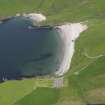
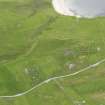
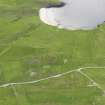
(HP 5929 0107) Brough (NR) (Site of).
OS 6" map, Shetland, 2nd ed., (1900)
A heap of stones and boulders almost entirely covered by high tide.
Name Book 1878
All that remains are two large broch-like stones protruding from the base of the pier which now overlays the broch. Part of the pier has collapsed, obscuring any trace of the rest.
Visited by OS (NKB) 5 May 1969.
Publication Account (2002)
HP50 8 MUSSELBURGH ('Uyeasound')
HP/593011.
Site of possible broch on the shore of Uyea Sound on Unst, consisting of a "heap of stones and boulders almost entirely covered by high tide"; the site is partly covered by a modern pier [1].
Sources: OS card HP50 SE 25: 2. RCAHMS 1946, vol. 3, no. 1582.

