
Scheduled Maintenance
Please be advised that this website will undergo scheduled maintenance on the following dates: •
Tuesday 3rd December 11:00-15:00
During these times, some services may be temporarily unavailable. We apologise for any inconvenience this may cause.
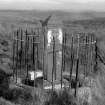
Allan's Cairn


Commemorative Cairn (19th Century), Covenanters Grave (17th Century)
Site Name Allan's Cairn
Classification Commemorative Cairn (19th Century), Covenanters Grave (17th Century)
Alternative Name(s) Covenanters' Monument
Canmore ID 44674
Site Number NS60SE 5
NGR NS 69814 00840
Datum OSGB36 - NGR
Permalink http://canmore.org.uk/site/44674


- Council Dumfries And Galloway
- Parish Dalry (Stewartry)
- Former Region Dumfries And Galloway
- Former District Stewartry
- Former County Kirkcudbrightshire
NS60SE 5 69814 00840.
(NS 6981 0083) Memorial Stone (NAT)
OS 6" map (1958)
Cairn (NR) (Remains of)
OS 6" map (1856)
A small cairn, nearly defaced, said to have been the spot where John Allan was slain during the persecution times. (The name "Allan's Cairn" is applied to the hill, on the summit of which the cairn is situated.)
Name Book 1856
Allan's Cairn : A square stone, 5 ft high (using the old cairn as a foundation) was erected in 1857, marking the spot where George Allan and Margaret Gracie are buried. They were shot by dragoons as they fled from a conventicle at the Whig's Hole (NS60SE 1). The stone bears a long inscription (fully quoted by Wilson) giving details.
J H Thomson 1891; W Wilson 1957
The memorial stone stands at the junction of three rides in an area now forestry planted. No trace of a cairn was found at this point or anywhere on the summit called Allan's Cairn.
Visited by OS (JRL) 10 November 1978

