 |
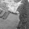
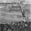
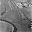
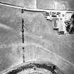
On-line Digital Images |
SC 1724900 |
RCAHMS Aerial Photography |
Oblique aerial view centred on the cropmarks of the Roman fortlet and the Antonine Wall, taken from the SW. |
28/7/2003 |
Item Level |
|
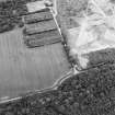 |
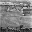
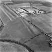
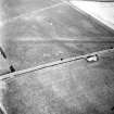
On-line Digital Images |
SC 1724901 |
RCAHMS Aerial Photography |
Oblique aerial view centred on the cropmarks of the Roman fortlet and the Antonine Wall, taken from the S. |
28/7/2003 |
Item Level |
|
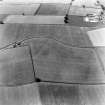 |
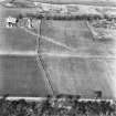
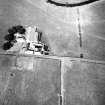
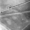
On-line Digital Images |
SC 1724905 |
RCAHMS Aerial Photography |
Oblique aerial view. |
1976 |
Item Level |
|
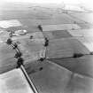 |
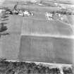
On-line Digital Images |
SC 1724906 |
|
|
1976 |
Item Level |
|
 |
On-line Digital Images |
SC 1724918 |
RCAHMS Aerial Photography |
Oblique aerial view. |
1982 |
Item Level |
|
 |
On-line Digital Images |
SC 1724919 |
RCAHMS Aerial Photography |
Oblique aerial view. |
26/1/1982 |
Item Level |
|
 |
On-line Digital Images |
SC 1724920 |
RCAHMS Aerial Photography |
Oblique aerial view. |
1982 |
Item Level |
|
 |
On-line Digital Images |
SC 1724921 |
RCAHMS Aerial Photography |
Oblique aerial view. |
28/1/1982 |
Item Level |
|
 |
On-line Digital Images |
SC 1724922 |
RCAHMS Aerial Photography |
Oblique aerial view. |
29/1/1982 |
Item Level |
|
 |
On-line Digital Images |
SC 1724923 |
RCAHMS Aerial Photography |
Oblique aerial view. |
1982 |
Item Level |
|
 |
On-line Digital Images |
SC 1724928 |
RCAHMS Aerial Photography |
Oblique aerial view |
1983 |
Item Level |
|
 |
On-line Digital Images |
SC 1724929 |
RCAHMS Aerial Photography |
Oblique aerial view. |
1983 |
Item Level |
|
 |
On-line Digital Images |
SC 1724930 |
RCAHMS Aerial Photography |
Oblique aerial view |
1983 |
Item Level |
|
 |
On-line Digital Images |
SC 1724934 |
RCAHMS Aerial Photography |
Oblique aerial view. |
1983 |
Item Level |
|
 |
On-line Digital Images |
SC 1724935 |
RCAHMS Aerial Photography |
Oblique aerial view. |
1983 |
Item Level |
|
 |
On-line Digital Images |
SC 1970706 |
Records of Historic Scotland, Edinburgh, Scotland |
Antonine Wall 1:25000 broadsheet map |
2008 |
Item Level |
|
 |
On-line Digital Images |
SC 2170806 |
Records of Historic Scotland, Edinburgh, Scotland |
Map showing the Antonine Wall, the World Heritage Site area, the areas of the World Heritage Site in public ownership or care, the Buffer Zone and the Council boundaries. Created for the World Heritage Site nomination - Management plan. |
2006 |
Item Level |
|
 |
On-line Digital Images |
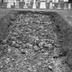
SC 2475027 |
|
RCAHMS |
1985 |
Item Level |
|
 |
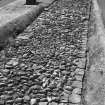
On-line Digital Images |
SC 2475028 |
|
RCAHMS |
1985 |
Item Level |
|
 |
On-line Digital Images |
SC 2475049 |
|
RCAHMS |
1985 |
Item Level |
|
 |
On-line Digital Images |
SC 2716292 |
Records of the Ordnance Survey, Southampton, Hampshire, England |
Easter Balmuildy, NS57SE RRX 505, Ordnance Survey index card, Recto |
c. 1958 |
Item Level |
|
 |
On-line Digital Images |
SC 2716293 |
Records of the Ordnance Survey, Southampton, Hampshire, England |
New Kilpatrick Cemetery, NS57SE RRX 505, Ordnance Survey index card, Recto |
c. 1958 |
Item Level |
|
 |
On-line Digital Images |
SC 2716294 |
Records of the Ordnance Survey, Southampton, Hampshire, England |
Summerston, NS57SE RRX 505, Ordnance Survey index card, Recto |
c. 1958 |
Item Level |
|
 |
On-line Digital Images |
SC 2716295 |
Records of the Ordnance Survey, Southampton, Hampshire, England |
Wilderness Plantation, NS57SE RRX 505, Ordnance Survey index card, Recto |
c. 1958 |
Item Level |
|


