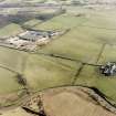
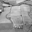
 |
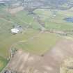
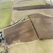
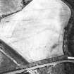
On-line Digital Images |
DP 249653 |
Historic Environment Scotland |
Oblique aerial view. |
24/3/2017 |
Item Level |
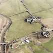
|
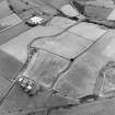
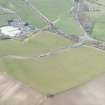 |
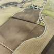
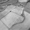
On-line Digital Images |
DP 249654 |
Historic Environment Scotland |
Oblique aerial view. |
24/3/2017 |
Item Level |
|
 |
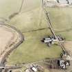
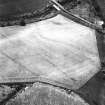
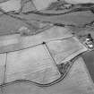
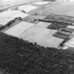
On-line Digital Images |
SC 1724855 |
RCAHMS Aerial Photography |
Aerial view of the Antonine Wall (c. 594 720) and the locations of a Roman fortlet and two Roman enclosures, taken from the NE. |
4/3/1997 |
Item Level |
|
 |
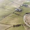
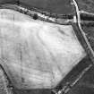
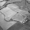
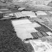
On-line Digital Images |
SC 1724856 |
RCAHMS Aerial Photography |
General aerial view of the Antonine Wall (c. 594 720) and the locations of a Roman fortlet and two Roman enclosures, taken from the ENE. |
4/3/1997 |
Item Level |
|
 |
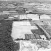
On-line Digital Images |
SC 1724857 |
RCAHMS Aerial Photography |
Aerial view of Balmuildy fort and the Antonine Wall (c.584 718), taken from the NW. |
4/3/1997 |
Item Level |
|
 |
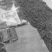
On-line Digital Images |
SC 1724858 |
RCAHMS Aerial Photography |
Aerial view of Balmuildy fort and the Antonine Wall (c.584 718), taken from the W. |
4/3/1997 |
Item Level |
|
 |
On-line Digital Images |
SC 1724859 |
RCAHMS Aerial Photography |
Aerial view of Balmuildy fort and the Antonine Wall (c.584 718), taken from the SW. |
4/3/1997 |
Item Level |
|
 |
On-line Digital Images |
SC 1724860 |
RCAHMS Aerial Photography |
Aerial view of Balmuildy fort and the Antonine Wall (c.584 718), taken from the NE. |
4/3/1997 |
Item Level |
|
 |
On-line Digital Images |
SC 1724861 |
RCAHMS Aerial Photography |
Aerial view of the Antonine Wall (c. 5774 7243), taken from the SE. |
4/3/1997 |
Item Level |
|
 |
On-line Digital Images |
SC 1724862 |
RCAHMS Aerial Photography |
Aerial view of the Antonine Wall (c. 5774 7243), taken from the NW. |
4/3/1997 |
Item Level |
|
 |
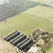
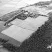
On-line Digital Images |
SC 1724863 |
RCAHMS Aerial Photography |
Oblique aerial view. |
1983 |
Item Level |
|
 |
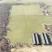
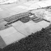
On-line Digital Images |
SC 1724864 |
RCAHMS Aerial Photography |
Oblique aerial view. |
1983 |
Item Level |
|
 |
On-line Digital Images |
SC 1724865 |
RCAHMS Aerial Photography |
Oblique aerial view. |
1983 |
Item Level |
|
 |
On-line Digital Images |
SC 1724889 |
RCAHMS Aerial Photography |
Oblique aerial view centred on the cropmarks of the Antonine Wall near Summerston Farm, taken from the NW. |
28/7/2003 |
Item Level |
|
 |
On-line Digital Images |
SC 1724890 |
RCAHMS Aerial Photography |
Oblique aerial view centred on the cropmarks of the Antonine Wall near Summerston Farm, taken from the WNW. |
28/7/2003 |
Item Level |
|
 |
On-line Digital Images |
SC 1724891 |
RCAHMS Aerial Photography |
Oblique aerial view centred on the cropmarks of the Antonine Wall near Summerston Farm, taken from the SW. |
28/7/2003 |
Item Level |
|
 |
On-line Digital Images |
SC 1724892 |
RCAHMS Aerial Photography |
Oblique aerial view centred on the cropmarks of the Antonine Wall near Summerston Farm, taken from the S. |
28/7/2003 |
Item Level |
|
 |
On-line Digital Images |
SC 1724893 |
RCAHMS Aerial Photography |
Oblique aerial view centred on the cropmarks of the Antonine Wall near Summerston Farm, taken from the SE. |
28/7/2003 |
Item Level |
|
 |
On-line Digital Images |
SC 1724894 |
RCAHMS Aerial Photography |
Oblique aerial view centred on the cropmarks of the Antonine Wall and the Roman fortlet, taken from the SW. |
28/7/2003 |
Item Level |
|
 |
On-line Digital Images |
SC 1724895 |
RCAHMS Aerial Photography |
Oblique aerial view centred on the cropmarks of the Antonine Wall and the Roman fortlet, taken from the SSW. |
28/7/2003 |
Item Level |
|
 |
On-line Digital Images |
SC 1724896 |
RCAHMS Aerial Photography |
Oblique aerial view centred on the cropmarks of the Antonine Wall and the Roman fortlet, taken from the SSE. |
28/7/2003 |
Item Level |
|
 |
On-line Digital Images |
SC 1724897 |
RCAHMS Aerial Photography |
Oblique aerial view centred on the cropmarks of the Antonine Wall and the Roman fortlet, taken from the E. |
28/7/2003 |
Item Level |
|
 |
On-line Digital Images |
SC 1724898 |
RCAHMS Aerial Photography |
Oblique aerial view centred on the cropmarks of the Antonine Wall and the Roman fortlet, taken from the ENE. |
28/7/2003 |
Item Level |
|
 |
On-line Digital Images |
SC 1724899 |
RCAHMS Aerial Photography |
Oblique aerial view centred on the cropmarks of the Roman fortlet and the Antonine Wall, taken from the W. |
28/7/2003 |
Item Level |
|


