
Newton Mearns, Waterfoot Road, Mearns Castle


Castle (Medieval)(Possible), Church (20th Century), Tower House (15th Century)
Site Name Newton Mearns, Waterfoot Road, Mearns Castle
Classification Castle (Medieval)(Possible), Church (20th Century), Tower House (15th Century)
Alternative Name(s) Maxwell Mearns Castle Church
Canmore ID 43855
Site Number NS55NE 6
NGR NS 55228 55342
Datum OSGB36 - NGR
Permalink http://canmore.org.uk/site/43855


- Council East Renfrewshire
- Parish Mearns
- Former Region Strathclyde
- Former District Eastwood
- Former County Renfrewshire
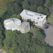
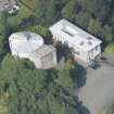
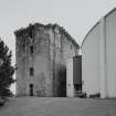
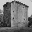
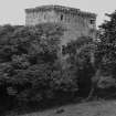
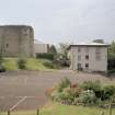
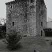
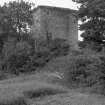
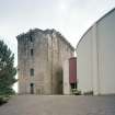
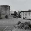
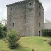
Mearns Castle, Waterfoot Road, mid-15th century
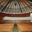
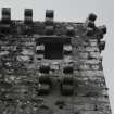
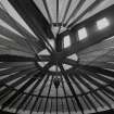
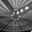
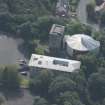
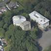
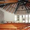
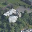
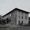
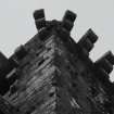
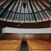
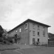
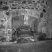
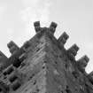
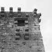
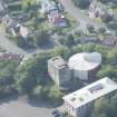
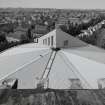
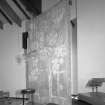
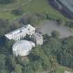
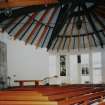
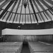
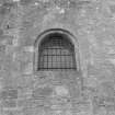
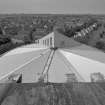
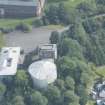
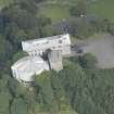
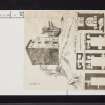
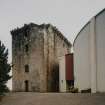
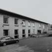
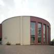
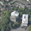
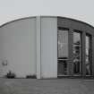
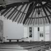
12m- (40ft-) high tower, with embattled parapet on corbelled wallhead. Much restored and combined with new circular building to become Maxwell Mearns Parish Church, c.1970, Walter Ramsay.
Taken from "Greater Glasgow: An Illustrated Architectural Guide", by Sam Small, 2008. Published by the Rutland Press http://www.rias.org.uk

NS55NE 6 55228 55342
(NS 5522 5536) Mearns Castle (NR)
OS 1:10,000 map, (1974).
See also NS55NE 21.
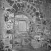
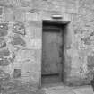
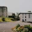
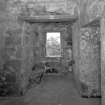
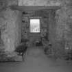
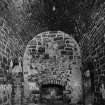
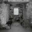
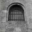
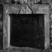
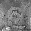
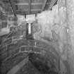
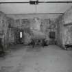
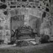
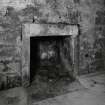
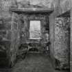
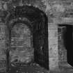
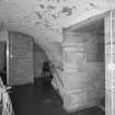
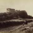
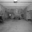
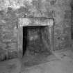
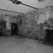
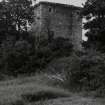
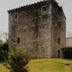
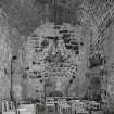
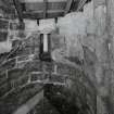
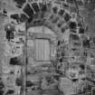
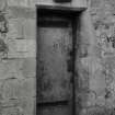
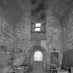
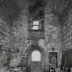
Mearns Castle occupies a very strong position, on a knoll over looking a steep valley. Much restored, it now stands about 40ft high, entire to the wallhead. It was reroofed not long before 1842, but this roof cannot be seen from the outside. A royal warrant for its erection was received by Herbert, Lord Maxwell, in 1449. The oblong keep 30ft by 40ft is four storeys high; the walls are 10ft thick. The lowermost courses are of rough, large rubble; above this is well cut ashlar, the reverse of the usual situation. Tranter therefore considers that the 15th century keep was erected on the foundations of an earlier building. The main entrance was at first floor level, reached by a ladder. Formerly, this keep was enhanced by curtain walls, outbuildings, gatehouse and drawbridge for a moat, but only faint traces of these remain.
New Statistical Account (NSA) 1845; D MacGibbon and T Ross 1887-92; S Cruden 1960; HBD No. 1; N Tranter 1962-70.
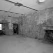
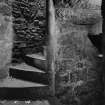
The exterior walls of this tower are in good condition, standing to their full height on all sides, they are of rubble masonry from ground level to a height of approximately 3m and of squared masonry from there to roof height. The entrance has been walled up, it is not possible to inspect the interior. The surrounding ground slopes sharply away on all sides except the south east, providing natural defences. The naturally sloping ground on the south east has been cut away to form a bank, approximately 3m high, with the remains of a causewayed entrance to the tower. The fragmentary remains of a curtain wall or barmkin are traceable, following the edge of the small rocky knoll on which the tower is situated. It encloses an area 36m north west- south east by 29m transversely. For the most part the rubble core only is visible, though a number of facing stones remain north east of the tower.
Surveyed at 1:2500.
Visited by OS (W D J) 12 May 1959.
The tower house is in the process of being converted into a church hall and a new church is to be built where the enclosure once stood. A limited excavation located a building butting against the north enclosure wall. In places the irregular rock outcrop had been levelled by cobbling. Pottery finds were 15/16th century in date. (See also NS55NE 12 and NS55NE 21 ).
E Talbot 1970.
This site was visited in the course of fieldwork by Dr. T.C. Welsh.
For further details see MS/1508 (Welsh 1983)
NS 554 553 Prior to the extension and redevelopment of existing buildings at the high school, two evaluation trenches totalling 82m2 were opened in June 2004 in the bus park area to the W of the school buildings and due S of Mearns Castle (NS55NE 6). No significant archaeological deposits or artefacts were encountered.
Archive to be deposited in the NMRS.
Sponsor: HBG Construction.
L Dunbar 2004.
The remains of the barmkin or curtain wall identified by the Ordnance Survey in 1959 have probably been removed by the construction of the new church.
Visited by RCAHMS (SH, IP), 18 June 2007.
NMRS REFERENCE
NMRS Newton Mearns Castle by Eric J. Talbot - text
NMRS Dr Thomas Ross - manuscript notes
Mid XV century tower house. 30' x 44' about 40' high. Embattled parapet on corbelled wallhead. Concrete roof.
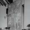
This 15th century tower house was built by Lord Maxwell and sits prominently on a steep site, overlooking a valley. It was converted for church use in the late 1960s. A new church was then built next to the tower in the early 1970s and the tower is now not used (2013). The 1970s church attached to the Tower House was not considered to be of special architectural or historic interest when assessed in 2013. (Historic Scotland)
The Maxwells were powerful knights in the service of the Scottish crown and held the important border castle of Caerlaverock. The final Maxwell to own the castle was Sir George of Nether Pollok in the 17th century. During the Covenanting period in the 1600s the castle housed a garrison of dragoons who terrorised the area. Mearns Castle was incorporated into the Maxwell Mearns Church in 1971. (East Renfrewshire Council).
Photographic Record (1885)
Photographs in album titled 'Views in Busby, East-Kilbride, Carmunnock, Mearns, Eaglesham, and their vicinity 1885'

