
Cumnock, Bank Viaduct


Railway Viaduct (19th Century)
Site Name Cumnock, Bank Viaduct
Classification Railway Viaduct (19th Century)
Alternative Name(s) Lugar Viaduct; Templand Railway Viaduct; Lugar Water; Woodroad Park
Canmore ID 43582
Site Number NS52SE 15
NGR NS 57386 20632
Datum OSGB36 - NGR
Permalink http://canmore.org.uk/site/43582


- Council East Ayrshire
- Parish Old Cumnock
- Former Region Strathclyde
- Former District Cumnock And Doon Valley
- Former County Ayrshire
NS52SE 15 57395 20624
Location also formerly cited as NS 5732 2068 to NS 5749 2054.
Not to be confused with Rosebank, Lugar Viaduct (NS 59917 21445), for which see NS52SE 12.
Viaduct [NAT] (at NS 5742 2061)
OS (GIS) AIB, June 2006.
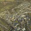
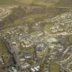
(Location cited as NS 574 205). Bank Viaduct, opened 1850 by the Glasgow, Paisley, Kilmarnock and Ayr Rly. A very fine tall 13-span masonry viaduct, with semicircular arches.
J R Hume 1976.
This viaduct carries the Kilmarnock-Dumfries portion of the Glasgow-Carlisle ('Nith Valley') main line of the former Glasgow and South Western Rly over the Lugar Water between Cumnock (NS52SE 28) and Lugar (NS52SE 30), to the SW and NE respectively. It remains in regular use by passenger traffic.
The river here forms the boundary between the parishes of Auchinleck (to the NW) and Old Cumnock (to the SE).
The location assigned to this record defines the midpoint of the river-crossing. The available map evidence indicates that the viaduct extends from NS C. 57323 20682 to NS c. 57483 20550. It is depicted, but not noted, on the 1986 edition of the OS 1:10,000 map.
Information from RCAHMS (RJCM), 1 June 2006.
Publication Account (1995)
Close by Cumnock are two impressive railway viaducts: Bank Viaduct and Glaisnock Viaduct. The railway to Cumnock was opened in 1850 by the Glasgow, Paisley, Kilmarnock and Ayr Railway Company, after the construction of this bridge over the Lugar Water. Twenty-two years later the Glasgow and South Western Railway Company built a second railway line through Cumnock, called the Ayr and Cumnock branch line, and opened the Glaisnock Viaduct figure 21. From the Middle Ages, Cumnock had been strategically placed on crossing routes, whether for foot passengers or, later, coach traffic; this function was maintained by the opening of these lines, viaducts and Cumnock's two railway stations.
Information from ‘Historic Cumnock: The Archaeological Implications of Development’ (1995).

