
Pricing Change
New pricing for orders of material from this site will come into place shortly. Charges for supply of digital images, digitisation on demand, prints and licensing will be altered.
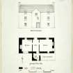
Dalnair Farm


Farmhouse (17th Century), Farmstead (19th Century), House (17th Century)
Site Name Dalnair Farm
Classification Farmhouse (17th Century), Farmstead (19th Century), House (17th Century)
Canmore ID 43421
Site Number NS48NE 25
NGR NS 49512 86062
Datum OSGB36 - NGR
Permalink http://canmore.org.uk/site/43421


- Council Stirling
- Parish Drymen
- Former Region Central
- Former District Stirling
- Former County Stirlingshire
NS48NE 25 49512 86062
Dated 1682.
(Undated) information in NMRS.
Photographic Survey (4 November 1957)
Photographic survey of Dalnair Farm, Stirlingshire, by the Scottish National Buildings Record/Ministry of Works in November 1957.

