
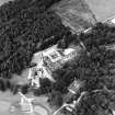
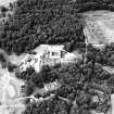
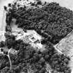
Buchanan Castle, Stables


Stable (19th Century)
Site Name Buchanan Castle, Stables
Classification Stable (19th Century)
Alternative Name(s) Buchanan Estate; Buchanan Castle Policies
Canmore ID 43412
Site Number NS48NE 21.02
NGR NS 45731 88899
Datum OSGB36 - NGR
Permalink http://canmore.org.uk/site/43412


- Council Stirling
- Parish Buchanan
- Former Region Central
- Former District Stirling
- Former County Stirlingshire
NS48NE 21.03 47229 87798
Photographic Survey (1954)
Photographic survey by the Scottish National Buildings Record in 1954.

