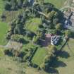
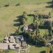
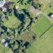
Accessibility

Font Size

100% 150% 200%

Background Colour

Default Contrast
Close Reset

Kilmaronock Castle

Tower House (15th Century) - (16th Century)

Site Name Kilmaronock Castle

Classification Tower House (15th Century) - (16th Century)

Alternative Name(s) Mains Castle

Canmore ID 43404

Site Number NS48NE 1

NGR NS 45500 87716

Datum OSGB36 - NGR

Permalink http://canmore.org.uk/site/43404

Ordnance Survey licence number AC0000807262. All rights reserved.
Canmore Disclaimer. © Bluesky International Limited 2025. Public Sector Viewing Terms

Toggle Aerial | View on large map

Digital Images

View of ruins from NW
View of ruins from NWW side. Detail of entrance to basement vaulted chamberView of ruins from ENEOblique aerial view of Kilmaronock Castle and Kilmaronock House, looking NNE.Kilmaronock Castle, NS48NE 1, Ordnance Survey index card, RectoNW corner. Detail of masonry baseW side. Detail of entrance to basement vaulted chamberView of ruins from NNWOblique aerial view of Kilmaronock Castle and Kilmaronock House, looking SE.View of ruins from NWView of ruins from NNWView of ruins from NView of ruins from SEE side. Detail of former doorwayInterior. View of S sideInterior. Detail of fireplaceGround floor plan, First floor plan and Second floor plan, Section and Site planInterior. Detail of S windowInterior. Detail of fireplaceInterior. Detail of fireplaceOblique aerial view of Kilmaronock Castle and Kilmaronock House, looking S.Oblique aerial view of Kilmaronock Castle and Kilmaronock House, looking SW.Kilmaronock Castle, NS48NE 1, Ordnance Survey index card, page number 1, RectoN side. Detail of masonryView of ruins from ENEView of ruins from ENEView of ruins from SENE corner. Detail of roll mouldingOblique aerial view of Kilmaronock Castle and Kilmaronock House, looking W.View of ruins from ENW corner. Detail of masonry baseInterior. View of E endInterior. Detail of SE cornerInterior. View of W endInterior. View of S sideInterior. Detail of fireplaceInterior. View of basement vault from WOblique aerial view of Kilmaronock Castle and Kilmaronock House, looking N.Oblique aerial view of Kilmaronock Castle and Kilmaronock House, looking NW.Oblique aerial view of Kilmaronock Castle and Kilmaronock House, looking SSW.Oblique aerial view of Kilmaronock Castle and Kilmaronock House, looking NW.View of ruins from NNWView of ruins from EView of ruins from SEE side. Detail of window and carved shieldInterior. Detail of S windowInterior. Detail of fireplaceView of ruins from EInterior. Detail of S (upper level) windowOblique aerial view of Kilmaronock Castle and Kilmaronock House, looking ENE.View of ruins from NNE corner. Detail of raggle near wallheadInterior. Detail of S (upper level) windowInterior. View of basement vault from WNE corner. Detail of raggle near wallheadN side. Detail of masonryView of ruins from SEE side. Detail of window and carved shieldOblique aerial view of Kilmaronock Castle and Kilmaronock House, looking ENE.Oblique aerial view of Kilmaronock Castle and Kilmaronock House, looking NE.View of ruins from SEInterior. View of E endInterior. Detail of S windowInterior. View of W endInterior. Detail of fireplaceView of ruins from NView of ruins from SEE side. Detail of former doorwayNE corner. Detail of roll mouldingInterior. Detail of E windowInterior. View of SW cornerOblique aerial view of Kilmaronock Castle and Kilmaronock House, looking NE.Oblique aerial view of Kilmaronock Castle and Kilmaronock House, looking NNE.Oblique aerial view of Kilmaronock Castle and Kilmaronock House, looking S.Kilmaronock Castle, NS48NE 1, Ordnance Survey index card, RectoInterior. Detail of E windowInterior. Detail of SE cornerInterior. View of SW corner

Administrative Areas

  • Council West Dunbartonshire
  • Parish Kilmaronock (Dumbarton)
  • Former Region Strathclyde
  • Former District Dumbarton
  • Former County Dunbartonshire

Archaeology Notes

NS48NE 1 45500 87716

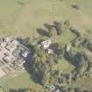
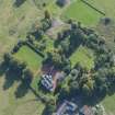
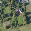
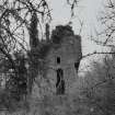
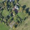
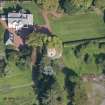
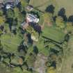
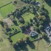
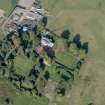
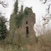
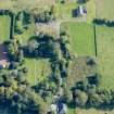
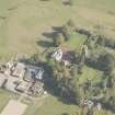
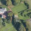
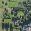
(NS 4550 8770) Kilmaronock Castle (NR) (In Ruins)

OS 6" map, Dunbartonshire, 2nd ed., (1922)

The lands of Kilmaronock are mentioned in the 14th and 15th centuries.

J Irving 1879.

The castle belonged to the Earl of Glencairn in 1695.

W Camden 1789.

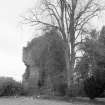
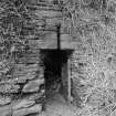
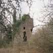
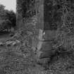
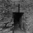
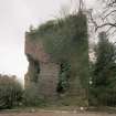
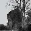
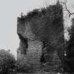
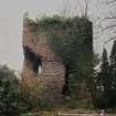
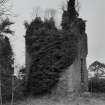
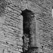
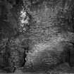
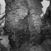
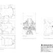
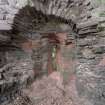
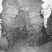
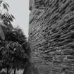
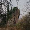
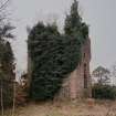
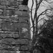
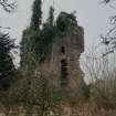
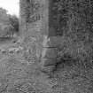
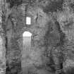
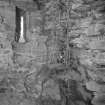
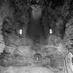
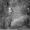
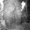
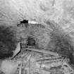
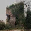
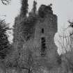
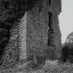
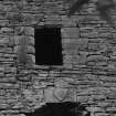
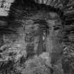
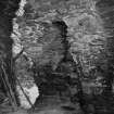
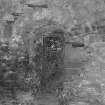
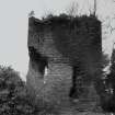
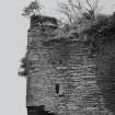
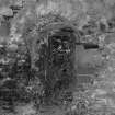
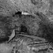
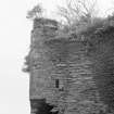
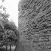
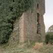
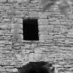
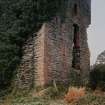
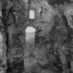
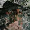
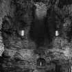
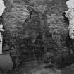
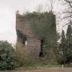
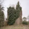
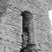
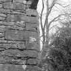
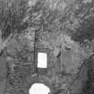
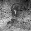
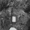
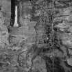
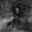
Kilmaronock Castle is an oblong tower, measuring 10.0 x 12.0m and four or five storeys high. The building is now a ruin but is in a fair state of preservation, and from the construction and design, probably dates from the late 15th - early 16th century.

Visited by OS (R D L) 21 January 1963.

Activities

Field Visit (December 1977)

Kilmaronock Castle NS 455 877 NS48NE 1

A tower of 15th- to 16th-century date.

RCAHMS 1978, visited December 1977

(MacGibbon and Ross 1887-92, v, 325-9)

References

MyCanmore Image Contributions


Contribute an Image

MyCanmore Text Contributions